Early March Winter Storm to Drop Light Snow Over New Jersey
A Winter Weather Advisory has been issued for the southern half of New Jersey from Thursday night to Friday, with a couple of inches of snow possible.
Cold air has returned to the Garden State as of Thursday morning, with low temperatures bottoming out in the lower to mid 20s. Thursday will be chilly and dry during the daytime hours, with highs limited to the mid to upper 30s statewide. While skies will begin sunny, clouds will steadily increase after about 11 a.m.
The chill sets the table for an incoming storm system to produce some snow from Thursday night through much of Friday. The center of this storm system will pass well south of New Jersey, over Virginia/North Carolina, before sliding out over the Atlantic Ocean. Over the past few days, model forecasts have subtly trended snowier, and so we have bumped up our snow forecast a little bit. Don't panic, though - this is still going to be a minor, nuisance snowstorm for New Jersey.
When will the snow begin?
The latest model output suggests the outer bands of snow will arrive in South Jersey around 10 p.m. Thursday night. The snow will spread northward through the overnight hours, likely peaking in intensity through the early morning hours of Friday.
What is a Winter Weather Advisory?
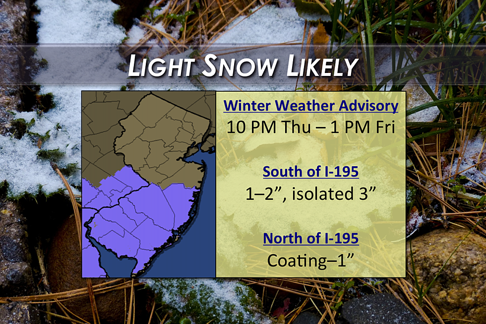
The National Weather Service has issued a Winter Weather Advisory from 10 p.m. Thursday to 1 p.m. Friday, for counties south of Interstate 195: Atlantic, Burlington, Camden, Cape May, Cumberland, Gloucester, Ocean, and Salem.
An advisory is not as severe as a warning, and merely serves to caution about potentially poor travel conditions. Part of the reasoning behind this advisory is the timing of this system, impacting the Friday morning commute. Untreated roads and elevated surfaces (such as bridges and overpasses) will be especially prone to icing and particularly slippery.
Will the ground be cold enough for snow to stick?
Good question! Soil temperatures taken 5 centimeters (1.97 inches) below the surface have been hovering in the 30s at night and near 50 degrees during the day. So the ground isn't frozen. But if it stays cold and snows hard enough? We'll see accumulations - especially on colder surfaces such as cars, trees, and grass.
Will it stay cold enough for all snow?
Another good question! Overnight lows will be in the 20s statewide, easily cold enough for an all snow scenario (rather than rain, freezing rain, etc.) After sunrise on Friday, however, this forecast gets trickier as temperatures will eventually climb above the freezing mark. In fact, high temperatures in South Jersey on Friday are expected to top 40 degrees. That is certainly warm enough to enact a transition to rain at the tail end of the system. The best chance for wintry mix and/or rain would be along the coast just as the storm pushes out to sea, around late morning Friday.
How much snow will fall?
The issue from this storm will not be bands of heavy snow forcing sharply lowered visibility and big piles of snow. Several hours of persistent light snow will cause the accumulations and the travel issues.
Our going forecast of "an inch or two" still looks solid, especially in the southern half of the state (the advisory area noted above). I could see isolated reports of 3 inches possible in South Jersey as well.
North of Interstate 195, the snow is expected to be lighter overall, and last for a shorter period of time. We'll probably see about an inch near Monmouth, Mercer, and Middlesex counties, tapering off to as little as a coating in far North Jersey.
Confidence for this snow forecast is moderate to high. My forecast is admittedly slightly lower than the National Weather Service's latest map, which shows a large swath of 2 to 3 inches extending from the Raritan River to the Delaware Bay. However, I still believe the combination of the warm ground, blowing snow, and the mixing potential will ultimately limit snow totals for New Jersey. I have seen other snow forecasts as high as 5 inches, but there is no data to support this more significant forecast. We are only on the fringe of this storm system, after all.
School and business closings and delays will likely be a game-time decision from this storm. As long as roads are pre-treated properly, I suspect most schools will be able to remain open on Friday.
When will the snow end?
As I mentioned above, some mixing with or transition to rain is possible by late morning on Friday. As the winter storm kicks further and further out to sea, precipitation will end by early afternoon across the Garden State. Skies will clear quickly, although a brisk wind and chilly temperatures will remain. Forecast highs for Friday are in the upper 30s to lower 40s.
What comes next?
This taste of cold air will be short-lived, as a slow warmup begins this weekend. Our warming trend will kick into high gear next week.
Saturday will be quiet, with a mix of sun and clouds and high temperatures in the lower 40s. A weak wave is expected to move through the skies of Jersey from Saturday night through Sunday morning. The result will be a brief period of rain or snow showers.
As winds become southwesterly Sunday through midweek, temperatures will start to soar. Mid 40s on Sunday afternoon, mid 50s on Monday, near 60 on Tuesday, and mid 60s (at least) on Wednesday! We may very well make a run for 70 degrees somewhere in New Jersey on Wednesday and Thursday - that would be our warmest weather since Christmas Eve.
Our next storm system of any significance looks to arrive in the Thursday night to Friday time frame.
More From WPG Talk Radio 95.5 FM


