
Nor’easter Still On Track To Bring Big Snow, Rain, Wind to NJ
Monday daytime will be fine. But conditions across the Garden State will rapidly deteriorate Monday night.
The Bottom Line
Forecast models have (finally) come to a solid consensus solution for our impending winter storm. It's now a lock — New Jersey is going to see a lot of snow over the next 24 to 36 hours.
The snow won't start until about 8 p.m. Monday evening. So if you have work or school on Monday, errands to run, preparations to complete, and/or shopping to do, you'll be fine during the daytime hours.
Current Conditions
One of the greatest tri-state area weather personalities of all time (and one of my mentors), Storm Field, once gave me some sage advice: The only tool a good meteorologist really needs to forecast the weather? A window.
With our big winter storm inching closer and closer to New Jersey, I think it's important and relevant to throw aside the fancy computer models for a moment and gaze out the window at our current weather picture. We can learn a lot about future weather conditions.
First, it's cold. A good sign that winter is in the air, of course. But this abnormally cold air is an important part of our winter storm setup. Most of New Jersey (away from the coast) will see all snow from this system.
Second, the ground is cold. The "antecedent soil condition" is very important for summertime storms, to gauge flash flooding potential. In this case, the frozen (and, in some places, snow-covered) ground means snow will begin to accumulate immediately.
Third, Sunday featured a full moon. The moon directly influences the Earth's ocean tides. So, the astronomical tide along the Jersey Shore is already a bit higher than usual, exacerbating the coastal flooding potential as storm surge arrives.
Finally, on my drive to work this morning, the deer were running crazy! I saw more on the roadside (and crossing the road) than I have ever before. I don't think the deer read my weather blog or listen to my on-air forecast. Yet, they clearly know something's up!
The Forecast
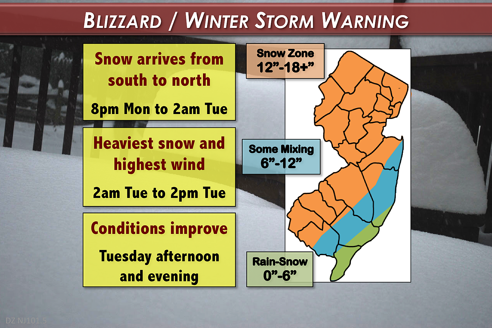
--Timing: First flakes are expected to arrive in southwestern New Jersey around 8 p.m. Monday. The peak of the storm, featuring the heaviest snowfall and highest winds, will happen from about 2 a.m. to 2 p.m. Tuesday. Conditions will generally improve from Tuesday afternoon through evening, although periods of light snow may continue through part of Wednesday.
--Snow: The snowfall "sweet spot" will include a large swath of northern and central New Jersey, in addition to the western half of South Jersey. That's where over a foot of accumulation is likely. Some models are still suggesting upwards of 24 inches, but I'm still not comfortable putting that number on my forecast map — so I continue to settle on "18+". Meanwhile, closer to the Jersey Shore, mixing with sleet and rain may mitigate overall snowfall. This will lead to lower totals, especially for coastal Atlantic and Cape May counties.
--Wind: Sustained winds of 20 to 30 mph are expected throughout the peak of the storm. Gusts over 40 mph inland and over 50 mph along the coast could cause downed trees. Scattered power outages are likely. Widespread power outages are possible.
--Surge: Those strong northeast winds will push a lot of ocean water toward the Jersey Shore. 2 to 3 feet of surge will combine with the elevated astronomical tide to potentially produce "moderate" levels of flooding along tidal waterways. The most precarious high tide cycle will be Tuesday morning. Tuesday evening's tide level should be lower, but still higher than usual.
--Waves: 10+ foot ocean waves will batter the beaches at the Jersey Shore, causing moderate to severe beach erosion.
Warnings and Advisories
Early Monday morning, the National Weather Service upgraded to a full suite of warnings and advisories cautioning of the impending snow, wind, and flooding dangers. I applaud the NWS offices in Mt. Holly and Upton, NY for excellent coordination — all the winter weather statements have the same start and end times!
Here is the full rundown:
--Blizzard Warning for Bergen, Essex, Hudson, Middlesex, Monmouth, Ocean, eastern Passaic, and Union counties from 8 p.m. Monday to 6 p.m. Tuesday. The most serious of all winter weather warnings, this means the combination of snow and wind will severely reduce visibility, making travel conditions difficult (if not impossible).
--Winter Storm Warning for inland Atlantic, Burlington, Camden, Cumberland, Gloucester, Hunterdon, Mercer, Morris, Salem, Somerset, Sussex, and Warren counties from 8 p.m. Monday to 6 p.m. Tuesday.
--Winter Weather Advisory for coastal Atlantic and Cape May counties from 8 p.m. Monday to 6 p.m. Tuesday.
--High Wind Warning for Atlantic, Cape May, and southeastern Burlington counties from 6 a.m. to 6 p.m. Tuesday. Wind gusts to 50 mph will be possible, especially along the coast.
--Coastal Flood Warning for Atlantic, southeastern Burlington, Cape May, Cumberland, Middlesex, Monmouth, and Ocean counties from 7 a.m. to 3 p.m. Tuesday. Moderate flooding is expected along tidal waterways at the time of Tuesday's high tide (between 9:15 and 10:15 a.m. along the oceanfront).
--Coastal Flood Advisory for the Delaware Bay coast of Salem County from 7 a.m. to 3 p.m. Tuesday. Surge of 1.5 feet above astronomical tide is expected. High tide will occur at 1:22 p.m. Tuesday at Reedy Point.
The Wiggle
Even though we now have a remarkably consistent consensus among the forecast models, there is still an unavoidable "margin of error" to this forecast. As I have discussed in my forecasts all week, a track shift of just a few miles eastward or westward track — a wiggle — could make for a dramatic difference in our expected weather.
Is it possible that the rain and mixing affects more of southern and central New Jersey, pushing lower snow totals further north and west? Sure. Is it possible that my conservative "12-18+ inches" forecast doesn't account enough for mesoscale banding of very heavy snow, and totals end up even higher? Sure. Is there anything I can do about it? Nope. I have presented my best well-educated guess of what the weather will look like. There's no such thing as a "perfect" snow forecast - we just try to get as close as possible.
I'll have one more forecast blog before the flakes begin to fly, scheduled for 6 p.m. Monday. And I'll be camped out at the radio station from first flakes until I dig out my car from the parking lot!
More from WPG Talk Radio 104.1:
More From WPG Talk Radio 95.5 FM


