Thursday Forecast for NJ: Wet Morning, Potentially Stormy Later
Another storm system will dump rain over the Garden State Thursday, but we will get a respite from wet, unsettled weather to start the Memorial Day Weekend.
For part of New Jersey, Thursday will be the 10th day of May so far with measurable precipitation. No one can deny it has been a very wet month so far, especially given that Atlantic City Airport is running almost 4 inches above normal for month-to date rainfall. And it looks like we'll have a few more wet days before the end of the month.
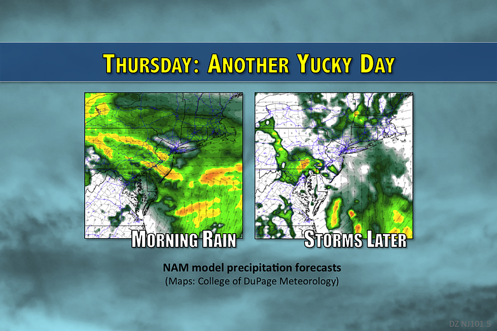
As of this writing, our storm system has already spread steady rain across the Garden State. It's going to make for a soggy Thursday morning commute, so I hope your umbrella and windshield wipers are ready.
By Thursday afternoon, the rain will break apart — so the day will not be a total washout. We might even see a few breaks of sunshine, causing temperatures to spike into the lower 70s across SW NJ.
However, the last piece of this storm system will not push into Jersey until Thursday late afternoon to evening. Combined with the warm, humid atmosphere, we'll be watching for not only scattered showers but also strong thunderstorms. The chance for severe weather (gusty winds and hail) will be greatest in South Jersey right around sunset Thursday.
Additionally, the coastal flooding threat continues Thursday, with a Coastal Flood Advisory in effect for the entire Jersey Shore. According to the National Weather Service, spotty minor flooding is possible during Thursday morning's high tide (around 7:30 a.m. along the oceanfront). More widespread minor flooding is expected along tidal waterways during Thursday evening's high tide cycle (around 8 p.m.).
The chance for scattered showers will continue Thursday night, and fog will be possible as well. Raindrops will be done falling by Friday mid-morning at the absolute latest. (Most of the state will be drying out by the time you wake up Friday.)
And then Friday should turn into a pleasant day, as skies clear through the afternoon hours and temperatures warm into the lower to mid 70s. It will be a bit breezy, perhaps. And models have been advertising an isolated shower Friday afternoon — but I don't buy any big rain impacts Friday.
So the beginning of the Memorial Day Weekend looks fantastic. The quiet, mild weather continues on Saturday, with partly sunny skies and mid 70s in the forecast.
Sunday will start off quiet. But increasing clouds will lead to our next chance of showers and thunderstorms starting around 2 p.m. Sunday. Highs will remain seasonable, in the lower to mid 70s.
Memorial Day Monday looks similar, with a partly to mostly cloudy morning and high temperatures in the lower to mid 70s. However, a cold front will sweep another round of rain through the Garden State starting around mid-afternoon Monday.
The long-range forecast keeps temperatures comfortable and seasonable, generally in the 70s. Hopefully high pressure will build in by the first weekend of June, leading to an extended stretch of pleasant and (more importantly) dry weather.
More From WPG Talk Radio 95.5 FM


