Winter Storm Warning: 6 Things to Know About NJ’s Snow
Ready or not, here it comes — New Jersey's first accumulating snow of the season arrives this weekend.
1.) Final Snow Forecast
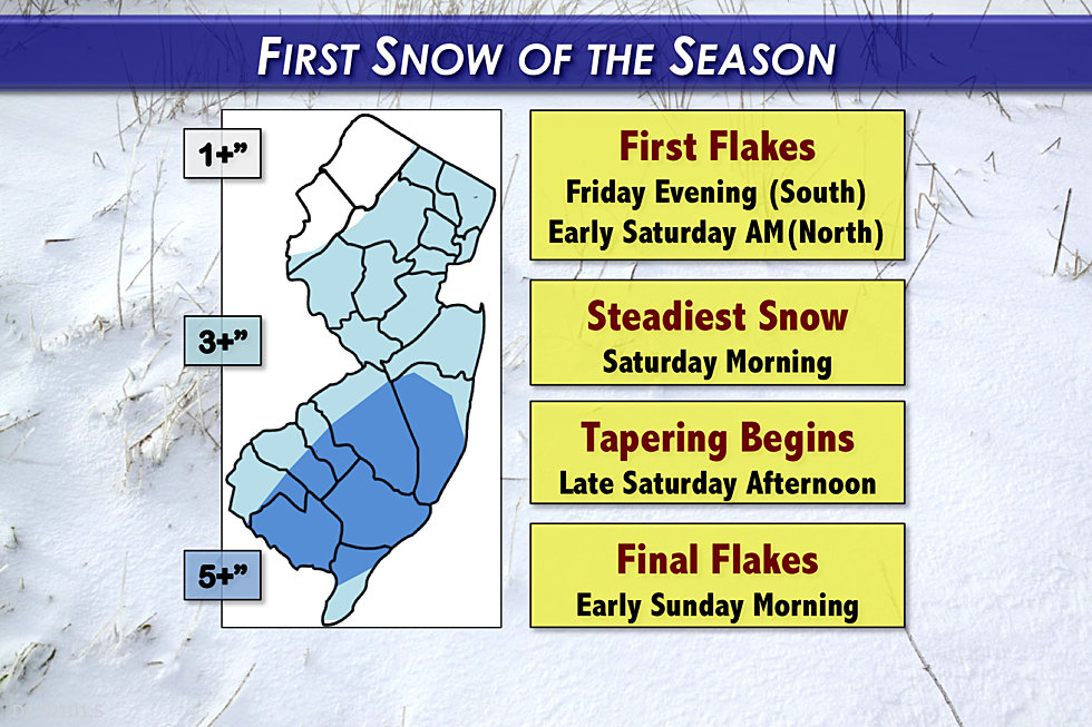
The snowfall forecast map above is the last one I will publish for this winter storm. Incredible how that little wiggle toward the west in the storm track changed our weather situation so dramatically in the past 48 hours.
Given the very latest data and model guidance, I still believe 3 or 4 inches is a good bet for most of New Jersey.
Typical of a south-to-north moving winter storm, the biggest snow totals will likely occur in South Jersey and along the Jersey Shore. (Some have called it a "South Jersey Special" — I kind of like that term!) Snowfall totals will likely be a bit greater in the dark blue area of the map above, on the order of 5 or 6 inches.
Some models have pumped out sporadically higher snowfall totals, but I just don't think we're going to see widespread 7 to 9 inch totals.
Northwestern New Jersey will fall outside of the steadiest snow bands, and so totals will be the lowest here. 1 to 2 inches will still mark the first accumulation of the season.
2.) Timeline
Light raindrops and snowflakes have already fallen in southern New Jersey. And, throughout Friday night, snow bands will continue to spread from south to north across the state. With overnight low temperatures in the 20s, it will definitely be cold enough for all-snow at the onset.
The peak of the storm comes Saturday morning, and that's when the snow on the ground will begin to pile up.
Steady snow should continue into the early afternoon hours on Saturday, with some tapering by late afternoon.
Snow showers will remain possible through Saturday night, with final flakes expected early Sunday morning. The rest of Sunday will feature sunshine, a brisk wind, and continued cold temperatures.
3.) WWA
On Friday afternoon, the National Weather Service upgraded the Winter Storm Watch to a Winter Storm Warning. Still in effect from 1 a.m. Saturday to 1 a.m. Sunday, and still covering the 8 counties along and south of Interstate 195. (Atlantic, Burlington, Camden, Cape May, Cumberland, Gloucester, Ocean, and Salem)
A Winter Weather Advisory has been posted for the central and northeastern portions of the state. The Advisory is in effect for Hunterdon, Mercer, Middlesex, Monmouth, and Morris counties from 1 a.m. Saturday to 1 a.m. Sunday. For Bergen, Essex, Hudson, Passaic, and Union counties, the Advisory is effective from 6 a.m. Saturday to 1 a.m. Sunday. An Advisory is less severe and less urgent than a Watch/Warning, and is generally issued when 3+ inches of snow is possible.
4.) The Biggest Question So Far
The most popular question of the day: Will it be slushy wet snow, or dry powdery snow?
Definitely leaning on a wetter snow. Early-season snow usually features temperatures right around or just below the freezing mark, which generally means it will be a wetter snow. That will be true throughout Saturday. In other words, great "packing snow" for snowmen and snowballs!
Not fun to shovel though. Ugh.
5.) The Biggest Impact
As with any winter storm, travel/driving is going to be the biggest impact. Roads will be wet at first, but may become snowy and/or slushy and/or icy as the snow continues to fall and the surface temperature continues to drop.
Did you know that 96% of winter storm deaths in the United States are a result of traffic incidents?
Even though this is not a "major" storm by any means, it's a good idea to stay at home on Saturday if you can. That's especially true if you are (or your vehicle) are uncomfortable driving through snow, slushy, and ice.
6.) Forecast Confidence
For the first time this week, I feel pretty comfortable with the forecast I've presented — just in the nick of time! I am still worried about 1.) whether mixing along the coast will limit snow totals, 2.) whether a dry slot (area of no-snow) will limit snow totals, 3.) how quickly the snow will stick to concrete and asphalt, and 4.) those rogue model runs that popped higher snowfall totals in the 7 to 9 inch range.
Nothing we can do about it now. The forecast is made, and snowflakes are already arriving. I feel my forecast has equal chances of busting high or low — that's the mark of a good snow forecast in my eyes. (Of course, there's no such thing as a "perfect" snow forecast — I've presented the most complete and clearest analysis I can muster.)
Be safe, be smart, and enjoy the snow! Next weather blog update scheduled for Saturday morning.
More From WPG Talk Radio 95.5 FM


