Nasty Weather for NJ Monday: Dangerous Wind, Severe Thunderstorms
Hello there, and a Happy Easter and Happy Passover to all who celebrate.
Do you remember last Thursday and Friday? The line of powerful thunderstorms that rolled through the state, delivering a brief round of intense rain, lightning, and wind? Followed by an extended period of gusty winds?
Well, hold on to your Easter bonnet, because we're about to do it again. More wind and more thunderstorms will significantly impact New Jersey from late Sunday night through most of Monday.
If you follow my forecasts, you know I do not ring alarm bells unnecessarily — I am very careful and deliberate about the words I use in my forecasts. So when I use descriptors like nasty and dangerous in a weather blog headline, it is a purposeful attempt to capture as much attention as possible.
On the one hand, we are now entering the fourth week of New Jersey's Stay at Home order, in the fight against COVID-19. That means during the impending storms and wind, most people will be stuck at home, inside a sturdy building, and off the roads. Great.
However, we can't be complacent. There are so many news headlines and so much general anxiety out there right now — but the weather doesn't stop. When Thursday's squall line rolled in, I was truly dismayed at the number of casual walkers and outdoor worker who had to run for cover when the sudden (yet well-forecast) downpour and burst of wind arrived. Do not let that happen again, please.
Let's dive into the details.
The Setup
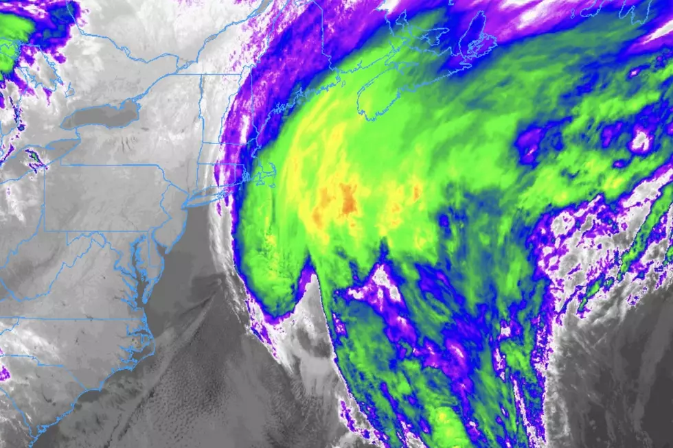
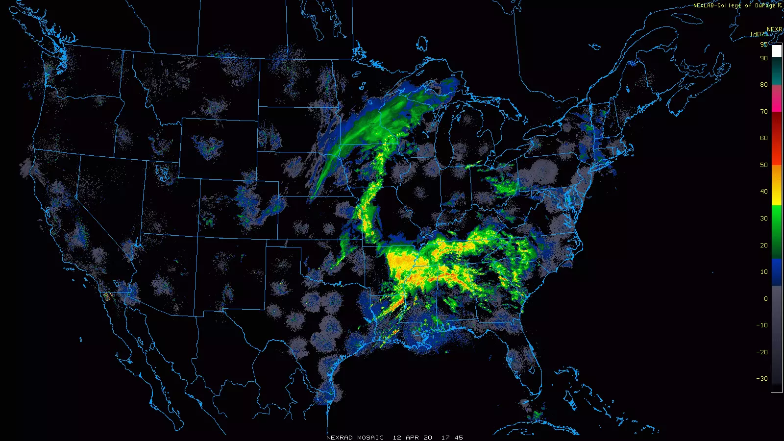
As of Sunday afternoon, a potent storm system is centered over the Southern Plains (Oklahoma-Arkansas-Louisiana). A severe weather outbreak is currently underway across the Gulf Coast states.
That area of low pressure will jog north Sunday night, with the center passing across the Great Lakes around midday Monday. Even though it's not a "direct hit" for the Garden State, that storm track is a very important element of this forecast — it means we're facing a one-two punch of dynamic weather.
First, a warm front will lift from south to north through New Jersey late Sunday night. A few things to know about the warm front:
1.) As the name implies, temperatures will warm, probably spiking into the 70s for much of NJ on Monday.
2.) Humidity will be on the rise too.
3.) The wind will kick up dramatically.
4.) The lift from that warm front will spark an extended period of driving rain.
5.) The juicy atmosphere will be primed for even stronger thunderstorm cells later on.
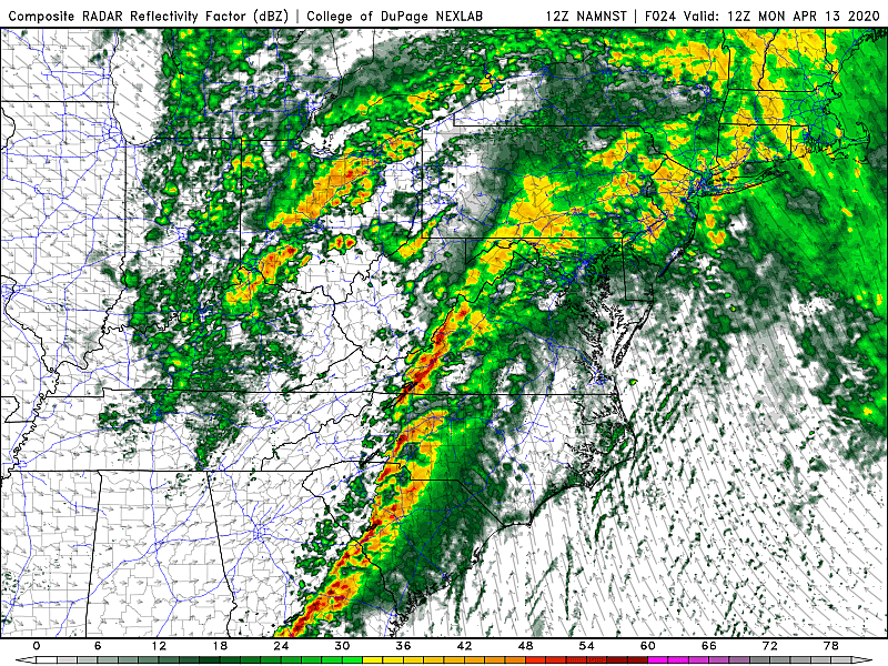
Second, a cold front will pass from west to east Monday afternoon and evening. That front will push through a round of strong to severe thunderstorms — the grand finale to a very active day of weather.
Timeline
This is not just your run-of-the-mill rainy, windy day. Here's how this extended period of downpours and gusts are forecast to play out for New Jersey.
—Sunday evening (6 p.m. to Midnight)... Splotches of light rain (i.e. passing showers). Becoming breezy, with regular gusts over 20 mph (inland) and 30 mph (coast).
—Early Monday morning (Midnight to 5 a.m.)... Conditions continue to go downhill, as rain intensity and spread intensifies. Wind picks up too, with gusts over 30 mph (inland) and 40 mph (coast).
—Monday morning (5 a.m. to 10 a.m.)... Periods of heavy rain continues. Probably the biggest contribution to storm total rainfall will happen in (or just after) this window. Winds will howl above 40 mph (inland) and 50 mph (coast).
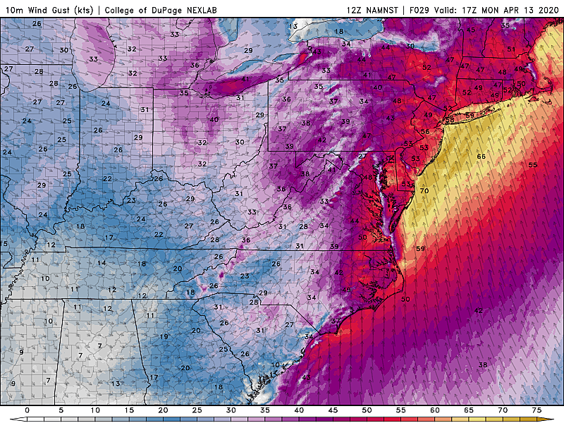
—Monday midday (10 a.m. to 2 p.m.)... Still raining. Peak ambient wind gusts are forecast to occur here. Top gusts will be about 50 mph (inland) and 60 mph (coast).
—Monday afternoon and early evening (2 p.m. to 6 p.m.)... A line of thunderstorms will cause a brief period of intense rain, wind, and severe weather. Background wind still quite gusty too (pre cold front), with some 50+ mph gusts. Depending on the exact timing, your evening commute could be heavily impacted.
—Monday evening (after 6 p.m.)... New cooler, drier air mass arriving. Lingering showers end and skies clear. West-northwest wind will gust to about 30 mph — we'll call that breezy overnight.
Impacts
In order of likelihood and severity, here are the most significant weather impacts expected in New Jersey from this stormy setup...
—Thunderstorm Wind... The round of rain Monday morning and (more likely) the grand finale thunderstorms Monday afternoon will open the door to some very strong, potentially damaging wind. Thursday's top wind gust in NJ was 71 mph — that may be equalled or beaten by our next round of stormy weather.
—Non-Thunderstorm Wind... Once again, the non-thunderstorm, ambient, pressure gradient force wind will be quite ferocious too. Likely peaking around midday Monday, gusts over 50 mph (inland) to 60 mph (coast) are expected. Tree and roof damage is possible. Scattered power outages are likely. Garbage cans will be blown far, far away.
—Driving Rain... Models suggest a widespread 1 to 2+ inches of rain will fall, over a period of about 18 hours. Flash flooding of roads and other low-lying roads is possible. (Remember, sometimes flooding just looks like a big puddle, but can be an extreme hazard.) Streams and creeks will run high and fast too.
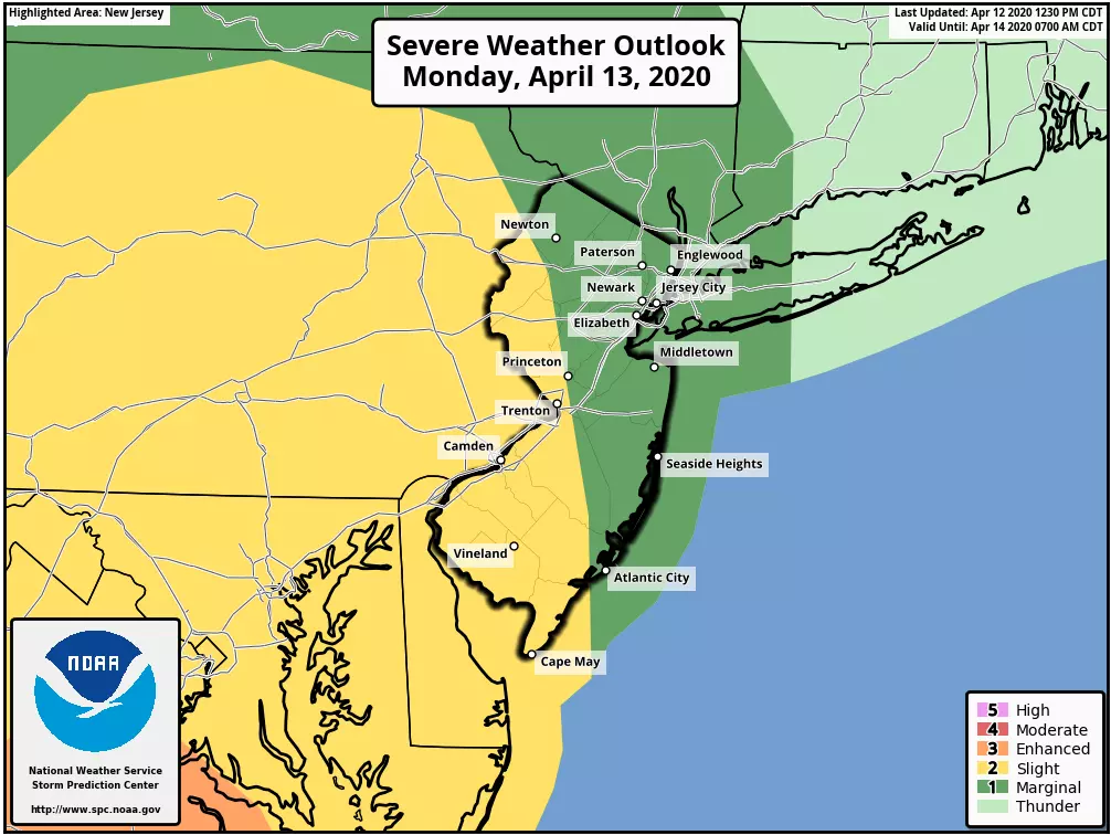
—Isolated Tornado... As we saw nine times in 2019 alone, tornadoes do happen in New Jersey. Linear thunderstorm modes (like this one) aren't necessarily conducive to long-track, strong tornadoes. But we'll still have to watch for quick spin-ups, especially given the turbulent wind shear.
—Hail... A cold upper atmosphere sets the scene for hail, chunks of ice that get caught in strong updrafts (vertical wind) before crashing down to earth. Severe or damaging hail is very rare in New Jersey, but it is on the table for Monday
—The Coast... Even though the ambient winds will blow out of the southeast — an on-shore wind — they won't carry enough ocean water toward the Jersey Shore to warrant a significant coastal flooding threat. We're also not in a particularly high astronomical high tide cycle right now, which works in our favor. In fact, guidance moreso points toward the risk for a blowout low tide Monday morning, as water levels run about 2 feet lower than usual.
Warnings
A High Wind Warning has been issued for central and southern New Jersey, from 6 a.m. to 7 p.m. Monday, calling for wind gusts between 50 and 70 mph. Counties in the warning include Atlantic, Burlington, Camden, Cape May, Cumberland, Mercer, Middlesex, Monmouth, Ocean, and Salem.
An on-the-fence High Wind Watch continues for northeastern New Jersey, covering the possibility of damaging 70mph wind gusts between 6 a.m. and 6 p.m. Monday. This watch will flip to either a warning (likely) or an advisory in the coming hours. Counties in the watch include Bergen, Essex, Hudson, Passaic, and Union.
A less-severe Wind Advisory covers northwestern New Jersey, from 6 a.m. to 7 p.m. Monday, calling for wind gusts up to 55 mph. Counties in this advisory include Hunterdon, Morris, Somerset, Sussex, and Warren.
A Storm Watch, Gale Warning, and Small Craft Advisory have been issued for the ocean waters off the NJ coast. 55+ knot winds and 20+ foot seas are likely off-shore.
As of this writing, no coastal flood warnings or advisories have been issued for the Jersey Shore.
Bottom Line
For almost 24 hours, from late Sunday night through Monday evening, our weather is going to be downright nasty. For all intents and purposes, our weather impacts will be similar to that of a tropical storm — peak wind gusts over 60 mph, wind-driven downpours, and the potential for severe weather. The strongest winds and loudest thunderstorms will occur during the day Monday.
The coronavirus stay-at-home routine will help keep New Jerseyans safer from these powerful springtime storms. But that doesn't mean we all can just ignore the weather — please make sure your family and friends know that dangerous conditions will be present throughout Monday.
My next weather blog will be posted early Monday morning. I will be on the air from 5 a.m. to 7 p.m. Monday with the latest weather forecast information. And our entire weather, news, traffic, digital, and programming teams are at the ready too.
Be smart, be safe, and be healthy. And again, from my family to yours, a happy holiday.

More From WPG Talk Radio 95.5 FM