Wednesday NJ weather: Chilly morning, mild afternoon, smoky sky
The Bottom Line
Cooler-than normal temperatures. Dry air and dry weather. A smoky sky. And a churned up ocean, as the tropics remain very active.
That describes almost every day of the next week — save for Thursday, which will be slightly warmer and wetter. In particular, as the forecast for the final weekend of summer shapes up, it is looking quite fall-like.
Wednesday
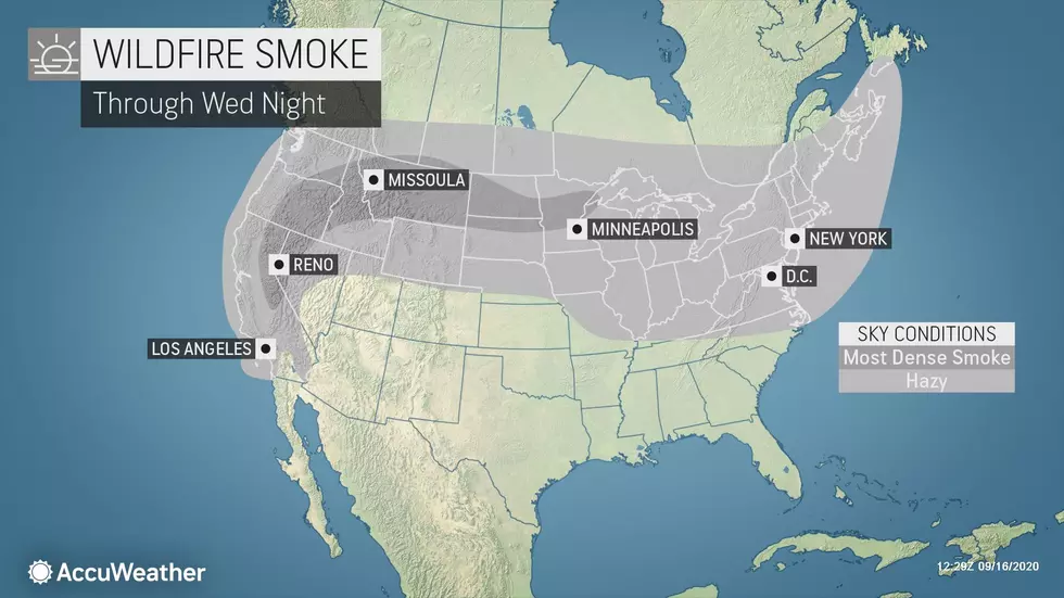
Once again, smoke from the western U.S. wildfires will be about 3-4 miles overhead, causing the sky and sun to appear hazy and washed-out. Still no smoky smell or air quality controls. However, that smoke did keep temperatures a few degrees cooler than expected on Tuesday. So I've adjusted things to compensate, as the smoke particulates will be with us for at least a few more days.
You may be reaching for the jacket again, as Wednesday morning has become even colder than Tuesday morning. Temperatures are mostly in the 40s, with slightly warmer 50s in urban and coastal areas. At least there's no wind.
Hazy sunshine will meet dry air and dry weather Wednesday. Afternoon temperatures will be slightly warmer, in the lower 70s. That is still about 5 degrees below seasonal norms.
A high risk of dangerous rip currents continues along the Jersey Shore, with 4 named tropical systems churning up the entire Atlantic basin. The ocean will be angry. And it is stronger than you.
Clouds will slowly increase Wednesday night. And it won't be as chilly as the last two nights, as thermometers only bottom out in the upper 50s to around 60 — typical for this time of year.
Thursday
As I mentioned above, Thursday is the one exception to an overall cool, dry, autumnal weather picture. Skies will turn mostly cloudy, with a hint of humidity in the air. It will be our warmest day of the week, with high temperatures in the mid to upper 70s. So far, so good.
The big weathermaker to watch will be the remnants of Hurricane Sally, which is making landfall along the Gulf coast Wednesday morning. The center of that remnant low will track over the Carolinas — well to our south. However, depending on the exact storm track (which is dependent on the strength of our dome of high pressure), some rain could very well drift into New Jersey. Especially southern New Jersey.
But raindrops are not a sure bet for everyone. It really depends on which forecast model you agree with. The NAM shows a wet Thursday afternoon and night for the southern half of the state. The GFS model is much drier, with only stray showers lapping up against far southern New Jersey. I'm leaning toward the drier solution. But I've included a chance of more widespread rainfall in my on-air forecast, just in case. In either case, there won't be anything severe or overly heavy.
Friday
A cold front passing through New Jersey early Friday morning will help push away the rain and Sally's remnants. It will also kick up a 20+ mph north-northwest wind for the first half of the day. Friday morning will be cloudy, with a lingering shower possible. And then Friday afternoon should be brighter — possibly even sunny in NW NJ. However, there is a chance that front stalls just south of us, slowing any clearing action for southern, coastal, and maybe central New Jersey.
Friday will definitely bring a return of unseasonably cool, fall-like temperatures. High temps will only reach the mid 60s.
Saturday, Sunday, & Beyond
The 60s will carry through the weekend. It will be pleasant and dry, with partly to mostly sunny skies for both Saturday and Sunday. Mid 60s will be about 10 degrees below normal for the final days of summer.
The autumnal equinox, the official start of fall, arrives on Tuesday at 9:30 a.m. And we'll keep a relatively dormant, mainly dry, generally cool forecast going through the end of September.

More From WPG Talk Radio 95.5 FM


