‘Major’ flooding, power outages: Heavy rain and wind hit NJ Tuesday
The Bottom Line
Our big, bad, multi-hazard, high-impact storm arrives in New Jersey on Tuesday. Over the past few days, I have called it a monster. And massive. And dangerous. And potentially deadly.
All of those descriptions still very much apply. I am glad almost everyone is taking this storm threat very seriously. Flash flooding, river flooding, wind damage, power outages, and beach erosion remain big concerns.
While Tuesday starts off quiet and dry, weather conditions will go progressively downhill throughout the day. You will need the umbrella by the afternoon. By the evening hours, around 6 p.m. to 2 a.m. — the peak of the storm's impacts on NJ — that umbrella might blow away.
Let's take one more stab at Tuesday's stormy forecast, including a detailed look at impacts, advisories, and timing. And let's look ahead at our next storm system, set to arrive at the end of the week.

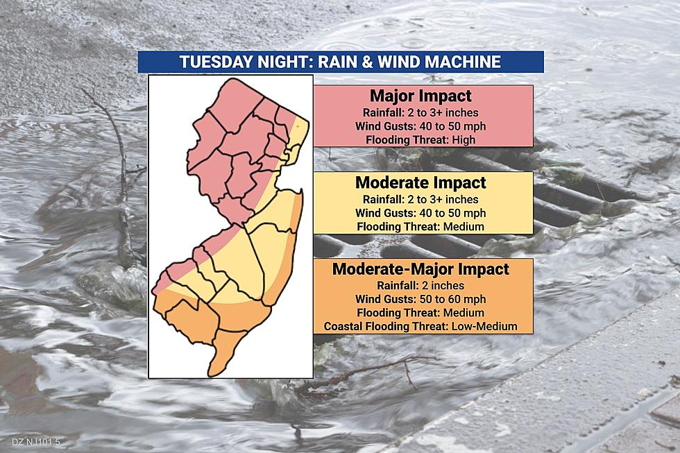
Storm Impacts: By the Numbers
Rain... The total rainfall forecast ranges from just under 2 inches (in SW NJ) to just over 3 inches (in NE NJ). That is a lot of water. The risk of flash flooding (roadways, low-lying areas, etc.) is pretty high, due largely to our already-saturated ground. River flooding is even more precarious, in the moderate to major category, due to rain runoff and significant snowmelt.
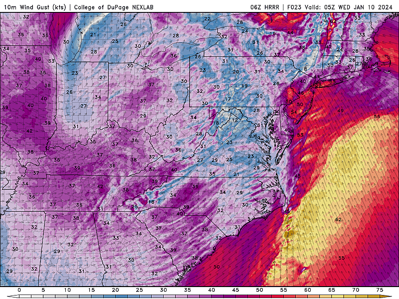
Wind... Top wind gusts will likely reach 40 to 50 mph across inland New Jersey, and even stronger 50 to 60 mph near the coast. That is a lot of wind. Enough to cause downed trees and branches. Widespread power outages are possible during the height of the storm.
Storm Surge / Coastal Flooding... Not the biggest impact here — this is not a nor'easter or coastal storm — but still worth mentioning. 1 to 2 feet of surge may cause minor category coastal flooding at high tide Wednesday. (Note: The Delaware River is tidal, but faces an even greater flooding risk due to rain and runoff.)
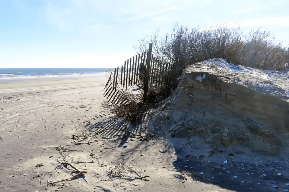
Ocean Waves / Beach Erosion... The ocean is going to be all churned up due to heavy winds. 10 to 20 foot ocean waves will batter beaches, potentially causing significant erosion.
Snow... This is not a "snow" storm for the vast majority of New Jersey. Sussex and Warren counties could see a brief period of wintry mix at onset Tuesday midday. But little to no accumulation is expected, and it will flip to all-rain by mid-afternoon.
Temperatures... Expect 40s Tuesday afternoon, climbing into mid-upper 50s around Midnight, then settling back in the 40s for Wednesday.
Phase 1: Just Wet (Tuesday Daytime)
As of this writing (7 a.m.), all's quiet across New Jersey. Temperatures are starting in the 20s and 30s, and radar is all clear. Clouds are filling in at this time.
Initial showers will arrive from the west by mid-late morning (8 a.m. to 11 a.m.) Light and scattered at first, before rainfall becomes steadier and heavier.
The afternoon will become increasingly wet, as bands of moderate to heavy rain push in. Nothing crazy yet. Just watch for wet roads, big puddles, and reduced visibility through the start of the evening commute.
Phase 2: The Brunt of the Storm (Tuesday Evening)
Again, I have cast a wide window for peak storm impacts between 6 p.m. and 2 a.m. That entire time will not necessarily be "nasty". But conditions will become challenging and even dangerous for a few hours in that time frame.
The heaviest rain will fall during the Tuesday evening hours, possibly topping an inch per hour in spots. That will lead to a rapid increase in ponding and flooding issues. (I expect 60 to 80 percent of this storm's rainfall to occur in this "brunt" period.) The biggest downpours will likely occur to the north and west.
In addition, the wind will really fire up Tuesday evening too. Those top gusts of 40 to 60 mph will reduce visibility even further, lead to driving difficulties, bring down trees and branches, damage shingles and siding, and cause widespread power outages. The most ferocious winds will be to the south and along the coast.
After the big deluge exits, rain will end completely shortly thereafter. It will feel like the faucet is turned off suddenly, as we begin a drying trend by daybreak Wednesday.
Phase 3: Residual Issues (Wednesday and Beyond)
Although Wednesday will be mainly dry, I can't rule out a shower. In fact, some models show one final compact area of rain traversing New Jersey around mid-morning.
It will also remain windy on Wednesday, with top gusts still near 40 mph. Expect residual power outages.
And while areas of flash flooding will slowly subside, the river flooding will only get worse on Wednesday. The Passaic River at Pine Brook, for example, is expected to surpass Major flood stage in the middle of the afternoon, cresting at 21.9 feet Wednesday evening. (For reference, that section of the Passaic reached 21.5 feet after the mid-December storm — this one is forecast to be a few inches higher.)
The Delaware River is expected to crest above Moderate flood stage early Wednesday afternoon. And again Thursday afternoon.
Along the Shore, oceanfront high tide will be around 6am, with back bays cresting up to three hours later. Widespread minor category flooding is expected for at least that early high tide cycle.
It may take several days for floodwaters and river levels to fully subside.
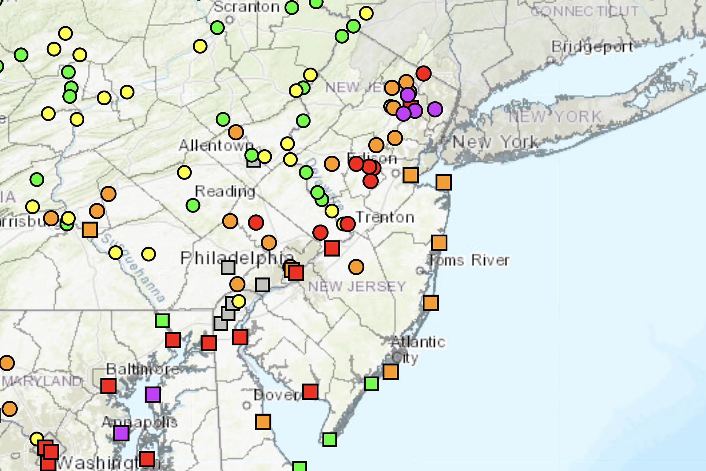
Advisories
Given the multiple hazardous conditions that may occur simultaneous, it should be no surprise the National Weather Service has issued a fleet of warnings and advisories:
A Flood Watch covers all 21 counties of New Jersey, from Tuesday afternoon to Wednesday afternoon. This cautions of both flash flooding, due to downpours, and river flooding, due to runoff.
Don't travel during the height of the storm, if possible. Remember to never attempt to drive, swim, or walk through flooded areas. It is both dangerous and disgusting. Turn around, don't drown.
A High Wind Warning is in effect for the Shore (from Monmouth to Cumberland counties), from 6 p.m. Tuesday to 4 a.m. Wednesday. Wind gusts may exceed 60 mph, blowing down trees and power lines.
A less-severe Wind Advisory is posted for the rest of the state, as gusts may hit 40 or 50 mph.
Secure loose outdoor articles such as garbage cans before the storm. Keep your phone charged and flashlight handy, in case of power outage.
A Coastal Flood Warning for the overnight high tide cycle along the Delaware River (from Mercer to Salem counties), expected to top Moderate flood stage. (This warning will likely be extended, as several more rounds of flooding are expected along the Delaware.)
A Coastal Flood Advisory has been issued for most of the Jersey Shore (down to Ocean County), calling for minor flooding of tidal waterways during high tide Tuesday night to Wednesday morning.
Although there are no official advisories issued for high surf or rip currents, ocean waves are going to be huge as this storm passes through. Ocean wave heights of 10 to 20 feet are likely just off-shore. If those waves break on the beaches, significant erosion may occur.
What's Next?
There is one more precarious piece to this storm's story.
Our next storm system is set to arrive Friday night through Saturday morning. Another rain maker, it is forecast to produce up to an inch of rain over New Jersey. There could be some wind too. But it will not be as strong nor as soaking wet as Tuesday night's storm.
We could run into problems if rivers, streams, and creeks are not able to fully recede by then. It's a real possibility that those flood-prone rivers (the Passaic, the Raritan, the Delaware, and associated tributaries) rise again with additional rainfall.
Even though one-inch rain events do not often cause significant flooding alarm bells to ring, we will have to watch this one very closely.
Behind that system, temperatures chill out big time over the weekend. A blast of arctic wind will send thermometers tumbling. While early Saturday morning (during the rain) will be near 60 degrees, Sunday may stay below freezing all day.
Long-range guidance does hint at another storm around Tuesday of next week. It would be cold enough for an all-snow or mainly-snow scenario. But there is zero agreement among forecast models at this point. The Euro shows a powerful nor'easter dumping snow on New Jersey. The GFS shows a whisper of a storm, maybe putting an inch of snow on the ground. Let's deal with Tuesday night and Friday night, and then we'll see what next week might bring.
This will be my final weather blog forecast before the big storm starts to soak and blow. Our news, weather, traffic, talk, and digital teams are ready to cover this storm from every angle, no matter what Mother Nature throws our way. Thanks for staying with us. Please stay smart and be safe out there — this storm means business.
BEEP BEEP BEEP: These are the 13 types of Wireless Emergency Alerts auto-pushed to your phone
Gallery Credit: Dan Zarrow
Dan Zarrow is Chief Meteorologist for Townsquare Media New Jersey. Follow him on Facebook for the latest forecast and realtime weather updates.
LOOK: Biggest snowfalls recorded in New Jersey history
Gallery Credit: Stacker
More From WPG Talk Radio 95.5 FM