NJ temps soar into the 60s, punctuated by showers and t-storms
The Bottom Line
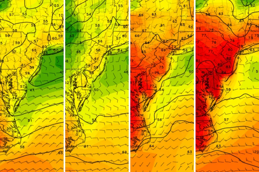
Frosty, freezing, frigid February?? Ha! Unseasonable warmth is the name of the game, as high temperatures soar into the 60s. Tuesday will likely be New Jersey's 3rd 60+ degree day of 2024. And Wednesday will probably be #4.
However, the rising temperatures come alongside an increase in humidity and rain chances too. While most of Tuesday looks good, showers and thunderstorms ramp up through the evening and overnight hours. Wednesday stays unsettled, before a cold front delivers one final burst of rain and wind Wednesday evening. While there is no "washout" weather expected here, rumbles of thunder, storm-related wind gusts, and pockets of heavy rain are all possible.
Blustery weather returns on Thursday, making for a cold end to February. But temperatures should moderate heading into the first weekend of March. With a smattering of rain chances, and very little (if any) opportunity for snow.
Tuesday
Nice and warm, that's for sure. The morning hours will be chilly enough for a jacket, with temperatures mainly in the 30s. But by the afternoon, most of New Jersey will bask in widespread lower 60s. (Cooler 50s to the north and along the coast, but that is still unseasonably warm for late February.)
We will squeeze out a fine afternoon, although skies will progress from partly sunny to mostly cloudy.
Two more important notes about Tuesday. First, smoke from wildfires across the southern United States will enter New Jersey's atmosphere. You may notice a haze in the sky, and air quality may be degraded. Second, pollen season has begun, as this week's warmth sparks the spring bloom and sends the allergy meter soaring.
Starting around 5 p.m., scattered showers and thunderstorms will arrive from the west. Yes, I said thunderstorms — which could contain some localized downpours and bursts of wind through Tuesday evening. Everyone in the state will likely get wet eventually through Tuesday night.
At least we will hold on to mild temperatures overnight, with lows only dipping into the 50s.
Wednesday
Still warm, but not very nice.
Wednesday will be an unsettled weather day, with a few hit-or-miss showers through the morning and early afternoon hours. Skies will be cloudy. But temperatures will once again aim for the 60-degree mark.
A strong cold front will arrive in New Jersey early Wednesday evening. And along with it, one more push of heavy rain and wind. I will put a time window of 5 p.m. to 9 p.m. for that nasty weather.
Behind the front, temperatures will plummet rapidly. If we end up in the 20s as expected Thursday morning, that could set up a "flash freeze" situation where anything still wet will ice over. There will be some wind to help with evaporation. But that wind will also produce a biting wind chill Thursday morning.
Thursday
Back to blustery. Thursday will be an unseasonably cold day, with high temperatures barely into the lower 40s. It will be mostly sunny and dry. A chilly breeze will blow out of the west-northwest, gusting to about 30 mph. Bright, but not very comfortable.
Friday
Just like that, temperatures will moderate again for the first day of March. (As we have discussed, this routine of "bouncing" temperatures is a very springlike phenomenon.)
Highs on Friday should reach 50 degrees or better for most of the state. There will be a chance of showers Friday night, although that damp forecast is not a sure thing.
The Extended Forecast
The forecast for the first weekend of March is hazy, with different solutions depicted by the GFS (cloudy and drizzly) vs. the European (sunny and warming) models. I'll go with middle ground for now, 50s and mostly cloudy skies. And we'll grind out the details of any potential raindrops later.
The long-range forecast still shows no threat of wintry weather for the next 7 to 10 days, at least.
New Jersey's St. Patrick's Day Parades 2024 (by date)
Gallery Credit: Dan Alexander
2024 Seaside Heights Polar Bear Plunge raises $2.75M
Gallery Credit: Andrew Miller/For New Jersey 101.5
More From WPG Talk Radio 95.5 FM


