NJ Weather: Warming Up a Bit, Rain Chance to Kickoff Weekend
The Bottom Line
It has been a pretty boring week of weather so far. The entire month of November has been quiet and dry, in fact. The long stretch of rain-free weather is getting a bit concerning — about 44 percent of NJ is now in "Abnormally Dry" status. That is not officially "drought" yet, but that would be the next step.
There are two chances of rain coming up: Friday night into Saturday morning, and then next Tuesday into Wednesday. Meanwhile, temperatures will fluctuate from seasonable on Wednesday, to mild on Thursday and Friday, to chilly again for the weekend.
Wednesday
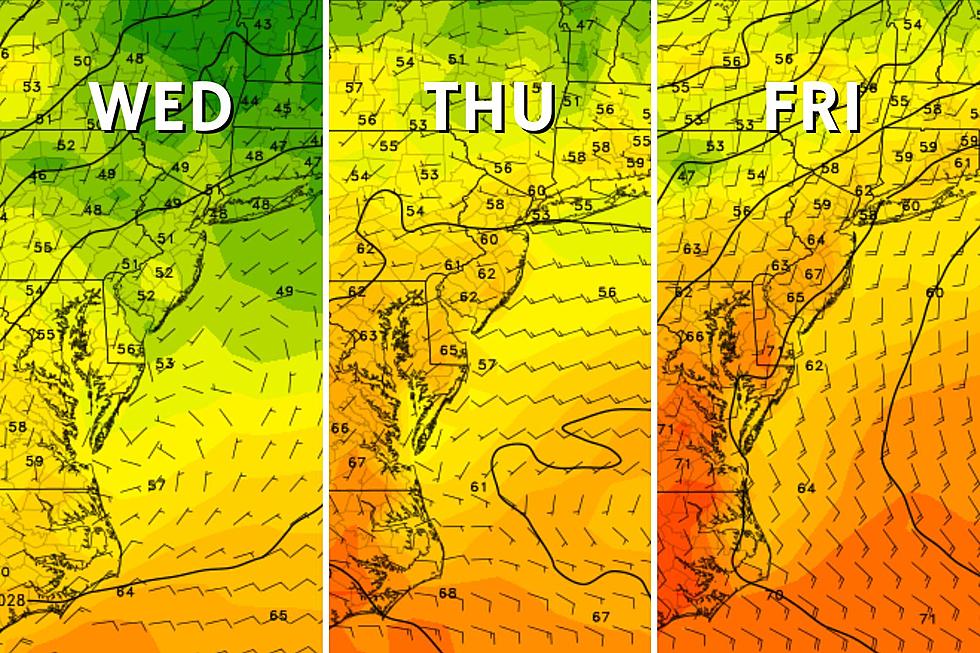
Temperatures on Wednesday will be similar to those on Tuesday, with lighter winds and less sun.
We are starting the new day frozen across most of New Jersey, with most temperatures in the 20s and 30s. While Wednesday begins with sunshine, substantial cloud cover will move in through the midday and afternoon hours. While initially, it will be high clouds that just "filter" the sunshine, I think cloud cover could get thicker and a bit greyer later on.
Regardless, it should be a decent, dry, seasonable mid-November day. High temperatures will reach the mid 50s or so.
Skies will clear out again Wednesday night, allowing temperatures to dip into the 30s. Frost is likely for the interior of New Jersey.
Thursday
Quite possibly the nicest day of the week.
Thermometers will moderate nicely into the lower 60s by Thursday afternoon, with plentiful sunshine and a light southwest breeze. No complaints whatsoever — it should be a beautiful fall day.
Friday
Most of Friday looks good too. Especially since it will be the warmest day of the week.
Skies will turn mostly cloudy Friday morning, with sunshine becoming even more limited through the afternoon. But high temperatures in the mid to upper 60s sound good to me. We could even touch 70 in a couple places in South Jersey on Friday.
Eventually, a coastal storm approaching from the southeast and a frontal boundary coming in from the west will increase rain chances. A couple forecast model runs have put an isolated shower over New Jersey starting late Friday afternoon. But any "main event" period of steadier rain will hold off until late Friday night, closer to Midnight.
Saturday
There really are no alarm bells to ring regarding our next storm system setup. No flooding threat, no severe weather, and nothing wintry. Just some spotty showers, that may linger until as late as Noon on Saturday.
While early Saturday morning may stay close to 60 degrees, temperatures will start to tumble through the day. So Saturday afternoon will turn sunny, but also breezy and colder. Wind gusts may hit 30 mph as that new air mass "whooshes" into New Jersey.
Sunday & Beyond
It only gets colder, folks.
Sunday will be sunny, but blustery as that brisk west-northwest wind will continue to blow. High temperatures will sink to the lower 50s.
Monday looks like the bottom of the barrel, the coldest of the bunch, with highs only in the mid 40s.
The next tricky piece of the forecast comes from a storm system pushing into the Northeast in the Tuesday-Wednesday time frame. Concrete details are still sparse a week in advance. I previously declared this setup "worth watching". And I maintain that concern for three reasons:
1.) Heavy rain is on the table. Yes, we need a good soaking. But any significant rainfall on Wednesday — one of the busiest travel days of the year — would snarl road/rail traffic and wreak havoc on air travel.
2.) Wet snowflakes are a possibility for northwestern New Jersey. I highly doubt we are talking about any significant accumulations. But it is significant because of the timing and because it could be the state's first snow showers of the season.
3.) If you are traveling north for the Thanksgiving holiday — meaning New York State or New England — you may run into some significant wintry weather problems from this storm.
We will continue to watch next week's situation carefully, and you should too.
LOOK: Baby names losing popularity in the 21st century
Gallery Credit: Stacker
19 Items Absolutely Banned from Checked Bags at the Boise Airport
Gallery Credit: Michelle Heart
More From WPG Talk Radio 95.5 FM


