NJ’s big storm over, rivers still rising, another storm late week
The Bottom Line
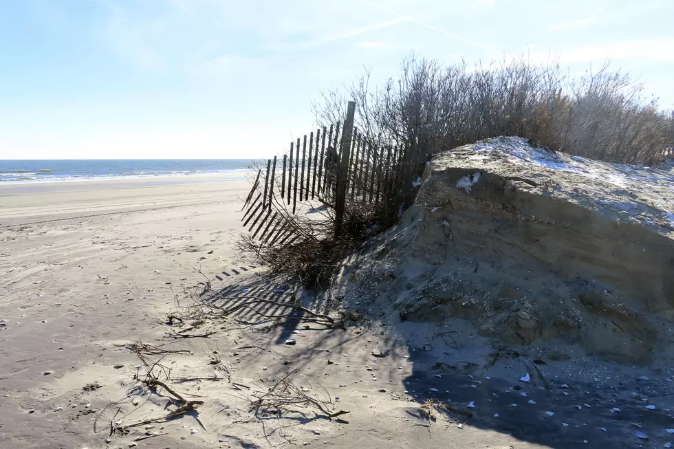
Well, that was a storm. By the numbers, things played out very close to the forecast. Top rainfall over 4 inches in North Jersey. Top wind gust 72 mph at Island Beach State Park. Top snow total about an inch at High Point, Sussex County.
Even though the storm departed early Wednesday morning, you will still encounter lots of residual flooding issues, road closures, and power outages.
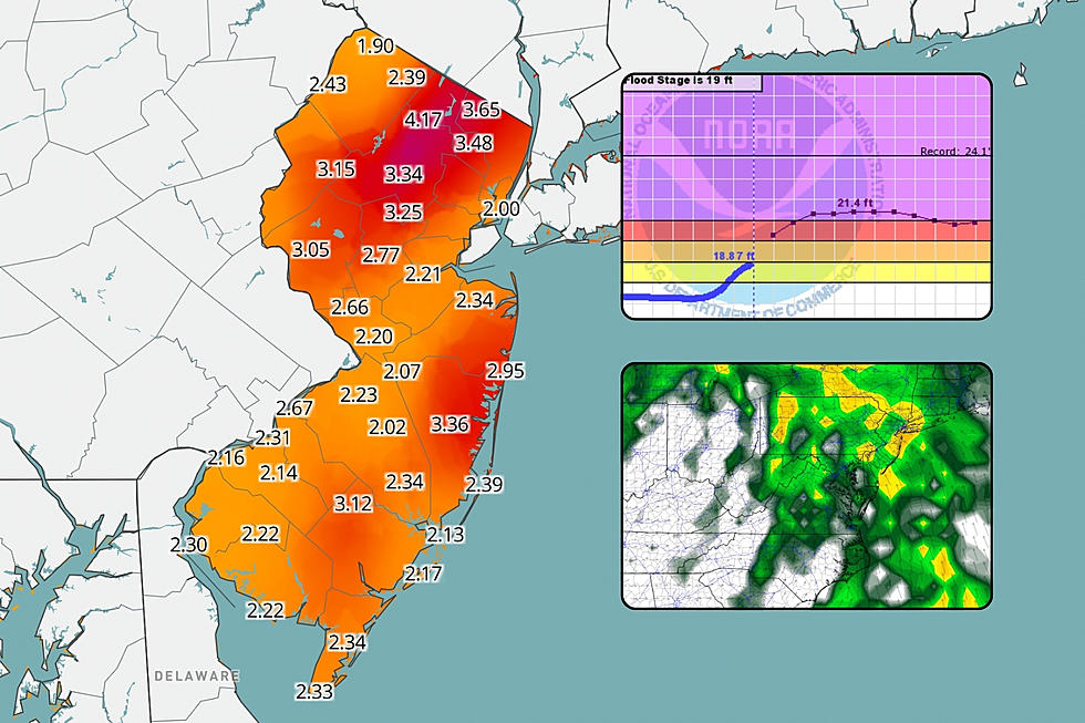
The river flooding threat is especially precarious, as all the rainwater and snowmelt runs off into New Jersey's waterways. Several rivers, streams, and creeks are under Flood Warnings, as Moderate to Major category flooding is expected. More serious water inundations are coming.
Although spotty rain will wrap up Wednesday morning, the pressure gradient remains. That means wind, potentially gusting to 40 mph through the afternoon.
There is another storm system looming at the end of the week, with a threat for 40+ mph winds and an inch of rain.
A big cooldown this weekend could set the scene for some snow next week.

The Flooding Situation
The most important point I want to make: Rivers have not crested yet. All that rainwater and snowmelt has to go somewhere. And runoff takes time to work downstream.
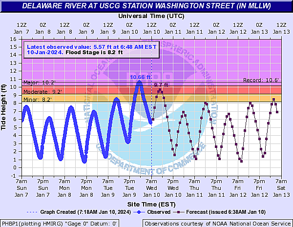
The most impressive statistic I have found so far: The water level gauges along the lower Delaware River apparently hit record flood levels at high tide early Wednesday morning. The gauge attached to the Burlington Bristol Bridge hit 11.99 feet — besting the crest of 11.94 feet during Ida in September 2021, and the 11.69 foot peak during Sandy in October 2012.
The gauge at the Coast Guard Station in Philadelphia hit a record 10.66 feet, a quarter-inch higher than the 10.64 foot crest during Sandy.
The following major NJ waterways have already exceeded "Major" flood stage:
—Millstone River
—Raritan River
—Saddle River
—Delaware River (at high tide)
The following major NJ waterways are forecast to crest above "Major" flood stage soon:
—Passaic River
—Pompton River
Numerous other waterways are at or will reach the "Moderate" or "Minor" flooding categories.
Coastal flooding is also a concern for Wednesday morning's high tide cycle. Minor to moderate flooding of tidal waterways is now expected for Monmouth and Ocean counties. Atlantic and Cape May counties should hold to minor flooding, at the worst.
Those Major and Moderate flooding benchmarks are big deals. They are set when river levels at specific points are expected to rise to levels that threaten roads, property, or lives. Water inundation issues will only get worse before they get better. And floodwaters will take many days to fully subside.
Wednesday
As of this writing (7 a.m.), there are still some spotty areas of rain around the state. Those exit by late morning, and we will be left with a mainly dry day.
In addition to the mounting river flooding threat, the wind is going to pick up again Wednesday. Gusts to 40 mph are possible from late morning into the afternoon. In fact, the National Weather Service issued a Wind Advisory for most of the state. Not as strong and destructive as Tuesday night's wind, but still noticeable.
We will see partial sunshine break out Wednesday. Temperatures will fall off from the lower 50s early on, settling into the mid 40s or so by late afternoon.
Wednesday night will be partly cloudy, with low temperatures around the freezing mark in the lower 30s. Some wet surfaces and puddles may freeze, so watch for slippery spots. Any little breeze will dip the wind chill ("feels like" temperature) into the 20s overnight.
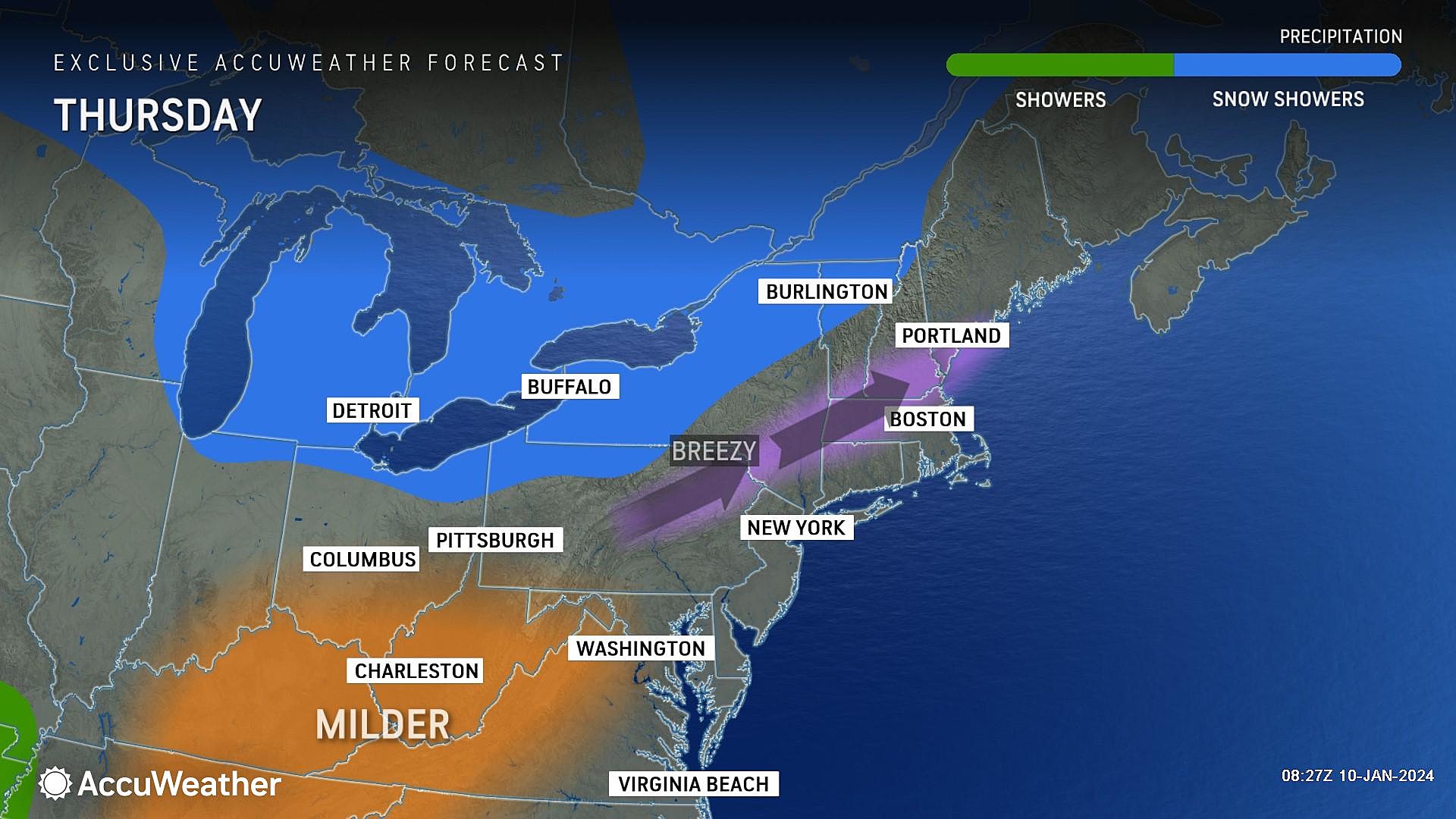
Thursday
All things considered, Thursday's forecast reads like a decent January day.
It will be breezy. But we should see substantial sunny periods, mixed with some fair-weather clouds. It will be dry. And high temperatures should reach the mid 40s — that is a bit above normal for mid January. (We are approaching the "dead of winter" — the average coldest time of the year.)
Despite the fair weather, river flooding issues will continue to be a concern.
Friday
Friday will once again hit the mid 40s in the afternoon, as skies progress from sun to clouds.
And then, here comes our next storm system.
This is going to be a shorter and less impactful period of wet weather. It's a sunset to sunrise event — the window for rain returning to the Garden State looks to be about 5 p.m. Friday to 5 a.m. Saturday.
Rainfall totals may exceed an inch in spots. Wind gusts to 40 mph are possible too.
Usually this magnitude of storm would not warrant extra attention. However, because the soil is saturated and rivers are running high, I am concerned about a reemergence of flooding.
While a quick hit of wintry mix is possible in far northwestern New Jersey only, this will be another rain storm. Temperatures may rise to around 60 degrees early Saturday morning.
Saturday
Residual showers wrap up early Saturday. And then we face a big blustery cooldown.
Winds on Saturday may gust to 40 or 50 mph, out of the west, as arctic air builds into New Jersey. Temperatures will plummet from the 50s in the early morning hours to the 30s by late afternoon.
Overnight lows will drop into the 20s. Reminding us that it is, in fact, still the winter season.
Sunday & Beyond
If you have been craving cold air, here you go. Sunday's high temperatures will be in the 30s, with a continuing biting breeze. Skies will be partly sunny, with no precipitation expected.
Long-range models continue to hint at another disturbance riding into New Jersey in the Monday-Tuesday time frame. How big and impactful that storm system will be depends upon which model you believe. The GFS shows a quick inch of snow accumulation. The Euro pushes in a powerful nor'easter, with the potential for 6+ inches of snowfall for part of the state.
I'm not sure which one I am more tempted to believe at this point. Hopefully once we clear Friday night's storm, we'll have a better picture of next week's timing and impacts.
I will say that cold air should keep its hold on New Jersey throughout next week. Cold air is dry air, and therefore yields relatively quiet weather. However, any storm system that may come along through mid to late January has a chance of producing accumulating snow in New Jersey. As always, we will be watching.
Dan Zarrow's Top 10 Weather and Climate Stories of 2023
Gallery Credit: Dan Zarrow
Dan Zarrow is Chief Meteorologist for Townsquare Media New Jersey. Follow him on Facebook for the latest forecast and realtime weather updates.
NJ DOT humorous safety messages 2.0
Gallery Credit: Dan Alexander
More From WPG Talk Radio 95.5 FM