Thursday NJ Weather: Temperatures Bottom Out, Warmup is Coming
The Bottom Line
Like it or not, there is no denying that it is cold outside Thursday morning. With temperatures in the 20s and 30s, it is our coldest morning since April. And the first widespread freeze of the season. (As expected, NJ's urban corridors and coastline are slightly above freezing.)
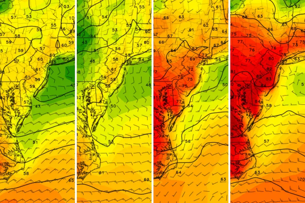
A chilly start will yield a cool day. But a wind shift on Friday will kickstart warm air advection — that is the technical term for a warmup. By the weekend, thermometers will push above-normal. And by early next week, it will be almost 20 degrees warmer than it is on Thursday.
Meanwhile, there are minimal rain chances in the forecast here. Stretches of dry air and dry weather are typical of November. Our next storm system and chance of widespread rain won't be until the Tuesday-Wednesday time frame.
Thursday
As of this writing (6 a.m.), temperatures across New Jersey range from 23 degrees (Sussex County) to 39 degrees (Long Beach Island and Atlantic City). A deep stretch of 20s extends from North Jersey into the Pine Barrens.
So it is a cold start, which will have you reaching for a sweater, coat, and/or car heater early on Thursday.
And we will have a cool finish to the day, with high temperatures only reaching about 45 to 50 degrees. That is 10+ degrees below normal for this time of year.
No wind, visibility, rain, or snow problems. It will be sunny and dry. Just unseasonably cold.
Thursday night will be cold too, although probably not as cold as the previous night. Our forecast puts low temperatures in the lower to mid 30s. A frost or freeze is possible.
Friday
Let the warmup begin! The wind direction will shift from northwesterly to southwesterly on Friday, carrying warmer air into New Jersey. Although temperatures will still be held below seasonal normals, it will be a better, more comfortable day than Thursday.
Look for highs in the mid 50s on Friday. Once again, sunshine will dominate the sky, aside from some clouds creeping in around late afternoon.
Friday night will not be a freeze for most of the state. (Outside of the usual cold spots in the northwest hills and Pine Barrens.) Lows will dip to around 40.
Saturday
All things considered, the first weekend of November looks pretty good. Temperatures will continue climbing. And rain chances stay low.
We do lose the brilliant blue sky on Saturday. But I'll call it partly sunny, averaging about 50 percent cloud cover. There is a slight chance of a shower clipping northern New Jersey late-day.
High temperatures on Saturday will push past 60 degrees. Maybe as warm as 65 in South Jersey. Not bad for early November.
Sunday
Sunday's temperatures tick upward a couple more degrees, landing in the mid 60s by the afternoon. It looks like Sunday's sky will be cloudier, but still allowing for peeks of sun. Again, I can not rule out a quick shower or sprinkle at some point, but most of NJ should stay completely dry.
The Extended Forecast
The relative warmth continues through Monday and part of Tuesday (Election Day), as temperatures come close to 70 degrees. We won't be breaking any records, but those qualify as mild November days.
Just like Sunday, I suspect we'll have more clouds than sun on Monday and Tuesday.
In addition, a cold front will slide into New Jersey on Tuesday. At the moment, this frontal boundary looks moisture-starved, so I am going with a dry forecast. However, a few raindrops (or even snowflakes, if the timing is right) can't be ruled out completely. Tuesday night turns breeze and cooler.
So by Wednesday, high temps will scale back to the 50s again. Some model runs have painted a minor storm system passing over New Jersey, with some rain and snow chances. (Yes, the "S" word!) But six days out, I'm really not worried about those details just yet.
LOOK: Most common jobs 150 years ago in New Jersey
Gallery Credit: Stacker
LOOK: Which movies were filmed in New Jersey?
Gallery Credit: Stacker
More From WPG Talk Radio 95.5 FM
