
Two ‘4-letter words’ in NJ’s Forecast Thursday: Cold, Snow
The Bottom Line
Not only will it be the grand finale of this week's cold snap. Not only will Thursday likely be New Jersey's coldest day of the week. But we have a good chance of snow showers too. Which may put a dusting on the ground across the western edge of the state Thursday morning.
Warmer days are ahead though. I have had to temper the start of our warmup on Friday. But by Saturday, we should see comfortable widespread 50s across the Garden State. A nice way to start the weekend.
But the end of the weekend will turn quite nasty, as a strong cold front drives in Sunday. While you might salvage dry weather for Sunday morning, heavy rain and gusty winds will be big concerns by Sunday night.
Thursday
It's cold. By the numbers, similar to a "late January, dead of winter" kind of weather day. 20s and 30s Thursday morning. Highs will only reach about 40 degrees Thursday afternoon.
A weak disturbance diving out of the Great Lakes will clip New Jersey around mid to late Thursday morning. (Let's say 8 a.m. to Noon.) Given the chill in the air, a wave of snow showers and flurries is looking likely.
There are several limiting factors in play. First, our air is still very dry — so any showers will probably fizzle to flurries before reaching the eastern half of NJ. Second, the ground is relatively warm — 5-centimeter soil temperatures are hovering around 40 degrees. So for the most part, snow will melt as it hits the ground.
Having said that, there is a chance the ground whitens up in spots, with a dusting or coating possible. Again, especially to the west. I do not think snowflakes and slippery road conditions will interfere with travel though. It's just "conversational snow".
Thursday afternoon will bring breaks of sun amongst the clouds. That forecast high temperature around 40 is almost 10 degrees below normal for early December.
Thursday night will turn mainly clear, and temps will be seasonably chilly. Look for lows around the freezing mark, in the lower 30s.
Friday
Let the warmup begin! After three days of unseasonably cold weather, we will enjoy a three-day warm up through the upcoming weekend.
Friday should feel like a decent December day. High temperatures will end up around 50 degrees, close to normal for this time of year. It won't be warm, but definitely comfortable. (Especially in direct sun, especially when wearing a jacket.)
Expect sunshine, with passing clouds, and dry weather from start to finish.
Saturday
Saturday gets even warmer, with highs pushing into the mid 50s. Forecast models show a mostly cloudy day. That won't be a dealbreaker though — it should still be relatively pleasant.
Sunday
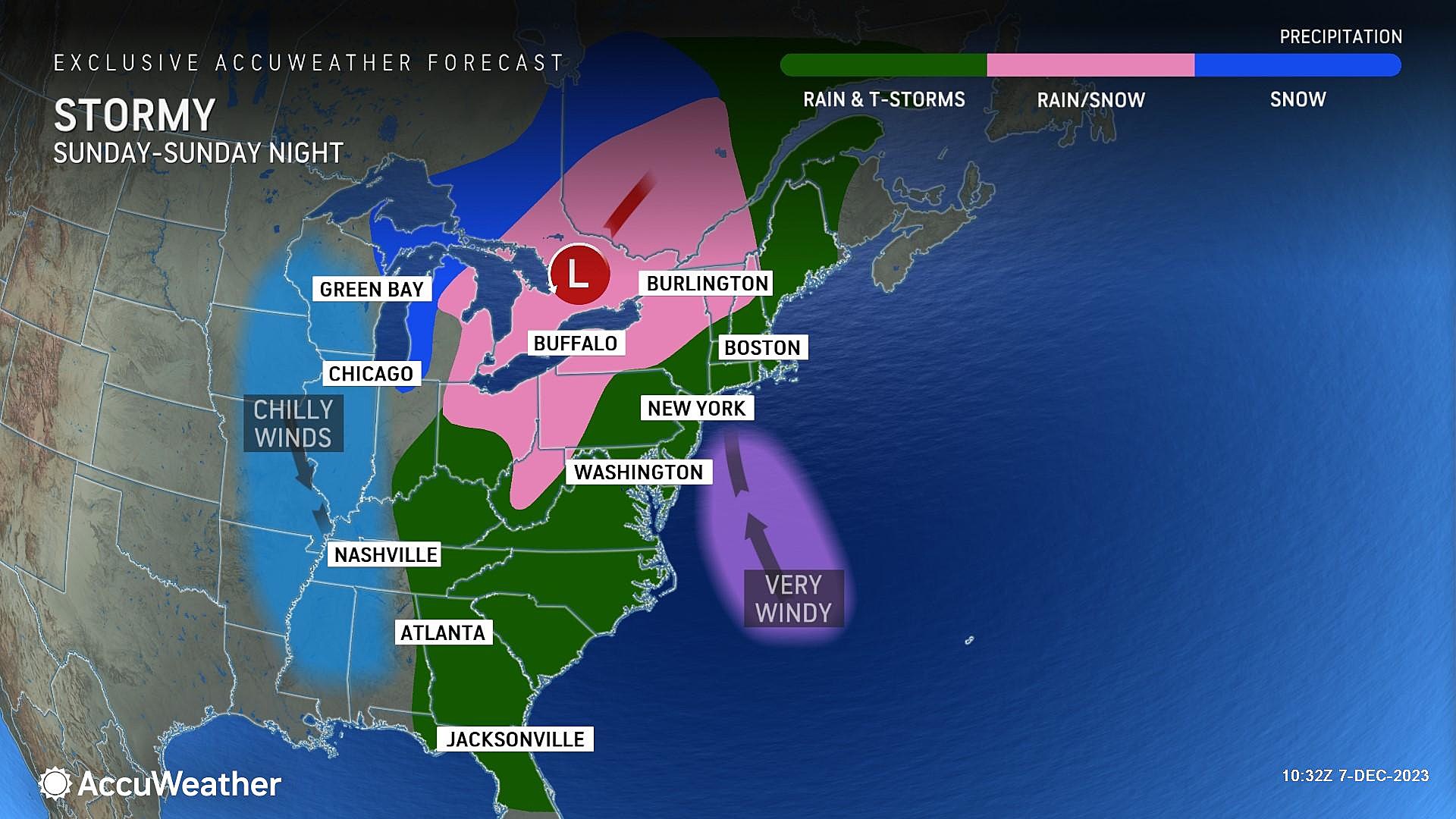
For several days now, we have noted the possibility of stormy, nasty, wet and windy weather on Sunday, as a strong cold front arrives from the west. And that is absolutely still the case — we are even starting to nail down the storm timeline.
Let me start with the good news. Sunday morning might be OK. A strong southerly wind will kick up eventually, helping to fuel the grand finale of our warmup. Highs across most of the state will push to 60 degrees. (Some guidance goes as high as mid 60s in South Jersey — that's pretty darn warm!)
Showers may start to creep in by lunchtime. And our weather will go downhill even more Sunday afternoon, as steady rain kicks in.
The threat for heavy downpours and gusty (potentially damaging) winds will kick in Sunday evening. Our weather will get pretty rough for a few hours Sunday night.
Overnight rain storms are not as big a deal as daytime ones, since the number of New Jerseyans out and about on the roads is much lower. However, given the forecast of 1 to 2+ inches of rain, there is a potential for flash flooding. Especially since leaf piles are still blocking storm drains and gutters, which could allow those "big puddles" to form quickly.
Again, with those warm temperatures, this one is almost exclusively wet and not wintry. (There is a slight chance of snowflakes mixing in around NW NJ early Monday morning — but don't count on it.)
Monday & Beyond
Rain should wrap up right around daybreak Monday. And temperatures will drop sharply in the early morning hours, as a new cooler, drier air mass moves in.
By mid-morning Monday, it will be sunny. And breezy. And chilly again. Temperatures will settle around the lower-mid 40s Monday afternoon. (I can't call that the "high" for the day, since it may still be ~60 degrees just after Midnight.)
Tuesday and Wednesday will be quiet, cool weather days with sunshine and highs in the 40s. Our next chance of a substantial storm system is modeled to stay away until late next weekend.
Let it snow: 12 things to know about winter forecasting in NJ
Gallery Credit: Dan Zarrow
Glossary of NJ winter weather words and phrases
Gallery Credit: Dan Zarrow
More From WPG Talk Radio 95.5 FM


