
NJ Weather: Scattered Storms Tuesday, Heat Wave Ahead
The Bottom Line
So far, July has been a pretty wet month across New Jersey. All sectors of the state have picked up at least 4 or 5 inches of rainfall, with some pockets seeing much more. For most, it is the wettest month since at least last October.
We do have more rain on the way through the final week of the month. Specifically on Tuesday, and again over the weekend.
Meanwhile, we have been devoid of extreme heat. So far in 2023, we have seen 14 90-degree days at the Newark Airport weather station. 7 at Trenton, 6 at New Brunswick, 3 at ACY in Egg Harbor Township, and 0 at the Jersey Shore. For most, that is below normal for this point of the season.
We will add to those tallies in the coming days, as New Jersey faces its hottest stretch of 2023 so far.
The combination of heat and humidity will put us in the "danger zone". But the impending heat wave will be brief — no more than four days.

Tuesday
If you can dodge the drops of rain and bolts of lightning, Tuesday continues our trend of nice summer days. It will be the last day of this stretch with near-normal temperatures and manageable humidity.
We are starting the day with a bit of haze and lots of sun. Morning temperatures are mainly in the 60s, an effect of not-too-high humidity.
High temperatures Tuesday will push into the mid 80s. That is similar to Monday, and close to the long-term normals for late July. Morning sun will give way to afternoon clouds.
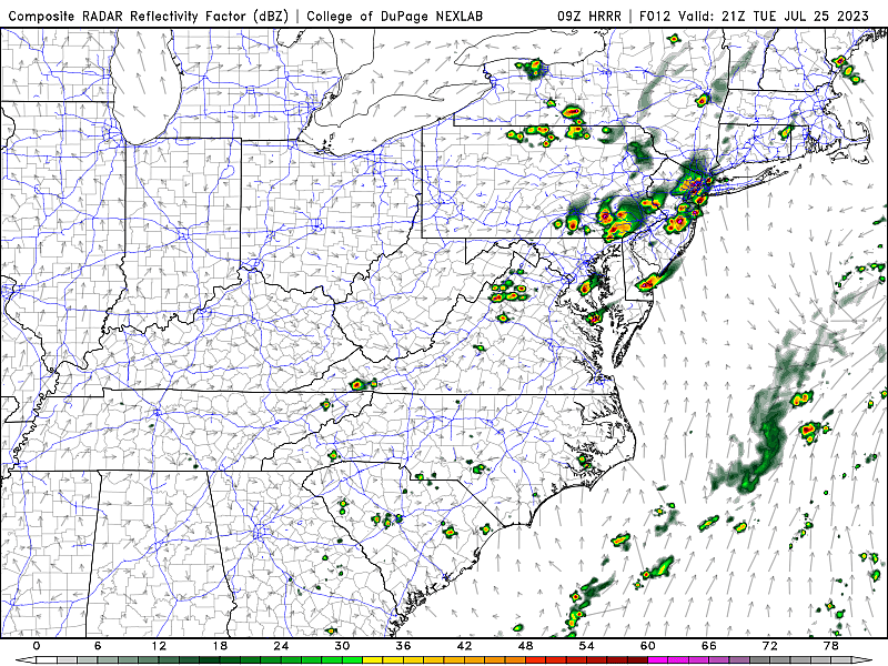
Also this afternoon, we will have to watch the sky for some scattered thunderstorm activity. The window for potential storms will be about 1 p.m. to 8 p.m. (early afternoon through sunset).
This is yet another situation where not everyone in NJ will see a storm. But if you do, a quick downpour is a good bet. Gusty winds, small hail, and lightning are possible too.
Skies clear into Tuesday night, with low temperatures descending to around 70 degrees by Wednesday morning.
Wednesday
Warmer. And more humid, especially at night. But the daytime hours look good —not in the stifling heat wave just yet.
Expect mostly sunny skies and high temperatures in the upper 80s to around 90 degrees. Wednesday should be storm-free.
Wednesday night will be much muggier than the past few nights, as humidity starts to surge in our atmosphere. Lows will only dip into the 70s.
Thursday & Friday
Ready or not, here it comes. Heat and humidity are going to be quite uncomfortable for both Thursday and Friday. (The forecast is so similar, I have decided to just lump them together.)
High temperatures will reach the lower to mid 90s across most of New Jersey both days. The Shore may benefit from a sea breeze, keeping temperatures slightly cooler. But 90 at mainly beaches is still a possibility.
As dew points spike into the 70s, humidity will be in the "tropical" category. The combination of heat and humidity produces the heat index, often called the "feels like" or "apparent" temperature. But practically, the heat index is an important measure of human health effects of hot weather. When it exceeds 100 degrees, we call it potentially dangerous heat.
I did the math. Heat index on Thursday and Friday is forecast to reach 105.
There will be a prominent breeze out of the southwest. But it will be a hot "blast furnace" breeze, offering little to no relief.
A popup thunderstorm is possible either day. But lacking any significant lift or steering current, and capped by a hot air mass, widespread storm activity is highly unlikely.
The Weekend & Beyond
The worst heat waves are the ones that roll on and on for days and weeks. This one will not fall into that category, as temperatures should only pop to 90+ degrees for four days, at the most. Relief comes this weekend, although the details and the timing is still uncertain.
At some point, a cold front will push from northwest to southeast across the state, ending our heat wave. At the moment, I favor a midday-afternoon arrival. That means 1.) We'll probably still hit 90+ degrees on Saturday, 2.) A round of daytime thunderstorms is possible, and 3.) More comfortable weather resumes Saturday night.
If all goes well, Sunday could be another "best of the entire summer" kind of weather day. But again, it is all about the timeline. We will keep you posted as this stormy, sweaty, summery forecast continues to evolve.
See inside: Burlington County Farm Fair
Gallery Credit: Kyle Clark
CHECK OUT: All the free beaches in New Jersey
More From WPG Talk Radio 95.5 FM


