Rain returns to NJ this weekend: Saturday afternoon to Sunday morning
The Bottom Line
I am so happy we are squeezing out a dry weather day to close out this active workweek of weather. Friday will give a chance for puddles to evaporate, waterways to recede, and New Jerseyans to soak in a little bit of sunshine.
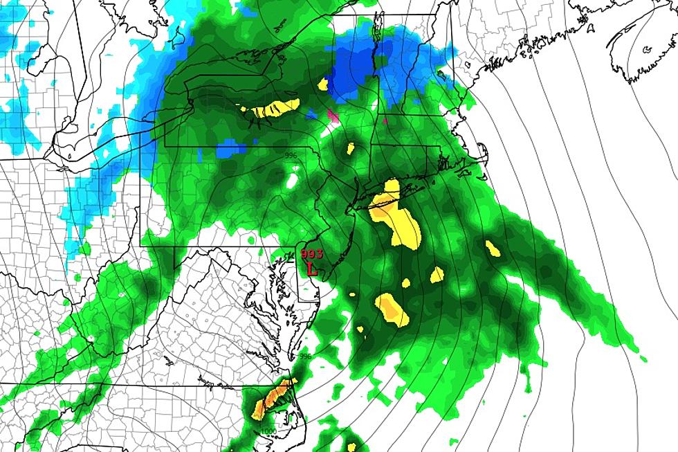
There is one and only one storm system left in this sequence, set to soak New Jersey again over the weekend. The forecast has not changed — Saturday afternoon to early Sunday morning turns wet, with up to an inch-plus of total rainfall expected. Nothing wintry, just wet. Rumbles of thunder and some elevated wind gusts are possible.
Once the rain wraps up Sunday, it will turn windy for a few days. The payoff will be an extended stretch of dry, quiet weather. Probably leading to some 60s and 70s around the Garden State by late next week.

Friday
Good news from start to finish. We are back on the cool side Friday morning, with many temperatures in the 30s. (Even below freezing in Sussex and Warren counties.) High temperatures will push into the mid 50s for most of the state Friday afternoon.
A prominent southeasterly sea breeze will kick in Friday, keeping the Shore a bit cooler, closer to the 50-degree mark.
I am calling Friday partly sunny overall, but really we'll start with mainly clear skies and end with increasing clouds.
Of course, the best part of all? We are staying completely dry. Leave the umbrella at home.
Friday night stays dry and quiet too. Skies become cloudy, as low temperatures once again bottom out in the upper 30s or so.
Saturday
Saturday will not be a perfect weather day. But you will find stretches of dry weather for outdoor activities.
That is especially true in the morning. It will be pretty "blah" and feeling raw, with cloudy skies, a few sprinkles, and high temperatures limited to the upper 40s.
The main event — the arrival of our next storm system — is coming Saturday afternoon. I still think 3 p.m. is a reasonable start time for raindrops, although latest model guidance shows much more variety. (Anywhere from a 1 p.m. to 9 p.m. start time, realistically.)
Wet weather will continue into Saturday evening and the overnight hours. And late night will be the brunt of the storm, with bands of heavy rain likely. There could even be some embedded thunderstorms, generating lightning and possibly some gusty winds. Things will get pretty nasty for a few hours Saturday night.
Sunday
By daybreak Sunday, rain will be done. Skies will clear quickly through the rest of the morning. So it will look like a nice day. But Sunday turns windy and cooler too, with potential gusts to 40 mph.
Temperatures will drop from the lower 50s Sunday morning into the 40s through the afternoon. Not an arctic blast. But a noticeable transition, especially given the brisk wind.
Monday
Monday stays windy and blustery, although we should be treated to a gloriously sunny day. I could still see some wind gusts in the neighborhood of 40 mph. (March is generally a windy month, as warm air masses constantly clash with cool air masses.)
A freeze is a possibility Monday morning, as low temperatures drop to around 30. High temperatures on Monday should settle around 50 degrees. Both of those numbers are right on the normals for this time of year.
Tuesday & Beyond
Once the wind dies down Tuesday, the forecast shows a shift in wind direction from northwesterly to southerly. Oh, a south wind is glorious this time of year. It means we are warming up.
Thermometers may flirt with 60 degrees on Tuesday, again with mostly sunny skies. And then into the 60s we go for Wednesday and Thursday. Cloud cover will build, and we could see an isolated shower at some point. But that will be a taste of real April-ish warmth.
Some models are even showing widespread 70s by the end of next week. Our next chance of widespread rain won't be until the start of next weekend.
New Jersey's St. Patrick's Day Parades 2024 (by date)
Gallery Credit: Dan Alexander
Dan Zarrow is Chief Meteorologist for Townsquare Media New Jersey. Follow him on Facebook for the latest forecast and realtime weather updates.
2024 Seaside Heights Polar Bear Plunge raises $2.75M
Gallery Credit: Andrew Miller/For New Jersey 101.5
More From WPG Talk Radio 95.5 FM