
Monday NJ Weather: Warm and Juicy Atmosphere, Nasty Thunderstorms
The Bottom Line
The coastal gloom of last week is over. And now it's time for some summerlike weather.
You will definitely notice some humidity in the air Monday. Not stifling, just there. That humidity will be a big factor in Monday's summery feel. And in the stormy weather set to arrive later on.
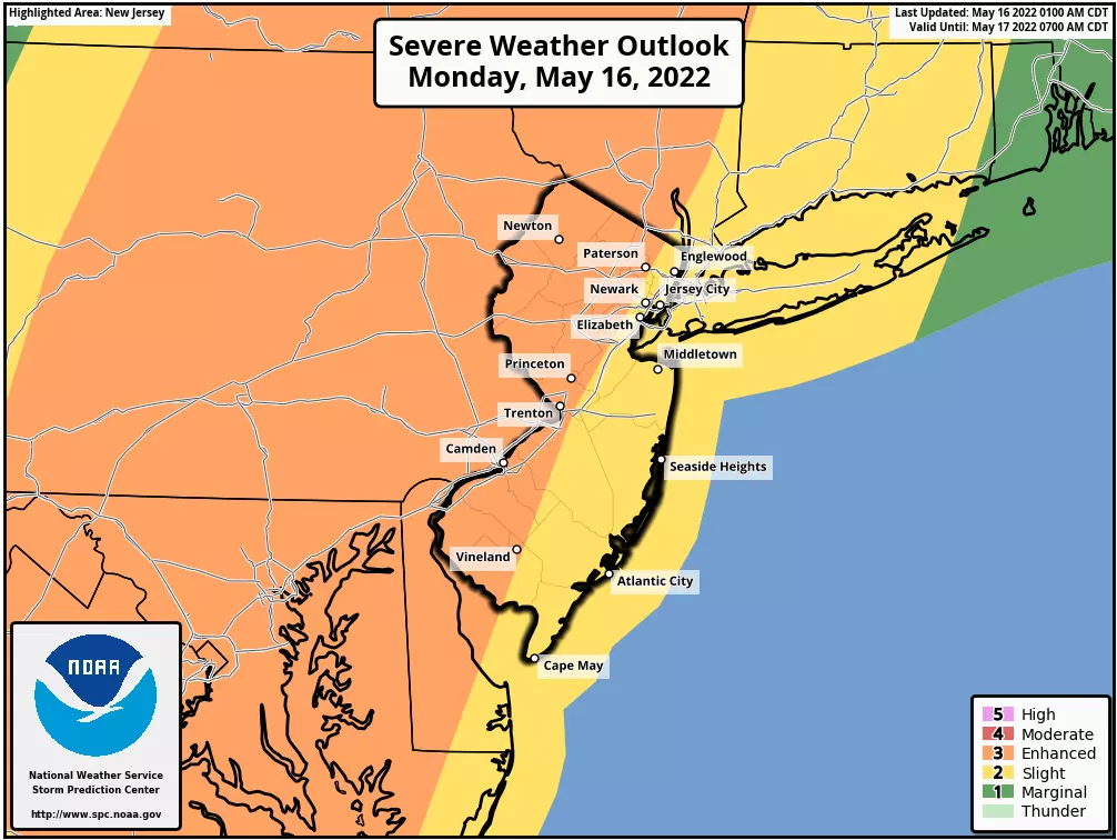
Monday is going to turn into a severe weather day. Period, full stop. Widespread strong to severe thunderstorms are likely in the 2 p.m. to 8 p.m. time frame. Gusty winds, heavy rain, and wicked lightning are our biggest concerns. Hail and a tornado are possible, too.
So you need to stay "weather aware" Monday afternoon and evening, as those storms roll in. Pay extra attention to changing weather conditions, and please take it seriously.

We'll lose the humidity on Tuesday, but pick up some wind.
Two more batches of rain are coming this week. One from Wednesday night to Thursday morning, and another batch of showers on Friday.
Then we get cooking, as heat builds next weekend. 90s are likely for much of New Jersey by Saturday afternoon.
Monday: Timeline
Let's talk about storm timing first. Then we'll look closer at the expected impacts.
We're starting Monday with some patchy fog and temperatures in the 60s. It feels like a pleasant June morning.
Skies will be partly sunny through Monday morning and midday. High temps will reach about 75 to 80 degrees. Pretty close to where we ended up Sunday. Warm and humid enough to make you sweat, and possibly go reaching for the shorts and skirts.
A spot shower or weak thunderstorm is possible at any time Monday. (Models specifically pinpoint 10 a.m. to 1 p.m. as the best chance for some meandering raindrops.)
Our main event will begin around 2 p.m. Monday afternoon, give or take. Fueled by the heat (instability) and humidity (moisture) in the air, and sparked by an approaching cold front (lift), a line of strong to severe thunderstorms will likely impact the entire state.
The most widespread and strongest storm activity will probably be between about 4 and 6 p.m. Ugh, perfectly coinciding with the evening rush.
Storms should largely pulse down and exit the state around 8 or 9 p.m. Monday evening. And then skies will clear, while humidity levels and temperatures drop overnight.
Monday: Impacts
This is not one of those "conditional" weather situations, where if storms form they might be strong or severe. Nope. There will be thunderstorms, and they will pack a punch.
Not to get too technical, but these storms will have plenty of instability (energy) to work with. CAPE (Convective Available Potential Energy) of 2,000 to 3,000 J/kg is pretty high here in New Jersey. Dew points will also rise close to 70 degrees, adding plenty of moisture to fuel soaking storms.
In terms of geography, it's pretty clear the strongest storms of the day will be the initial burst along the western edge of the state. Storms should fizzle at least a little bit as they approach the cooler, more stable air along the Jersey Shore.
Overall, the biggest concern Monday will be wind. Storms should squall out and become linear rather quickly, given the advance of the cold front to the west. Gusts of 40+ mph are likely, and 60+ mph are possible. That's strongest enough to blow down trees and power lines, and make driving conditions especially nasty. Therefore, it's the number one reason you don't want to be out and about during the strongest storms Monday afternoon/evening.
Concern number two is heavy rain, which could lead to ponding and flooding of low-lying and poor-drainage areas. Keep in mind, the strongest storms will coincide with most New Jerseyans' evening commute. Driving through blinding rain is no fun at all.
Dangerous cloud-to-ground lightning is also a concern. By definition, every thunderstorm contains lightning. And the atmosphere should be charged up enough to give a noisy show before, during, and after the storms.
Hail is possible. And I can't rule out a tornado or two. They're not at the top of the list, but certainly potential impacts to keep in mind.
I suspect SPC/NWS will issue a watch around midday Monday. Remember, that's just a formal heads up that the atmospheric ingredients are coming together for dangerous weather. Warnings are issued when storms are imminent, and that's when you want to take action, change plans, and take shelter in a sturdy building.
Tuesday
The arrival of a new air mass will bring a flip to brighter, drier, nicer weather Tuesday.
50s in the morning, mid 70s in the afternoon. So it's not going to be that much cooler — temperatures should still hover at or above seasonal normals. It will feel way less humid and more comfortable too, as dew points dial back to the 50s.
We'll enjoy lots of sunshine throughout Tuesday. The northwest wind may kick up for a few hours, with gusts over 25 mph. Given the warmth, sunshine, and dry air, I think the breeze will feel refreshing rather than a nuisance.
Wednesday
The coolest day of the week.
NW NJ and the Pine Barrens could touch 40s Wednesday morning, as the core of dry air passes overhead. Highs on Wednesday will come close to 70 degrees, with skies progressing from sun to clouds.
Our next storm system will arrive sometime late Wednesday, driving in some rain showers. I do not see anything crazy developing here — no severe weather, just some rain, mainly at night.
Thursday
Some model guidance shows rain lingering past 8 a.m. Thursday morning. But the rest of the day should be good. Skies will slowly clear to partial sunshine.
And temperatures will start to warm up again, thanks to a return of southerly winds. Highs on Thursday should reach the seasonable mid 70s. The Shore will likely be a few degrees cooler than inland areas.
Friday & Beyond
The warmup continues. From warm to very warm to downright hot.
On Friday, we could see a few showers creep in. Best chance currently looks to be throughout the southern half of NJ. High temperatures will push into the lower 80s, despite the raindrops and scattered to broken clouds.
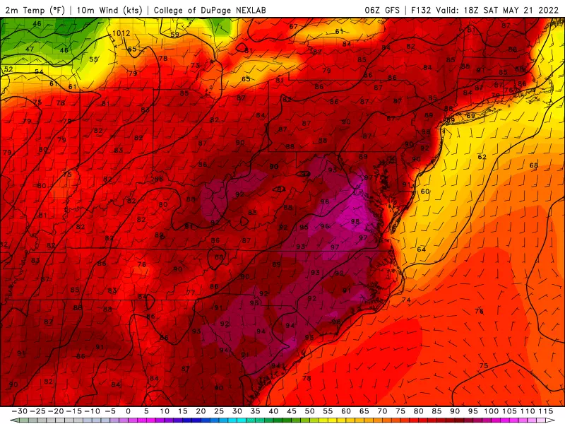
Saturday will be the hottest day of the week. In fact the hottest day of the season so far, as temperatures soaring into the lower 90s across most of the state. Time to fire up the air conditioner and/or open up the pool for the season, perhaps? And make sure you dress for the hot weather and stay hydrated, of course.
A cold front will put an end to the heat sometime Sunday. And it will carry a round of potentially strong thunderstorms too. But the timing of that frontal passage is in question. The Euro model favors Sunday morning, leading to a wet start and cooler finish to the day. Meanwhile, the GFS paints later storms and therefore hotter temperatures overall on Sunday. We'll see how that plays out — just know things will likely turn stormy at some point on Sunday.
Final Thoughts
As with any potentially dangerous weather situation, our entire team is on warm standby to help you stay "weather aware". Live coverage will continue on-air and online all day, to help you stay ahead of any nasty storms. Thanks, as always, for following along. And please be smart and stay safe out there.
BEEP BEEP BEEP: These are the 13 types of Wireless Emergency Alerts auto-pushed to your phone
Counting down New Jersey's top 15 weather stories of 2021
More From WPG Talk Radio 95.5 FM


