
NJ weather: Humidity and temps drop, one rain chance this week
The Bottom Line
On balance, the holiday weekend weather was very good. Saturday and Sunday were bright and dry and warm. Of course, Memorial Day Monday was plagued by thunderstorms and downpours — but at least we avoided any severe weather reports.
Heading back to work and school on this Tuesday — yes, it's Tuesday — we have a transition underway. Humidity scales back Tuesday morning as a drier air mass arrives, leading to much more comfortable conditions. Temperatures will also be on a slow decline, with more seasonable and then cooler-than-normal numbers expected as the week goes on.
There is only one substantial rain chance coming up, late Wednesday to Thursday. But with heat and humidity zapped from our atmosphere, it will be fairly uneventful — the severe weather threat is low.
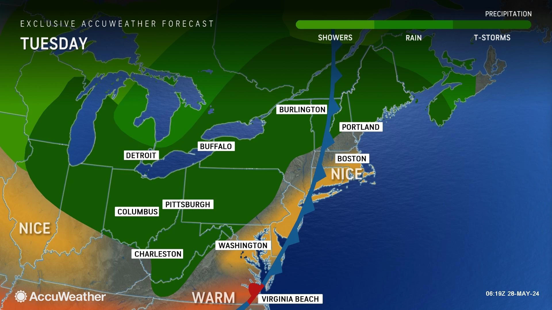
Tuesday
First of all, it is going to be a very nice day.
It is a somewhat sticky, summerlike start to the day. There are areas of fog that will lift quickly, and temperatures are firmly in the 60s. A drier air mass is starting to leak into the state. And as dew points drop, the air will become much more comfortable by late morning.
High temperatures on Tuesday will be nice and warm, near 80 degrees. This will be the 9th day in a row with 80+ degrees somewhere in New Jersey.
We will enjoy mostly sunny skies and a fresh breeze, westerly up to 20 mph.
If you are aiming for a weekday beach day, the weather will mostly cooperate. But there are a couple of yellow flags in the Jersey Shore Report: 1.) a moderate risk of rip currents, and 2.) that strong land breeze could blow flies toward the beaches.
Tuesday looks almost totally dry. I just can't rule out a shower or thunderstorm clipping NW NJ in the early evening hours, just before sunset.
The rest of Tuesday night will be clear and comfortable. It will be a typical late May night, with low temperatures around the upper 50s.
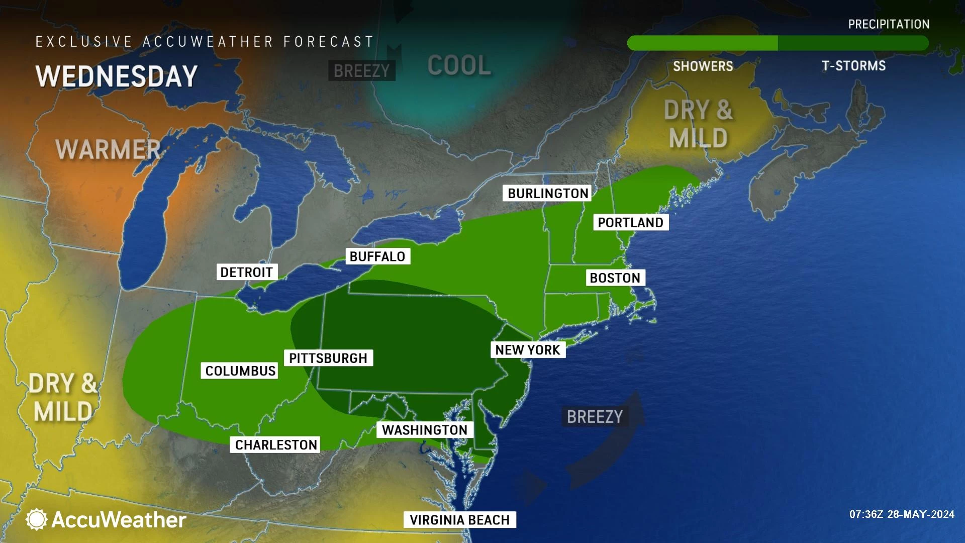
Wednesday
Most of Wednesday will be just fine, especially during the daytime hours.
Sunshine will dominate the sky Wednesday morning, before clouds gently build in Wednesday afternoon. High temperatures will dip a little bit, to the mid-upper 70s.
A round of spotty showers and thunderstorms is likely late-day Wednesday, possibly as early as the afternoon but more likely in the evening hours.
Not everyone will see a storm. And because it will not be "hot and humid," the available energy and moisture is limited for severe thunderstorms to explode.
Still, a few raindrops may get in your way — rainfall may top a quarter-inch in spots.
Thursday
I will keep the shower/storm chance alive for Thursday, although anything that pops up looks isolated and brief.
With clouds and some sun, Thursday's high temperatures will only reach the lower 70s. That is still quite pleasant. But notably a few degrees below normal for late May.
Friday
Friday looks fine. Partly sunny, with highs again in the lower 70s. A quiet finish to May.
The Extended Forecast
Can you believe Saturday is June 1st? The start of climatological summer. And the official start of the Atlantic hurricane season.
The long-range forecast for the weekend looks good. Especially since temperatures will start to warm up again. I'm seeing 75 to 80 on Saturday, followed by lower 80s (away from the coast) on Sunday.
The only potential weekend hiccup is a shortwave driving in a quick patch of rain Sunday morning. We will keep track of the timing, duration, and intensity of that as the week rolls on.
POP QUIZ: Can you guess these NJ landmarks from Google Earth images?
Gallery Credit: Dan Zarrow
NJ Street Fairs are back! See the latest 2024 schedule
Gallery Credit: Mike Brant
More From WPG Talk Radio 95.5 FM


