NJ Weather Turns Nasty: Rain, Wind, Coastal Flooding Timeline
The Bottom Line
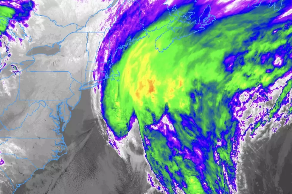
An area of low pressure racing across Virginia and North Carolina will produce an extended period of nasty weather across New Jersey. By the numbers, over the next 48 hours, we'll see about 2 inches of total rainfall, wind gusts kicking up to 40+ mph, 2 to 3 feet of storm surge causing coastal flooding, and miserably cool temperatures running about 20 degrees below normal.
It will certainly be inclement. But will this storm system be dangerous? Eh.
I really don't think this is a "batten down the hatches, all hands on deck" kind of a storm. But it's definitely going to be inclement, if not nasty at times. And there are some impacts to watch for.
Downpours may cause ponding, or big puddles. Gusty winds may bring down branches and cause power outages. Tidal flooding may exceed moderate flood stage, for several high tide cycles in a row. There is a slight chance for some lightning, or even a strong/severe thunderstorm, in South Jersey only.

Let's run through the timeline of this nasty weather. And look deeper at whether we'll see any improvements for Mother's Day Sunday. Or next week, for that matter.
Rain / Flooding
As of this writing (6 a.m. Friday), it's fairly quiet. Radar is picking up on some light showers and patchy drizzle so far.
Friday morning, scattered rain showers will push in from the west.
By Friday afternoon, rain will become steadier and more widespread.
Friday night, starting around 6 p.m., we get soaked. Pockets of heavy rain could lead to ponding or flooding of low-lying or poor drainage areas.
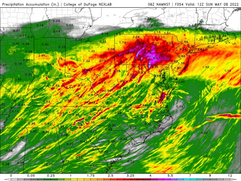
On Saturday, rainfall intensity will dial back a bit. But it's still going to be a wet day, with substantial bands of rain over New Jersey all day long.
While you may find some breaks in the rain, it won't affect the overall feel of the day — it's going to be wet.
Finally, I just want to be crystal clear and perfectly blunt about this forecast. This is not another Ida. This rainstorm is not going to produce multiple-inches-an-hour rainfall. Flash Flood Guidance does suggest that 1-inch-an-hour rainfall would be sufficient for flooding issues in northeastern New Jersey. So that's something to watch during the "brunt" of the storm Friday night through Saturday morning. Street flooding is possible. And rivers, streams, and creeks will run high by the end of the weekend. But again — inclement, not necessarily dangerous.
Wind
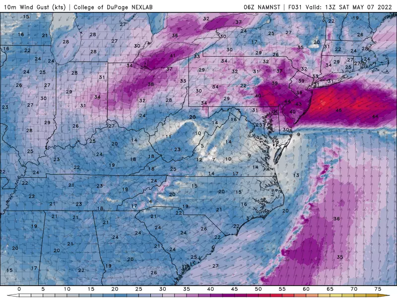
As of this writing Friday morning, winds are calm. And they'll stay that way through the daytime hours.
As of around 6 p.m. Friday evening — coinciding with heavier rain arriving — the wind will start to kick up too. We could see gusts of 30 mph overnight, blowing out of the northeast.
Wind speeds will peak on Saturday, possibly topping 40 mph. Strongest gusts will likely occur around southern and coastal NJ.
Coastal Flooding
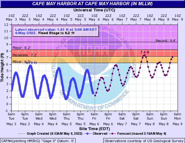
Tidal flooding is probably the most precarious impact of this coastal storm. Especially since it's going to last for several high tide cycles in a row.
Those strong northeast gusts will push a lot of ocean water toward the Jersey Shore. Latest tide guidance shows upwards of 2 to 3 feet of storm surge. That would put water levels right at moderate flood stage, starting with Saturday night's high tide. A Coastal Flood Watch has been issued for the Jersey Shore.
Even though the rain will end and winds will subside a bit on Sunday, the storm system will be lingering off the coast through early next week. That will keep us under a northeasterly flow, keeping bays and other tidal waterways full.
So minor to moderate flooding is likely going to happen for several more high tides on Sunday and Monday, and possibly beyond. The PM tide will be higher than the AM tide.
This degree of coastal flooding may necessitate road closures, and could cause minor property damage in particularly vulnerable areas. Remember to never attempt to drive, walk, or swim through flooded areas.
Temperatures
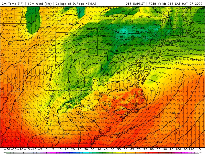
Along with raindrops and wind and clouds will come some unseasonably, uncomfortably cool temperatures.
Friday could touch 60 degrees in spots, before thermometers start slipping backwards in the afternoon.
Friday night will dip to around 50.
And then it will only get cooler through the day on Saturday. We'll basically be stuck in the 40s all day. At least 20 degrees below normal for early May.
Mother's Day Sunday
We will see some improvements just in time for Mother's Day. Most forecast models show steady rain coming to an end by daybreak Sunday morning.
However, as the area of low pressure stalls off the coast, it will continue to spit showers and drizzle our way. The best chance for lingering raindrops on Sunday will be NJ's southern coast.
At the very least, it will remain cloudy, breezy, and cool on Sunday. High temperatures will only improve to the mid 50s in the afternoon.
The Extended Forecast
The attempted arrival of warmer air next week will be tempered by a continuing on-shore wind. It happens every Spring, where a chilly ocean breeze keeps New Jersey unusually dreary and cool. This is a particularly long stretch of such conditions.
However, models do show some glimmers of hope for inland New Jersey next week.
Monday still looks mostly cloudy and breezy. And, surprise surprise, I can't rule out a few showers. High temps will come close to 60. (Again, remember our normal high right now is close to 70 degrees.)
Tuesday and Wednesday will turn partly (if not mostly) sunny. Inland high temperatures will push through the 60s. But it will be quite a bit cooler near the oceanfront.
70s will be possible late next week. But again, not at the Shore.
Best spots to pick your own NJ strawberries 2021
An enlightening tour of Washington, NJ ... all six of them!
More From WPG Talk Radio 95.5 FM