
NJ Weather: When Will the Intense Heat and Humidity Break?
The Bottom Line
The heat rolls on. Friday will be day #3 of NJ's first heat wave of the season. And it could be the most scorchingly uncomfortable day of the stretch, with hot temperatures, high temperature, and blazing sun.
But as I have said over and over this week, it is important to maintain perspective here. Heat is serious business. It can be dangerous and even deadly, if you do not take care of yourself. However, we are not necessarily breaking records. (Although Friday's highs will be close in spots.) And there is an end in sight to the intense heat and humidity.
Our heat wave grand finale will be this weekend. While Saturday will be steamy and somewhat stormy, Sunday will bring sweet relief to the Garden State.

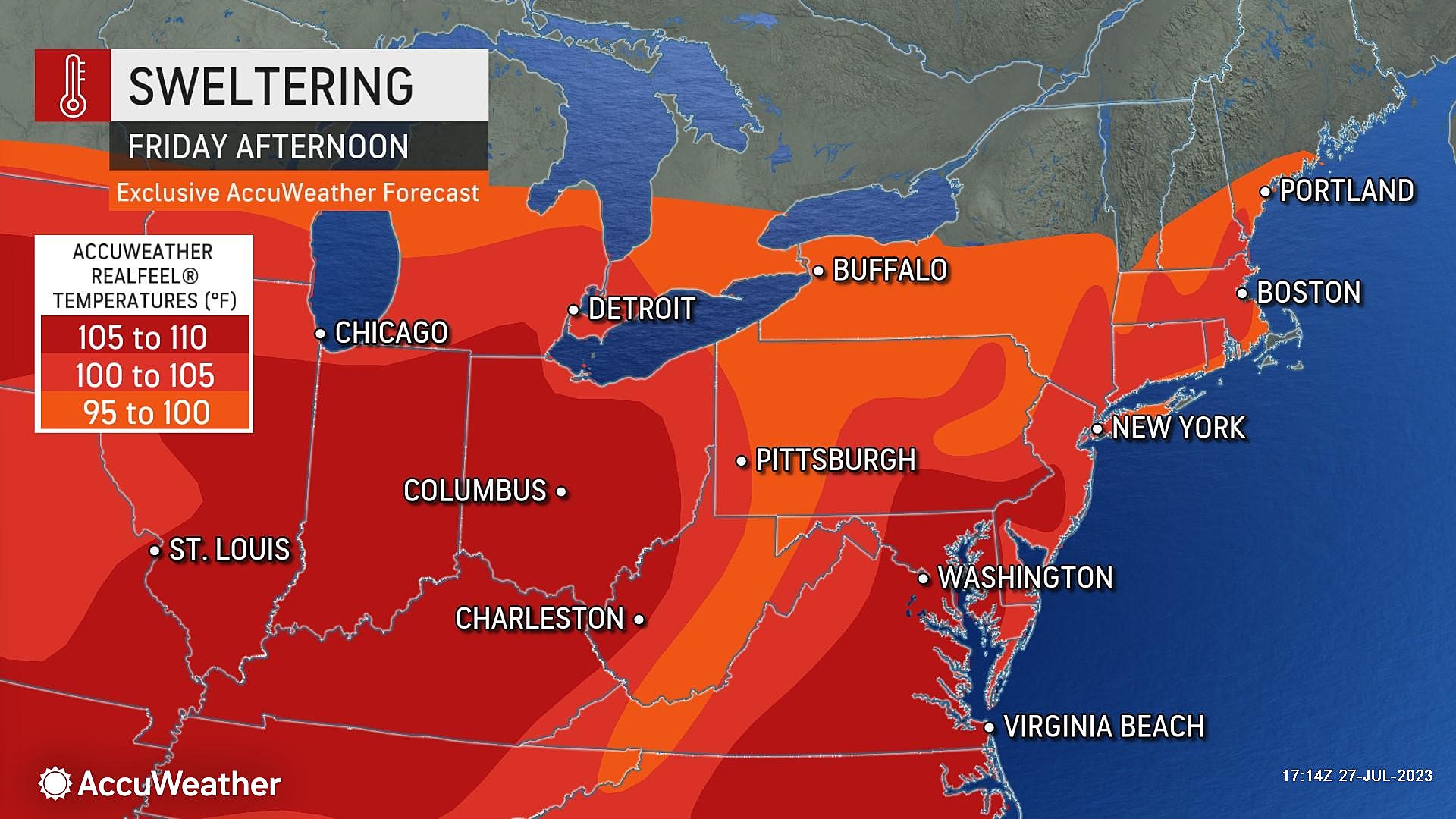
Friday: Ferocious Heat & Humidity
By the numbers, Friday will be similar to Thursday. Definitely hot, with high temperatures in the lower to mid 90s for most. Definitely humid, with dew points firmly in the 70s. Definitely sunny, with some haze and occasional clouds along the way.
Heat warnings and advisories are posted for almost all of New Jersey. Urban centers will swelter the worst.
It is worth mentioning that the southwest "blast furnace" breeze will be lighter on Friday than Thursday. I do not think that will significantly impact your comfort level in this soupy air mass. But it might allow for more of a sea breeze along the Jersey Shore, keeping more beaches in the 80s this time around.
The chance of a popup thunderstorm at some point Friday is low, but not zero. Latest model guidance resoundingly shows bupkis. However, with a juicy atmosphere, it would not be impossible for an isolated storm cell to form. Worth a mention, but do not go canceling your plans.
Once the sun goes down Friday evening, it will stay pretty warm again. Overnight lows will only dip into the 70s. Really not that cool, at all.
Saturday: One More Steamy, Stormy Day
The final weekend of July features a big transition. Cold front. Thunderstorms. Relief.
Saturday will be another steamy day. Abundant cloud cover will probably keep temperatures a few degrees cooler than Thursday and Friday. But humidity will still be high. Look for highs in the lower 90s. 80s along the immediate coast and in northwestern New Jersey.
You may have to dodge a few showers or thunderstorms through the midday and afternoon hours. Not constant, and the day will not be a washout.
The biggest chance for stormy weather will be between about 4 p.m. and 10 p.m. Saturday, as an approaching cold front sparks a line of strong thunderstorms. Heavy rain, gusty winds, and dangerous cloud-to-ground lightning are possible. Those storms will be moving quickly, so they will not last long. But things could get nasty for an hour or two, on either side of dinnertime.
Behind the storms and behind the front will come a cooler, drier air mass. That will start to filter into New Jersey Saturday night, especially after Midnight. Some low temperatures will probably drop into the 60s by Sunday morning.
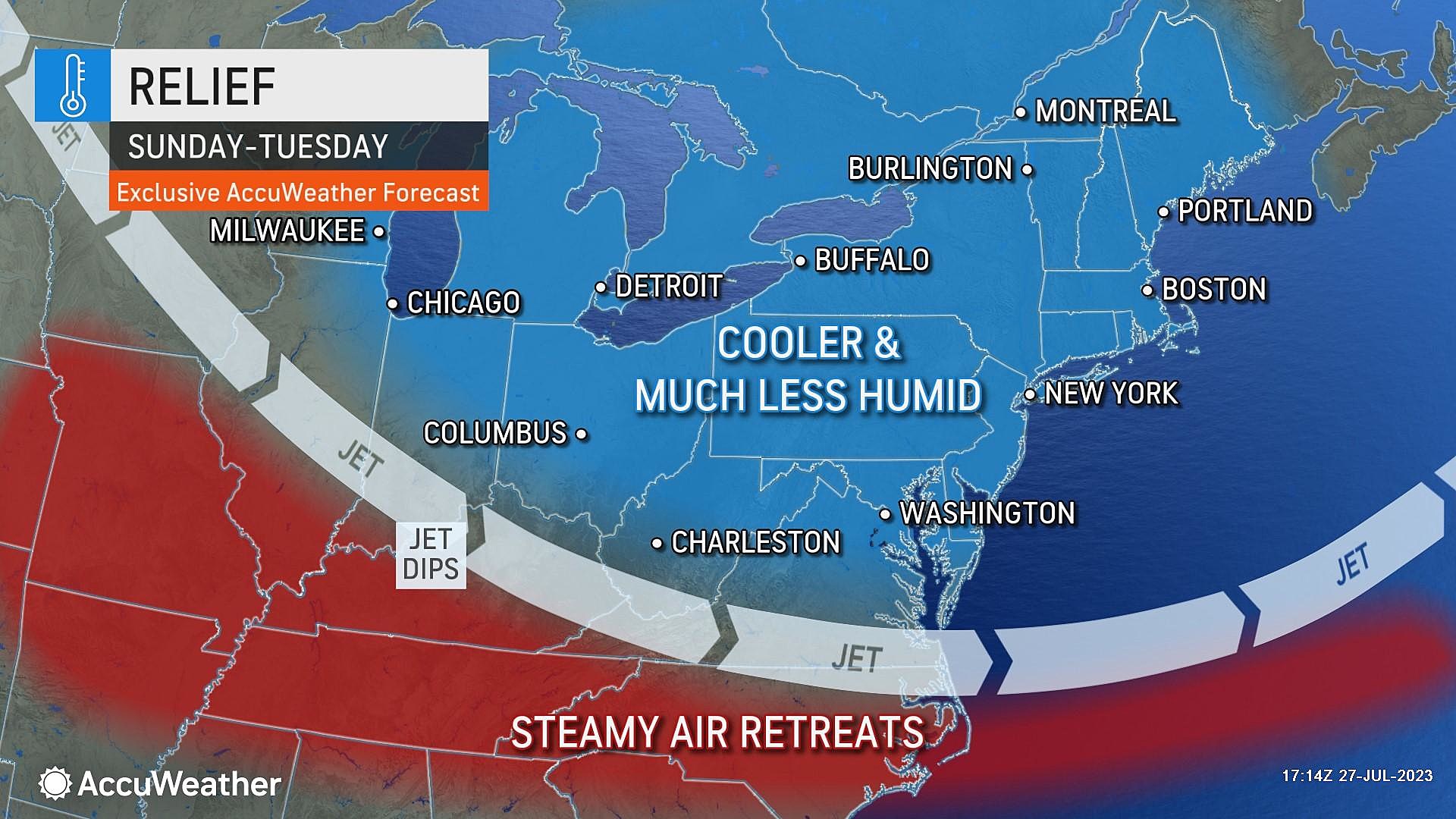
Sunday: Sweet Relief
While a shower is still possible through mid-morning Sunday, we will otherwise enjoy beautiful weather for the second half of the weekend.
No more 90s — highs will come down to the lower 90s on Sunday. Plus, dew points will descend through the 60s, possibly ending up in the 50s. That is drier, more comfortable air that will make the air feel quite refreshing.
Monday & Beyond: More Beautiful Weather
The low humidity and pleasant weather looks to continue through the first half of next week. Monday, Tuesday, and Wednesday are trending dry and mostly sunny, with high temperatures in the lower 80s. That is slightly below normal for this time of year. But a nice change of pace from our recent heat wave.
Warmer, more unsettled weather looks to return around Thursday or Friday of next week. But I do not see any return of extreme heat or humidity for a while.
The tropics are also still relatively quiet.
7 ways to cool your home without AC in the NJ heat
Gallery Credit: Alex Lam, Clint Patterson, Jason Anderson, Jonathan Chng, Jorge Flores, Matt Brown, Omar Sotillo Franco all via unsplash.com
LOOK: The most expensive weather and climate disasters in recent decades
Gallery Credit: KATELYN LEBOFF
More From WPG Talk Radio 95.5 FM


