Snow then rain: 7 things to know about NJ’s wintry, wet weekend
1.) The Bottom Line
This weekend's weather will not be nice. From snow to ice to rain. From cold to warm to really cold. Plus wind.
By the numbers, up to 4 inches of snow, a quarter-inch of ice, and 2+ inches of rain are expected around New Jersey between Saturday and Sunday. What a mess.
Then it turns really cold and windy next week, potentially setting us up for a snow storm by late week. But ignore the hype — big snow is far from a guarantee at this point.

2.) Before the Storm
Friday is the one fairly quiet weather day in this forecast. You will "love" the abundant sunshine throughout the day. The cold wind, however? Not so much.

We are starting Friday morning with temperatures around 30 degrees, back on the cold side. High temperatures will only reach the mid 30s or so Friday afternoon. A brisk wind will gust to 20 mph through the first half of the day, likely calming after lunchtime. And again, it is nice to see the sun again.
Clouds will start to increase Friday night, as thermometers dip quite cold. Lows are forecast to reach the lower 20s on average across the Garden State.
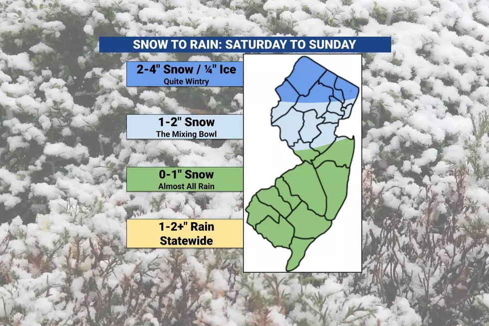
3.) Weekend Storm Forecast: Soggy South Jersey
Let's start with the good news. If there is one corner of New Jersey that desperately needs a good soaking, it is South Jersey. Not only to wash away all the remnant snow and slush from our last storm. But also to provide some relief to the "Extreme Drought" status that has been in place for months.
Saturday morning will be fine. There is a good chance that as precipitation arrives Saturday afternoon, it will fall as snow and/or wintry mix for the entire state.
Then, as warmer air surges from the south, any wintry mix will transition to plain rain by around dinnertime (6 or 7 p.m.) Before that happens, there could be a coating on the ground and slippery spots on the roads — but accumulations here will be limited.
Periods of rain will continue into Sunday, becoming quite heavy at times. It will wrap up by mid to late afternoon. Total rainfall may exceed 2 inches in spots.

Meanwhile, high temperatures on Sunday will flirt with 60 degrees.
One thing to watch: The warm rain will cause all snow and slush to melt on Sunday. That will result in some extra large puddles.
4.) Weekend Storm Forecast: The Mixing Bowl
The timeline here is similar to southern parts of the state. Initial snow will arrive Saturday afternoon.
But then wintry mix will linger for a while, likely not changing to plain rain until later Saturday evening. Say around 9 or 10 p.m.
That will be enough time for an inch or two of snow to accumulate. The farther north you are, the more snow will accumulate. More than enough to cause some travel slowdowns. But overall not a big deal — especially since any snow will quickly wash away as the rain picks up.

Periods of rain will continue into Sunday, becoming quite heavy at times. It will wrap up by mid to late afternoon. Total rainfall of 1 to 2 inches is expected. High temperatures should soar well into the 50s, especially the farther south you are.
5.) Weekend Storm Forecast: Wintry North
Conditions will be a bit more wintry and impactful along and north of Interstate 80.
Once again, we will be watching the western sky for first snowflakes around Saturday afternoon for the northern edge of New Jersey. But then snow will continue to fall and accumulate until at least Midnight. There could be sleet mixed in too.
I have bumped up our North Jersey accumulation forecast to 2 to 4 inches. Some models and forecasters are going as high as 6 inches — I think that is a stretch, given the eventual mixing and transition to plain rain.
The upper end of that range, 4 inches, would qualify as a "moderate" snow event. Definitely some tricky travel conditions.
The National Weather Service has issued a Winter Weather Advisory for eight counties in North Jersey, cautioning of treacherous travel conditions:
—Noon to 10 p.m. Saturday... Hunterdon and Somerset counties.
—Noon Saturday to 1 a.m. Sunday... Bergen, eastern Essex, eastern Passaic, and Warren counties.
—Noon Saturday to 4 a.m. Sunday... Morris and Sussex counties.
Furthermore, I am very concerned about a period of freezing rain developing in between the snow and plain rain. That would be late Saturday night. And could create a glaze of ice — up to a quarter-inch — making things extra slippery.

By daybreak Sunday, wintry concerns should fade and we face a wet day with periods of rain. Total rainfall to the north may exceed an inch. High temperatures will not be as warm as just to the south, getting stuck around 40 degrees.
6.) After the Storm
After rain wraps up Sunday afternoon, another arctic blast arrives just in time for President's Day.
That cooldown looks to be a very windy transition, with gusts on Monday possibly exceeding 40 mph. High temperatures will only reach the mid 30s.
Tuesday will be the coldest day. Expect teens in the morning, with potentially dangerous wind chills near zero. And then highs will barely reach the freezing mark, in the lower 30s.
7.) Nor'easter Next Week?
Social media is buzzing about a storm threat around Wednesday-Thursday next week. A potential nor'easter snow bomb.
As I have mentioned for the past few days, forecast models do show a storm system in New Jersey's vicinity in that time frame. In fact, I will say this is the best heavy snow storm setup I have seen for New Jersey in years.

However, this potential winter storm is still 5 or 6 days away. Hang on a sec.
Forecasting a major storm like this is like baking a cake. All the ingredients are there. But will they come together in the right proportions and bake at just the right temperature? Or will they fall apart, and nobody gets to eat delicious cake?
Both 0 and 2+ feet of snow are possibilities here. But we have to be patient and wait to see how things play out.
After we see what Mother Nature is "cooking up" this weekend, we should start to get a better handle on next week's potential storm. If there are alarm bells to be rung and details to add, we will probably start to do that late Sunday or early Monday.
Let it snow: 12 things to know about winter forecasting in NJ
Gallery Credit: Dan Zarrow
Dan Zarrow is Chief Meteorologist for Townsquare Media New Jersey. Follow him on Facebook for the latest forecast and realtime weather updates.
Final flakes: When does snow season end in NJ?
Gallery Credit: Dan Zarrow
More From WPG Talk Radio 95.5 FM


