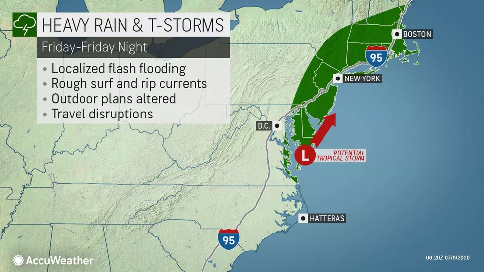
Tropical Rainstorm Forecast for NJ: 2+ Inches of Rain, 40+ MPH Gusts
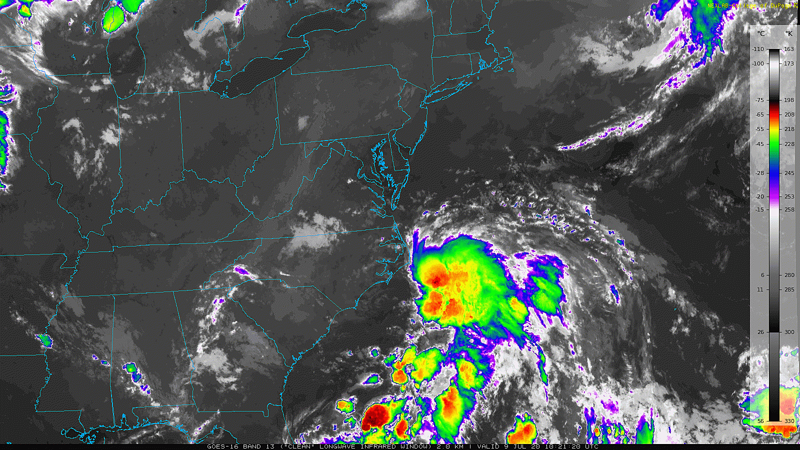
As of this writing, we are less than 24 hours away from some nasty weather here in New Jersey. An area of low pressure is spinning off the coast of North Carolina on this Thursday morning, and will arrive here in New Jersey late Thursday night. It still hasn't become organized nor strong enough to be deemed a tropical depression or tropical storm — although that may still happen. I am putting together this extra special weather blog post to detail the timeline and potential impacts of this tropical rainstorm.
Right off the bat, let me make three important statements about this significant storm system:
1.) Beware the "hype" — the forecast is not a "slam dunk". Guidance consensus shows a hit of heavy rain and marginal wind gusts over New Jersey. However, there are several forecast models that now keep the center of the storm system up to 100 miles east of the Jersey Shore. That would limit the heavy rainfall potential (especially in western NJ), although it would raise the surge and surf threats. I like the way models are trending downward in generally. However, there's reason to be very cautious here, given the severity of the worst case scenario. Because of the uncertainty, you'll see I have opted to lay out a couple of scenarios in the Storm Impacts section below.

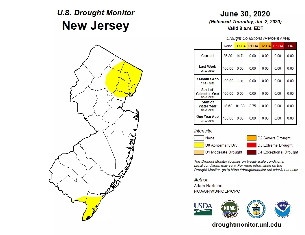
2.) Yes, we need the rain. Parts of the state have been teetering on the edge of drought conditions, given a rainfall deficit over the last 30 to 60 days. (That has been shaved away by our recent heavy thunderstorms.) However, this may be too much, too fast. The worst-case scenario of 4 inches of rain? That is almost on the level of a 5-year storm (20% recurrence). Pretty significant. And almost guaranteed to cause serious flooding.
3.) Do you need to batten down the hatches and/or drastically change your plans for Friday? Probably not. The storm's impacts will be far from "catastrophic". But you still need to be aware and alert. It is shaping up to be a nasty weather day. Heavy rain may lead to flash and river flooding. Gusty winds may cause driving difficulties, downed trees, and power outages. Coastal flooding may lead to water issues and road closures along the Jersey Shore's most vulnerable tidal waterways.
Detailed Timeline
—Thursday daytime... No weather problems. Hot and humid, with an elevated risk of rip currents.
—Thursday 4 p.m. to 10 p.m... Increasing clouds, from south to north.
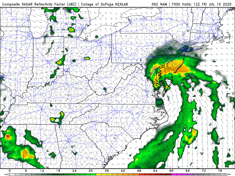
—Thursday 10 p.m. to Friday 6 a.m... Initially light rain bubbles up into South Jersey, spreading north and becoming heavier overnight.
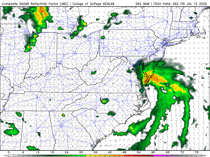
—Friday 6 a.m. to 1 p.m... Pretty nasty, as the peak of the storm begins for New Jersey. Likely raining throughout the state at this point. Heavy rain bands will lead to flooding, visibility, and traction issues. Winds will kick up after sunrise Friday too.
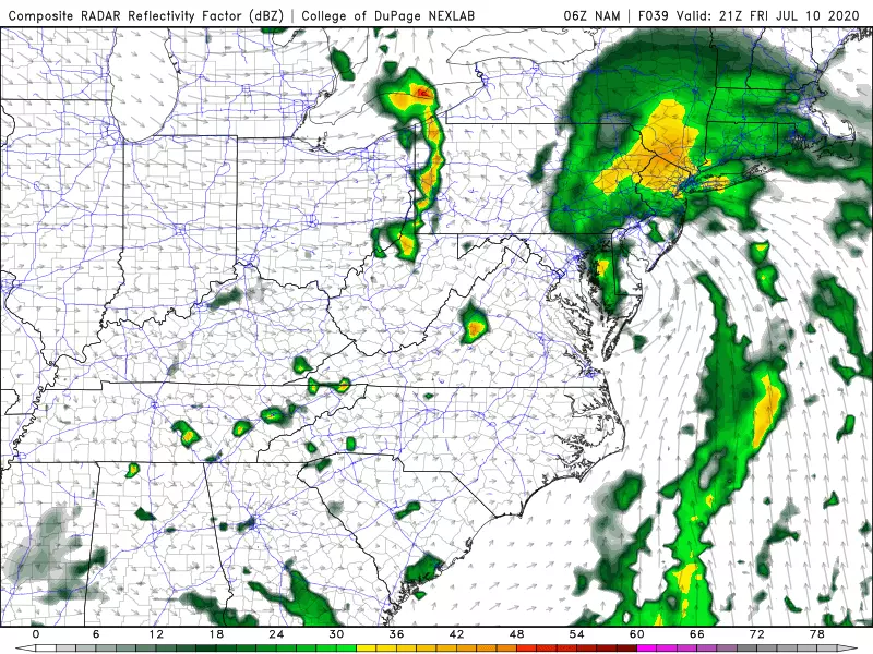
—Friday Noon to 5 p.m... If the center of the storm makes landfall over New Jersey, it will happen around midday around Cape May County. After that point, we'll start to see sky improvements as drier air takes over southern then central NJ. Rain tapers off, but gusty winds will continue. It will remain mostly cloudy and very humid.
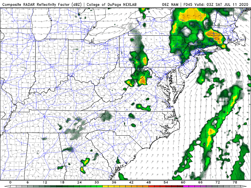
—Friday 5 p.m. to Midnight... Rain still lingering from central to northern NJ. Wind dies down overnight, with partial clearing. Still steamy.
Storm Impacts
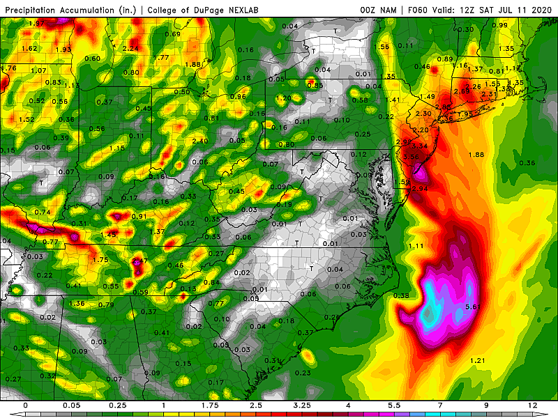
—Rain... Easily the most impactful part of this storm system. But also the element with the most uncertainty, given the variety of storm tracks still on the table. Worst case scenario rainfall totals would be between 2 and 4 inches statewide. Within heavy rain bands, flash and river flooding could impede travel and become downright dangerous in spots. Meanwhile, the best case scenario (eastern track) actually drops little to no rainfall along the Delaware River in western New Jersey, with an inch or two farther east, along the Jersey Shore.
—Wind... No matter where the storm tracks, we're going to feel some wind starting Friday morning. Most likely scenario would be 30+ mph gusts across most of the state, with 40+ mph gusts at the beaches. I have to include the "plus" on those numbers, because a perfect storm setup would push those top wind speeds about 10 to 15 mph higher. Driving difficulties, downed branches and trees, and power outages are possible.

—Surf... Already rough. A moderate risk of rip currents posted for Thursday, and that will absolutely bump to high for Friday. Having said that, I'm only seeing wave heights climb to about 4 to 5 feet, so we should miss out on significant beach erosion.
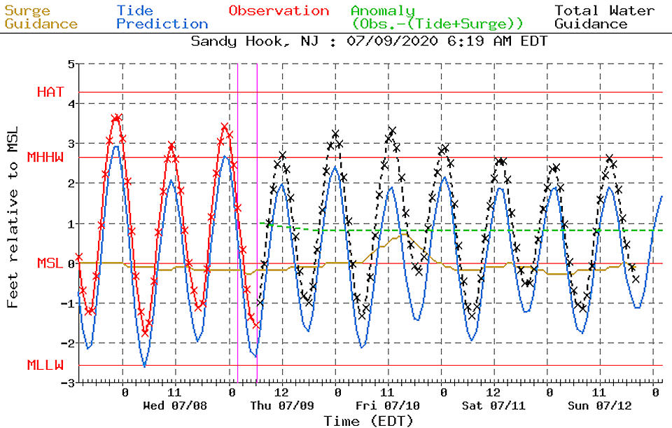
—Surge... Storm surge estimates have unsurprisingly crept upward in the past day. About a half-foot to a foot of extra water will push against the Jersey Shore. That's enough to cause minor category flooding at high tide. If we get longer-duration or higher-speed easterly winds, that estimate may rise a bit more. But I don't think the coastal flooding will surpass advisory-level. Road closures may be needed near particularly vulnerable tidal waterways.
—Severe Weather... Still a minor concern, especially if the center of the low tracks over New Jersey. The Storm Prediction Center puts NJ under a 5% wind risk and 2% tornado risk for Friday. Pretty low. Sounds right to me.

—Humidity... Yes. Tropical. Even though high temperatures will only reach about 80 degrees Friday, it is going to be steamy. And you are going to be sweaty.
Our Coverage
We'll get one more primary round of model guidance before Thursday afternoon, before the storm ramps up Thursday night. If there are significant changes, I will update my digital weather blog and on-air forecasts accordingly.
And then our weather, traffic, news, digital, and programming teams will be all-hands-on-deck with the play-by-play of the nasty weather. (I'll probably be in the weather center from 3 a.m. to 3 p.m. Friday.)
Be smart, be safe!

Flooding in Ocean City on July 6th
More From WPG Talk Radio 95.5 FM


