
Weekend Storm System Looks Like a Glancing Blow for NJ
I love all the weather-folk declaring that winter is over! Just in case you're wondering, normal season-to-date snowfall for Newark is 12.8" and Atlantic City is 7.8". Normal snowfall for the entire season totals 25.4" at Newark and 14.2" at Atlantic City. So the snow season is, on average, only half-over! Still plenty of time to see some wintry weather.
And what do you know, there could be some snowflakes (and raindrops) around the Garden State on Saturday. We'll get back to that in a moment. (Feel free to scroll down if you can't wait.)
Wednesday morning is starting off very similarly to the past few mornings, with scattered clouds and temperatures in the mid to upper 30s. (Once again, a bit warmer than I expected.) As high pressure passes overhead, Wednesday should become a bright, sunny day across the Garden State. Dry air and dry weather will contribute to a fair late January day. High temperatures will top out between about 40 and 45 degrees — slightly above normal for this time of year.
As long as skies remain mostly clear Wednesday night, it's going to get quite cold. I expect most low temperatures to bottom out in the mid 20s. But the coldest spots in the state — NW NJ and the Pine Barrens — could dip into the teens.
While Thursday should start mostly clear, thick clouds will make for a somewhat grey day overall. High temperatures will be even cooler, limited to the upper 30s. An isolated shower or sprinkle can't be ruled out. (Although, notably, I opted to leave those raindrops out of my "on-the-air" forecast for now.)
We will bounce back nicely on Friday, with highs back in the mid 40s amidst breaks of sunshine. We'll enjoy one more quiet and dry day to end the workweek.
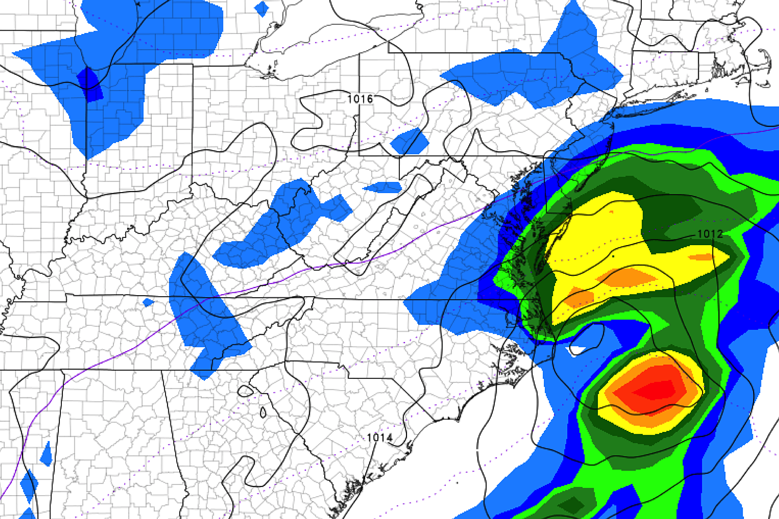
And then things get potentially interesting to start the weekend. An area of low pressure will eject from the North Carolina coast late Friday. And if this system comes close enough to New Jersey, we could face some wet and/or wintry impacts here.
(Note: I've been calling this a coastal storm system. But I'm not comfortable saying it's a nor'easter. That's a very hype-ish term. And I'm not sure it will be close enough to the NE US to drive through that degree of wind and weather impacts.)
For now, let me throw out five quick statements, laying out what we know now.
1.) Confidence... With about 72 hours to go, we are starting to zero-in on this forecast. However, it's still a close call. And models continue to waffle between hit/miss and rain/snow. Literally a few miles difference along the forecast track could shift our forecast dramatically. So it's still a precarious situation.
2.) Bottom Line... A "middle of the road" glancing-blow forecast seems most likely at this point. Not a "direct hit" massive snowstorm. But not "nothing" for New Jersey either.
3.) Timing... It would be a pretty quick hit of precipitation, also minimizing potential weather impacts. First drops/flakes would be early Saturday morning. Models show things should wrap up by Saturday mid-afternoon. Skies clear substantially on Sunday.
4.) Impacts/Geography... One big ingredient missing here is a sufficient pool of cold air. That means we're probably looking at mainly rain along the coast, with temperatures generally in the 40s. Maybe some snow developing farther inland, if the storm tracks far enough north and west. But as it stands now, accumulations would be limited to an inch or two at the most.
5.) Coastal Flooding... This could be a problem, depending on how much the storm system strengthens over the Atlantic and how much it churns up the ocean. Tidal guidance is only reliable about 48 to 72 hours out, so we'll get some resolution on this part of the forecast soon.
So, no reason to ring the alarm bells yet. As we get even closer to first drops/flakes, we'll be able to get even more specific about timing, impacts, and confidence.
Our next next storm system is modeled to arrive in the Tuesday-Wednesday time frame. But I won't even attempt to guess temperatures and precipitation types there until Saturday's storm is gone.

More From WPG Talk Radio 95.5 FM


