Blizzard Warning: Heavy Snow Will Accumulate Quickly Overnight in NJ
It's already snowing hard across most of New Jersey, and driving conditions will continue to deteriorate dramatically through Saturday.
Sooooo... have you looked outside lately? It's snowing!
Our grand nor'easter made its grand entrance Friday evening, and quickly started dumping snow over the Garden State. The intensity of the storm will slowly but steadily increase through Saturday morning. This is a big, strong, and downright impressive winter storm that will have a lot of significant impacts across New Jersey over the next 24 to 36 hours.
At this point, the hard part of my job of forecasting this storm is pretty much done. In fact, you might think it's time to kick back, relax, and wait see if my snow forecast verifies. NO WAY! I'm snowed in and camped out at the radio station for the duration of this potential blizzard, to bring you the latest "nowcasting" updates on-air and online.
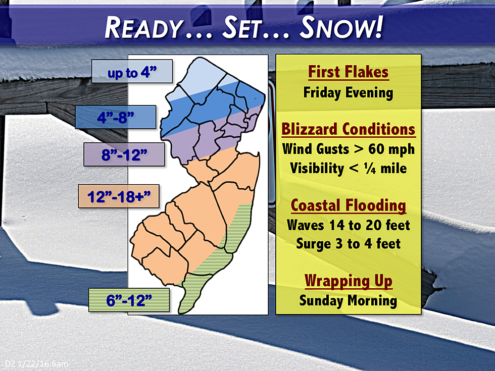
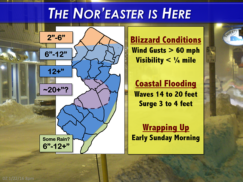
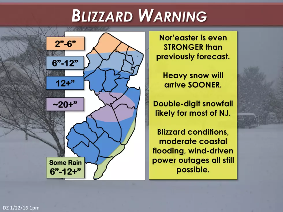
Here's our latest snow accumulation forecast map:
Snow
Yes, a pocket of 20-inch snow totals is expected in central and southern New Jersey. Incredible. But even more astounding will be the large spread of double-digit snow totals, from at least Interstate 78 down to the southern tip of the state. Far North Jersey (particularly Sussex Co.) will be right on the fringe of this snowstorm, and somewhere there will be a big dropoff in snow totals over a very short distance. I still anticipate some mixing with rain along the south coast on Saturday, as temperatures climb to about 40 degrees - I'm still not quick sure about the impact that will have on ultimate snow totals.
Timing
Here's a general timeline for the nastiest part of the storm. This reflects when I expect the snow to accumulate the fastest and for travel to be nearly impossible:
--South Jersey: 7 p.m. Friday - 11 a.m. Saturday
--Central Jersey: 11 p.m. Friday - 5 p.m. Saturday
--North Jersey: 3 a.m. Friday - 10 p.m. Saturday
If you're not at home (or wherever you're hunkering down) now, you should try to get there very soon.
Warnings
The National Weather Service has issued the following winter weather warnings for New Jersey:
A Blizzard Warning has been issued through Sunday morning for the following counties: Atlantic, Burlington, Camden, Cumberland, Gloucester, Hunterdon, Essex, Hudson, Mercer, Middlesex, Monmouth, Ocean, Salem, Somerset, and Union.
A Winter Storm Warning has been issued for Bergen, Cape May, Morris, Passaic, and Warren.
A Winter Weather Advisory calls for lower snow totals for Sussex County.
A Coastal Flood Warning and High Wind Warning are out along the Jersey Shore.
Wind
Sustained winds are expected to climb to the 25 to 35 mph range overnight. Gusts to 40+ mph are expected for inland New Jersey, with regular gusts of 60+ mph along the coast. This will, of course, reduce visibility dramatically and potential cause "true blizzard" conditions. Power outages are possible as well.
Coastal Impacts
That fierce northeast wind will also carry a lot of ocean water and slam it into the coast. Ocean waves of 14 to 20 feet will persist all-day Saturday, likely causing significant beach erosion.
In addition, storm surge of 3 to 4 feet is anticipated, causing Moderate to Major flooding at the times of high tide. The flooding is expected to be worst along the southern part of the coast (Atlantic and Cape May counties).
When Does It End?
Overnight through much of Saturday will remain nasty and wintry, but we should start to see some improvements by Saturday night. I expect most (if not all) of the snow to have tapered off to showers by daybreak on Sunday. Clearing skies and lighter winds will be noticeable by midday on Sunday.
More From WPG Talk Radio 95.5 FM


![Watch the Winter Storm in South Jersey [LIVE CAM]](http://townsquare.media/site/396/files/2016/01/RS9278_177079658-scr.jpg?w=980&q=75)