Brrr! Grab the Winter Coat, New Jersey
Forecast Narrative
For the first time in 2020, an extended outbreak of arctic air has begun here in New Jersey. Temperatures are downright frigid on this Friday morning, in the 20s across most of the state. A continuing brisk wind is keeping the wind chill ("feels like" or "apparent" temperature) in the teens.
We'll likely remain stuck below-freezing all day Friday. And Friday night through Saturday morning will be cold too. Therefore, as our next storm system arrives from the west around midday Saturday, it will likely bring snow at onset to all but the immediate coast.
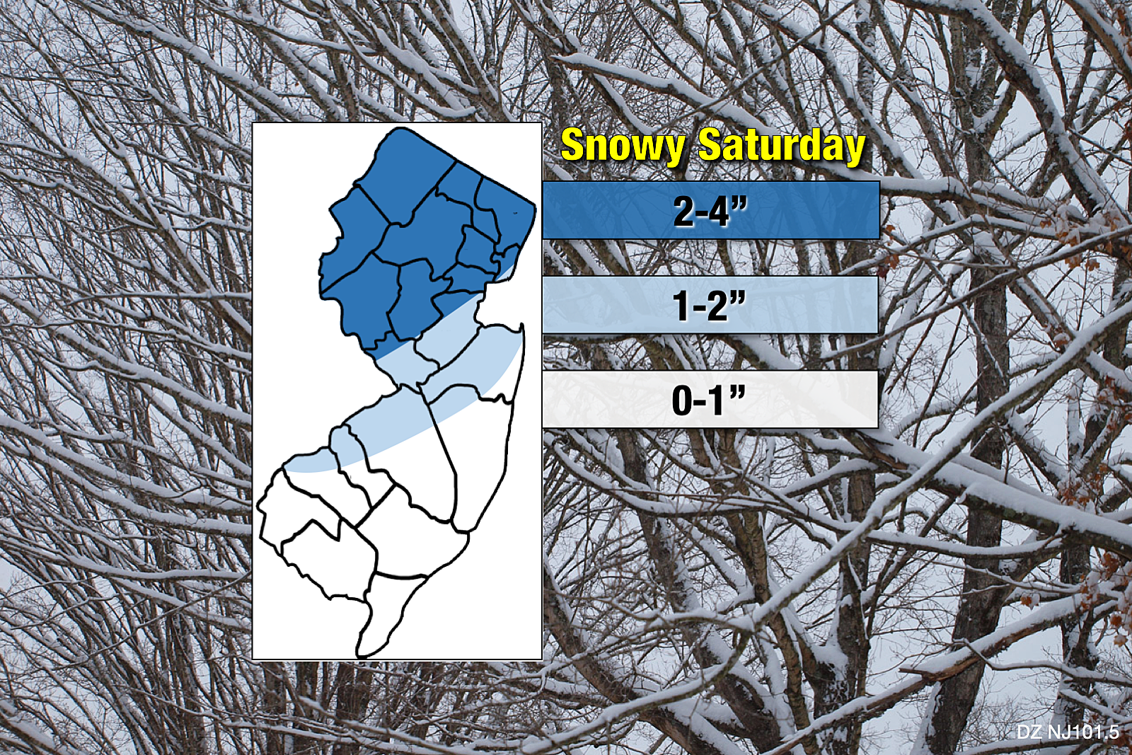
The steadiest, heaviest precipitation in New Jersey will likely fall from Saturday mid afternoon through early evening. Visibility and traction may be poor during this time. Upwards of 4 inches of snow is expected to fall and accumulate in northern New Jersey.
Eventually, warmer air bubbling up from the south-southwest will force a transition from snow to sleet to rain. (Note: In far northern New Jersey, it is possible that precipitation ends due to dry air, before a full transition from wintry to wet.) The storm exits late Saturday evening, with residual showers (mainly rain) possible through early Sunday morning.
I have described this storm system as compact and fast-moving. That piece of the puzzle, combined with the rising temperatures, means we're facing a quick hit of wintry weather. There will be a brief window of slippery, sloppy travel conditions — especially in the main snow zone, colder NW NJ. But a major bread and milk storm, snarling traffic and state operations for hours and days? Nope.
Forecast Changes
The consensus for the starting time seems to have generally shifted an hour or two later. Most of New Jersey will probably remain snow-free until about Noon or later on Saturday.
In addition, the latest NAM model runs have skewed slightly colder, nudging its previous (unrealistic) heavy sleet/ice scenario toward a snowier solution. It now comes into better alignment with both the GFS and the still-consistent Euro. Therefore, I feel comfortable realigning my snow totals slightly higher, eyeballing shovelable snow from Mercer-Middlesex counties north. Still keeping maximum snowfall in NJ at 4 inches. And still keeping 0 snow in play for NJ's coastal and southern counties.
Winter Weather Advisory
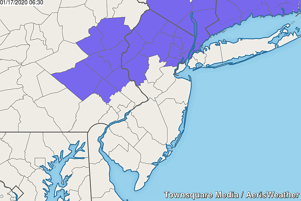
The National Weather Service has already put out a Winter Weather Advisory for 9 counties in northern and western New Jersey. Bergen, Essex, Hudson, Hunterdon, Morris, Passaic, Sussex, Union, and Warren counties fall under an advisory from 10 a.m. Saturday to 1 a.m. Sunday.
I am a little surprised NWS issued this advisory so early. (I expected it to come Friday afternoon.) I'm also a little confused why Somerset County in particular is not covered — their geography is a bit weird to me.
Remember, an advisory serves as a formal heads-up to hazardous travel conditions. It will likely activate certain governmental resources, and reminds all of us to slow down and exercise extra caution and patience when driving.
Forecast Complications
As with every winter storm forecast, I have to play the "what if" game with about 24 hours to go until first flakes. There are a few scenarios I am watching on both ends of this forecast.
—The heaviest snow from this clipper system is expected to be north and west of New Jersey, where colder temperatures will allow for an all-snow setup. Some models and forecasters have suggested snow accumulations as high as 6 inches for northwestern New Jersey. I can not say for sure such over-performance won't happen. My forecast based on my best estimation of snowfall intensity, speed of temperature rise, and overall timing — and I really like where my numbers stand at this time.
—Sporadic model runs have shown 2+ inch snowfall snaking down the length of the Delaware River as far south as Salem County. To have this solution play out would be a struggle, given the forecast temperature trend. But this could turn into a matter of where the heaviest snow bands set up early Saturday afternoon.
—Shore and coast, this ain't your storm. In fact, it's possible that temperatures are in the upper 30s as precipitation arrives. That means you would see cold, uncomfortable rain for the duration. Maybe with some slushy snowflakes mixed in. That's why "zero" is part of the forecast here, on purpose.
Beyond the Storm
Hoping for a warmup next week? Heh, fat chance! Things cool down again on Sunday, and unseasonably cold temperatures will be with us through most of next week.
While there could be a few snow showers along the way, our next substantial storm system is currently forecast to arrive next weekend. As that carries warmer air into New Jersey, we're probably looking at a rain (and/or freezing rain) event. (Stay tuned for a more confident forecast as that gets closer, of course.)
Next Update
Since this is not shaping up to be a "major" winter storm for New Jersey, I do not feel the need to post another full update Friday afternoon. (Unless something changes dramatically, of course.) Watch for some social media extras, and you can always catch the latest forecast on-air.
My next weather blog entry will be posted early Saturday morning — just before the wintry fun begins!
Until then, bundle up and stay warm!

More From WPG Talk Radio 95.5 FM


