Coastal Storm System Will Bring Some Rain, Rough Surf to South Jersey
No need to panic: rainfall totals will stay below an inch, no snow is anticipated, and coastal flooding concerns will be in the minor category.
We're coming off a decent, but cool autumn weekend. Saturday's highs were in the 50s, while Sunday improved to the 60s. As the new week begins, a coastal storm system is sliding up the Atlantic seaboard, which looks to provide New Jersey a decent shot of rain through the first half of the workweek.
Monday is starting off cold, with low temperatures in the 20s and 30s. As the day progresses, clouds will increase (especially after 10 a.m.). Monday afternoon's high temperatures should reach the lower 60s, for the second day in a row.
Our first few sprinkles and showers could bubble up into South Jersey around Monday mid to late afternoon.
The chance for showers will then spread northward Monday night. Lows are expected to drop into the lower to mid 40s for most of the state. I could see a few 30s in North Jersey - possibly cold enough to worry about some wintry mix, BUT I don't think the showers will reach the "cold zone" during the overnight.
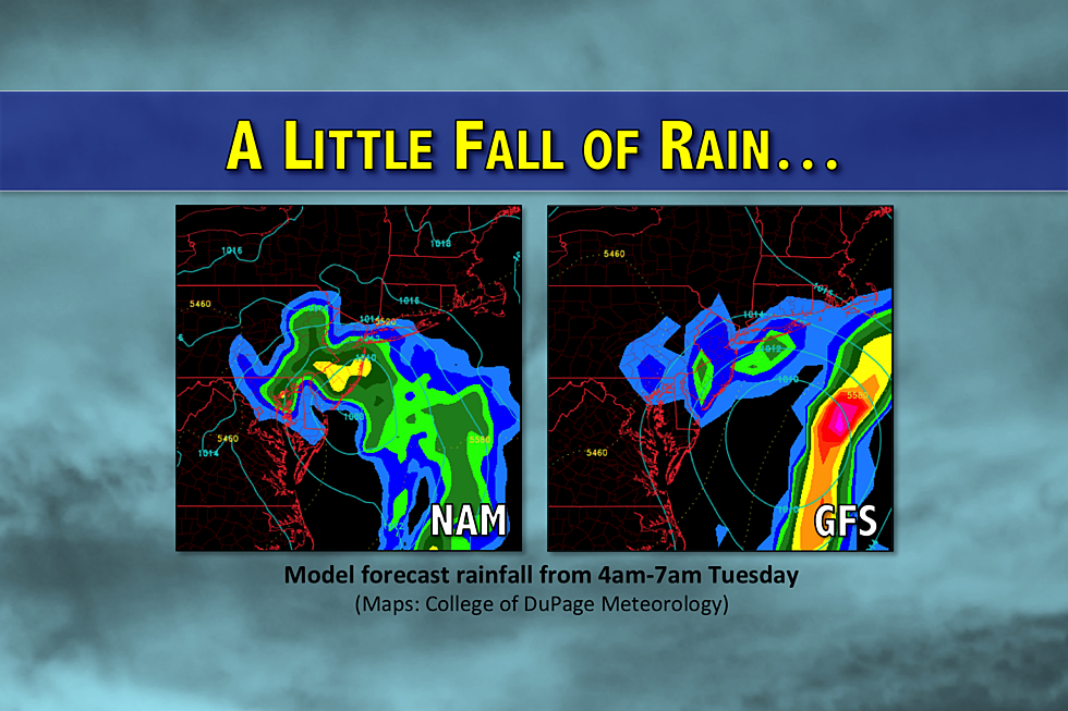
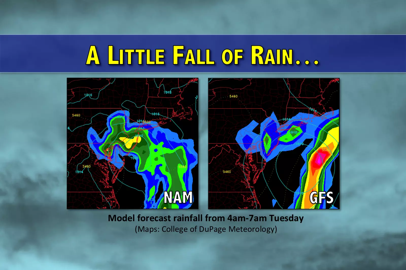
Forecast models depict two potential scenarios for rainfall on Tuesday:
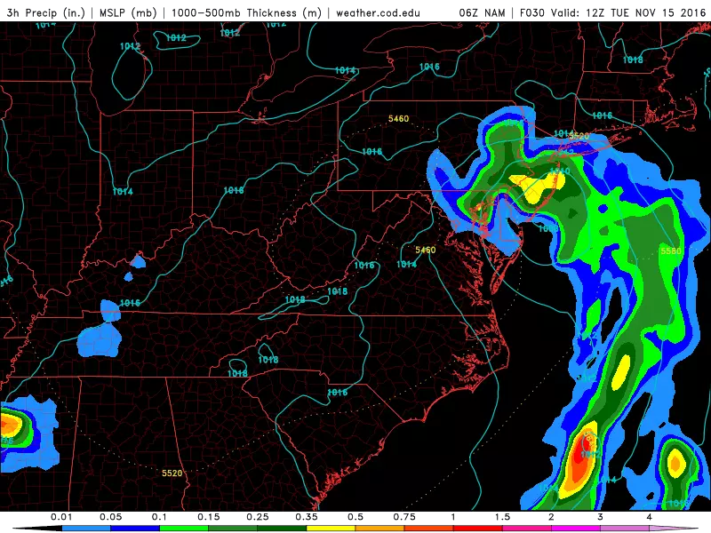
1.) The first scenario - supported mainly by the NAM model - shows the coastal storm system will take an inland path, with the center of low pressure passing right over New Jersey. This would produce a pretty day wet for Tuesday, with periods of light to moderate rain throughout the daytime hours. Just about everyone in the state would get wet, with the heaviest rainfall totals (upwards of an inch) to the south and east.
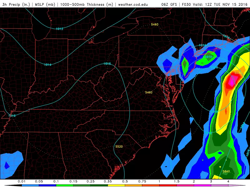
2.) The second scenario - illustrated by the GFS model - keeps the center of this low pressure well off-shore. Such a glancing blow would dramatically decrease rainfall along the western edge of New Jersey. But the Jersey Shore would probably still see showers, at least.
So, it'll be 24 to 36 hours of potentially damp, grey weather. No drought-buster though, unfortunately. In either scenario, rain and clouds will limit high temperatures to the mid 50s on Tuesday afternoon.
Additionally, we'll be on the lookout for rough surf and minor coastal flooding. Tides are already unusually high due to the close approach of the moon - the "Supermoon," as you've probably heard. Add a brisk northeast winds from the coastal low, the scene is set for minor coastal flooding. Key word: minor.
By Wednesday morning, I think the rain will be done. Skies will return to sunshine by Wednesday afternoon, with forecast highs bumping to near 60 degrees.
High pressure will then build in for Thursday and Friday, keeping skies sunny and temperatures seasonable. Thermometers are expected to be near 60 on Thursday and low to mid 60s on Friday.
The forecast for the weekend gets muddled, as we end up right in the middle of two storm systems. Current models suggest little to no rain, but an influx of cooler air is possible (if not likely) at some point Saturday into Sunday. As the week progresses, we'll keep you updated on how the weekend is shaping up.
More From WPG Talk Radio 95.5 FM


![How Early Is Too Early for Christmas Decorations? [POLL]](http://townsquare.media/site/397/files/2016/11/RS2156_137806346-scr.jpg?w=980&q=75)
