
Strong Thunderstorms Return to NJ Tuesday
Yet again, New Jersey's atmosphere is set to get loud on Tuesday, as strong thunderstorms make a big comeback. This forecast is somewhat less severe as we had feared over the past few days — the most powerful storms are now expected to stay away from New Jersey.
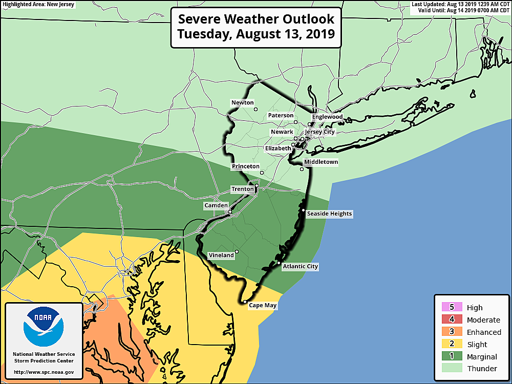
However, I have to stress that we're still facing thunderstorms, severe weather, and flash flooding for much of the state on Tuesday. This is definitely a day to "keep an eye on the sky" and stay "weather-aware".
Tuesday morning is very different than the past few mornings — it is not cool, not comfortable, and not refreshing. That's right, humidity is back! And, of course, that moisture in the air will help to fuel storms later on.
Timing
So the morning hours will be sticky, with scattered showers passing through the state (mainly North Jersey). Thunderstorms will really fire up around midday (11 a.m.), quickly spreading through central and southern NJ. The strongest storms are expected from mid-afternoon (2 p.m.) onward, in the southern half of the state (below I-195). Thunderstorms and rain probably will not exit the Garden State until late evening (after 10 p.m.)

No matter where in the state you live, outdoor activities are going to be challenging Tuesday, especially in the afternoon and evening hours.
Impacts
Our primary concern with Tuesday's thunderstorms will be pockets of torrential rain leading to flash flooding. I have seen model estimates showing local rainfall totals as high as 3+ ... 5+ ... even 7+ inches. Whoa, that's a lot of water! Clearly that much rain would rapidly flood any low-lying areas. Remember to never ever drive or walk through flooded areas — that includes "big puddles" too, which can be surprisingly deep and swift.
The National Weather Service has posted a Flash Flood Watch for 2 p.m. to 10 p.m. for 7 counties in central and southern New Jersey (Burlington, Camden, Gloucester, Mercer, Middlesex, Monmouth, and Ocean). But I wouldn't concentrate too hard on that exact geography — I think the lower tier of counties (Atlantic, Cape May, Cumberland, and Salem) should have been included too.
Another concern is gusty winds both within and in front of thunderstorms, as we've already seen countless times this summer. Downed trees and branches may cause power outages and/or other property damage.
Small hail is possible, but should be limited. And we'd be foolish to rule out an isolated tornado — a quick spin-up, like most of the other 8 we've seen in the state this year. But the twisting potential of the atmosphere should thankfully end up much lower than it had been looking.
After the Storms
Rain will taper off Tuesday evening, from northwest to southeast. (Thunderstorms and steady rain may linger in South Jersey for a while.) We'll probably see some fog develop overnight. Low temperatures will only drop to around 70 degrees.
Wednesday will be a much quieter weather day. There will be a few leftover showers in the neighborhood, especially (but not exclusively) in South Jersey. On the flip side, you might catch some breaks of sunshine, especially in North Jersey. It won't be quite as oppressively humid as Tuesday. High temperatures will end up just shy of normal, in the lower 80s.
I think Thursday has the potential to be a nice day, if we can avoid stray showers. Skies will be partly sunny, with a high temperature near 80 and manageable humidity levels.
We'll remain somewhat unsettled for Friday, with a few spot showers around once again. But for the most part, you'll see a mix of sun and clouds overhead, with highs back in the lower 80s.
The weekend is a puzzlement, but there's still reason to be optimistic. On Saturday, we'll hopefully enjoy more sunshine than clouds with seasonable high temperatures in the mid 80s. I just can't rule out an isolated shower. Sunday looks cloudier and hotter, with the potential for a few 90s on the thermometer. In addition, there's a reasonable chance for some late-day thunderstorms. Again, not perfect, but neither day will be anything close to a washout.
Be safe out there Tuesday, and be sure to keep an ear on your radio and an eye on our web site, social media, and mobile app for the latest storm information.
More From WPG Talk Radio 95.5 FM


