Hermine, the Headache Machine: Yes, Flooding Still a Threat for the Jersey Shore
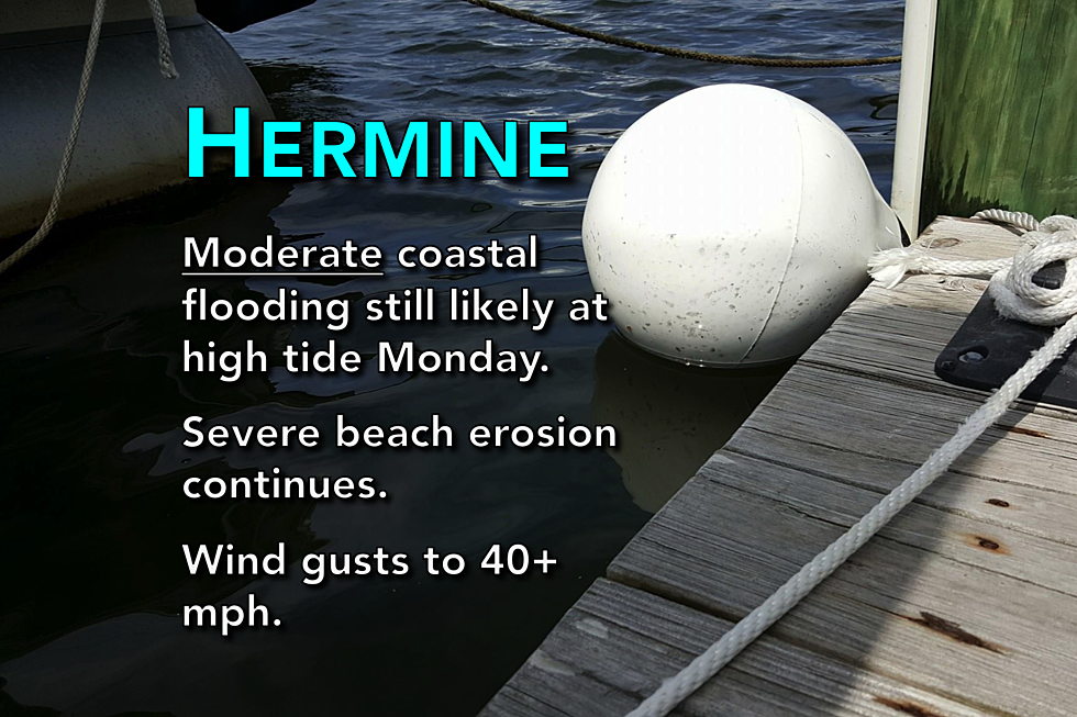
Hermine's off-shore track means NJ will probably avoid 'record' or 'historic' flooding, but water levels at or above 'moderate' flood stage would still be bad.
Here are your latest weather headlines, as Hermine continues to spin about 225 miles off the coast of New Jersey...
Yes, I know it was a beautiful, sunny day
And it was admittedly a surprise. Hermine's clouds mostly stayed out to sea Sunday, while a looser pressure gradient let the winds lighten up from Saturday to Sunday. Waves are still very rough, and beach erosion has been severe in spots.
So sure, I'll be the first to admit that we partially busted the Hermine forecast. I believe I was successful in communicating a level-headed forecast this weekend - the most accurate that science would allow - while never participating in the internet hype machine.
Oh, but wait... The storm's not done yet! For the next 36 to 48 hours, Hermine is going to sit and spin menacingly just east of the Jersey Shore. New Jersey will be under the influence of strong easterly and northeasterly winds, which is still expected to pile a lot of ocean water along the coast. Coastal flooding is still a threat to New Jersey's oceanfronts, back bays, and tributaries, especially in Ocean, Atlantic, and Cape May counties. (Hey, what a coincidence - that's exactly where the State of Emergency has been issued...)
Ultimately, my "best-case scenario" I wrote and published Wednesday morning was almost spot on: "Our weather stays... dry through the entire holiday weekend, although it’s almost certainly going to be rough along the Jersey Shore. Even if the bands of clouds and rain stay over the ocean, a high risk for rip currents will accompany some pretty big waves and possibly... coastal flooding."
Hermine has begun to slow/turn
The 2 p.m. Sunday advisory from the National Hurricane Center had slowed Post-Tropical Cyclone Hermine's forward motion to just 6 mph. The latest advisory, issued at 5 p.m. Sunday, slows the speed to 5 mph, with maximum sustained winds holding steady at 70 mph.
A difference of just 50 to 75 miles further west, and our weather and surf forecast would have been much more severe.
Coastal flooding picture looks better, but still not great
I just took a tour of the latest data at New Jersey's three primary tide gauges: Sandy Hook, Atlantic City, and Cape May. If you want to compare to previous (higher) estimates, I did this same analysis on Sunday morning and Saturday morning.
Forecast tide values are accurate as of 3:20 p.m. EDT, and reference the Mean Lower Low Water datum...
Cape May
--Sunday 11:12 a.m. (Observed) - 6.48 feet (Surge: 0.4 feet)
--Sunday 11:27 p.m. - 6.57 feet (Surge: 0.7 feet)
--Monday 11:50 a.m. - 6.49 feet (Surge: 0.7 feet)
--Tuesday 12:06 a.m. - 7.70 feet (Surge: 2.2 feet) (Moderate Flooding)
--Tuesday 12:30 p.m. - 7.04 feet (Surge: 1.4 feet)
--Wednesday 12:09 a.m. - 5.93 feet (Surge: 0.7 feet)
Atlantic City
--Sunday 10:07 a.m. (Observed) - 5.72 feet (Surge: 0.3 feet)
--Sunday 10:17 p.m. - 5.77 feet (Surge: 0.7 feet)
--Monday 10:45 a.m. - 5.94 feet (Surge: 1.0 feet)
--Monday 10:55 p.m. - 6.78 feet (Surge: 2.1 feet) (Minor Flooding)
--Tuesday 11:25 a.m. - 6.32 feet (Surge: 1.5 feet)
--Tuesday 11:35 p.m. - 5.14 feet (Surge: 0.8 feet)
Sandy Hook
--Sunday 10:34 a.m. (Observed) - 6.04 feet (Surge: 0.1 feet)
--Sunday 10:44 p.m. - 6.75 feet (Surge: 1.6 feet)
--Monday 11:15 a.m. - 6.43 feet (Surge: 1.0 feet)
--Monday 11:27 p.m. - 5.42 feet (Surge: 0.5 feet)
--Tuesday 11:58 a.m. - 5.30 feet (Surge: 0.1 feet)
--Wednesday 12:11 a.m. - 4.81 feet (Surge: 0.1 feet)
So, the bottom line... Tidal waterways will run high between Sunday and early Wednesday, with the surge peaking at 2+ feet during the Monday late evening/Tuesday early morning high tide cycle.
Beaches have already taken a beating
You have probably seen the photos on social media of huge chunks of the Jersey Shore that have been carried out to sea by 10+ foot waves. In that respect, the Labor Day Weekend is not just the "unofficial end of summer" - for some shore towns, the beaches will need serious rehab and replenishment before they are usable for recreation again.
Waves will remain high, rip currents high risk, and beach erosion severe through at least mid-week.
Some wind, maybe some rain, but don't expect much
Winds will kick back up Sunday night into Monday, with gusts to 40 or maybe 50 mph possible (especially along the immediate coast). That's still enough to cause sporadic power outages.
I've said all along that rain wouldn't pose a huge problem, and I still believe that most (if not all) of New Jersey won't see a drop of rain from Hermine. However, some of the forecast models have been wishy-washy about pushing scattered rain bands ashore on Monday. Eh. I don't want to rule out some rain, I'm confident in saying the chance for tropical deluges remains low.
The world is not ending
I have always said that Hermine demanded respect and attention, but never panic. The bump in the coastal flooding forecast was downright scary. And you saw me ramp up my language accordingly. However, as I said Thursday morning, "It’s not Armageddon. It’s not the Storm of the Century. But we all need to take Hermine seriously, and continue monitoring the forecast closely."
Yes, we still need to be vigilant and cautious until the storm moves out to sea on Tuesday. But overall, New Jersey should be very happy now that we will hopefully be spared a direct hit by Hermine.
Unless the forecast or the weather changes significantly overnight, the next weather blog update is expected around 8 a.m. Monday.
More From WPG Talk Radio 95.5 FM