8 things to know about NJ’s snowy, rainy weekend nor’easter
Bottom Line / Changes
Welcome to the first weekend of 2024! It's a messy one weather-wise, as a nor'easter is still on track to deliver snow, sleet, and rain to New Jersey.
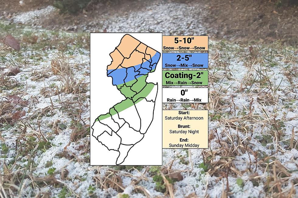
Overall, the outlook has not shifted much. Snow to the north. Rain to the south and along the coast. And a messy mix in the middle, leaning toward the wet side.
Here are the changes I made for this "final call" forecast:
❄️ Tweaked contours slightly, by about 10-20 miles, to account for the latest track and trajectory of the storm.
❄️ Reduced number of map areas from 5 back to 4. Simple is better. And it emphasizes that New Jerseyans north of Interstate 78 (orange and blue) will probably be reaching for the snow shovel. But south of that corridor (green and white) will not.
❄️ Generally decreased expected snow totals. 6-10" became 5-10". 3-6" goes to 2-5". Given the heavy, wet snow ratio - where it even snows - I think it'll be a struggle to see widespread double-digit accumulations.
❄️ Yes, I am leaning toward the lower end of these snowfall ranges. However, those higher elevations of NW NJ in particular have a habit of surprising us with snow totals sometimes. That is why I decided to keep the upper bound snowfall at 10", and structure my contour ranges accordingly.
For the rest of this post, let's run through the 3-part timeline, potential accumulations, coastal impacts, and advisories. And we are still eyeing another, even stronger storm for mid next week.

Phase 1: Saturday Afternoon
Saturday morning is starting off cold, mainly in the 20s. Even colder than ALL models have predicted. That lends credence, I think, to the idea that initial precipitation bands arriving Saturday afternoon will be "mainly snow". (Except, of course, for coastal counties which will probably stay wet.)
Things will get started, as the storm system bubbles up from the southwest around the early to mid-afternoon hours. First flakes and drops will probably be between 1 p.m. and 4 p.m. for most of the state.
A quick "thumping" of snow could produce a quick inch or two of accumulation within the first hour or two. So travel conditions could deteriorate rapidly.
Phase 2: Saturday Night
The brunt of the storm kicks in after sunset, between about 5 p.m. and Midnight. That coincides with the center of this powerful nor'easter passing by the Jersey Shore.
However, that center of low pressure will carry warmer air into New Jersey too. So for most of the state - approximately the area south of Interstate 78 - a transition to plain rain is expected through the evening and overnight hours. That will shut off any additional snow accumulation. (And whatever is on the ground will either melt or become a slushy mess.)
North of I-78 is a little trickier, as additional snowfall through the height of the storm depends on the exact location of the rain-snow line. Some mixing is possible, even as far north as the New York state line. This is a situation where a difference of 5 to 10 miles could make all the difference. North Jersey residents should carefully monitor weather conditions during the storm, and make smart decisions about whether or not it is safe to travel.
Bottom line: Saturday night, the sky is either going to pour rain or puke snow. Not a great time to be out and about, in either case.
Phase 3: Sunday
After Midnight, precipitation intensity should start to calm down, as drier air penetrates NJ's atmosphere and the storm system moves away. As temperatures drop, a transition back to wintry mix or all snow is likely. Even the immediate coast could see a few snowflakes during the day Sunday, in this final phase of the storm.
Snow/mix/rain showers will linger through at least midday Sunday. Maybe even into part of the afternoon. Additional accumulation will be limited, as those showers will be on the light side. Still, watch for visibility and traction issues.
Precipitation will end completely by sunset Sunday. I fully expect road crews to have substantially cleared the snowy areas of the state by Sunday night too. Other than residual icy patches and a potential refreeze, there should be no major issues for Monday morning's commute.
Accumulations
At the top of the state, especially north of I-80 and west of I-287, this storm will produce all snow. That is where at least 5 inches, and up to 10 inches, of accumulation is forecast.
Just south of that, approximately between I-78 and I-80, shovelable snow is still likely. But mixing during the peak of the storm will prevent totals from reaching the "heavy" or "major" category. Expect 2 to 5 inches.
For central and southern New Jersey, it is going to be very difficult for snow to stick around long. I still think a healthy coating is possible, if not probable, at the front and/or back end of the storm. Maybe even an inch or two, if it stays cold enough long enough late Saturday. That is enough to make the ground slick, so it is worth mentioning. Even though it is not even "advisory" level snowfall.
This forecast puts New York City at about 2 inches of accumulation, Philadelphia at maybe a coating (continuing the almost-two-year snow drought there). Trenton and New Brunswick at a slushy inch, and Atlantic City at a big goose-egg zero.
By the way, total rainfall could top an inch in spots. Combined with melting snow, there could be some big puddles around. In addition to slick roadways.
Coastal Flooding
In my estimation, top wind gusts will hit about 30 mph during the brunt of the storm Saturday evening. Blowing out of the northeast, an on-shore breeze.
Is that strong enough to cause massive flooding of tidal waterways at the Jersey Shore? No. But tidal guidance is still showing one round of minor category coastal flooding during Sunday morning's high tide cycle. Maybe an extra one Sunday afternoon, if back bays can not drain completely.
While once a concerning aspect of this storm, this degree of coastal flooding amounts to "the usual places". This nor'easter just is not strong enough, nor taking the "perfect" track, to send a massive wall of water toward our coastline.
Advisories
A Winter Storm Warning, suggesting the possibility of 6+ inches of snow and dangerous travel conditions, covers the following NJ counties for the following times:
— 1 p.m. Saturday to 6 p.m. Sunday... Morris, Sussex, and Warren counties.
— 4 p.m. Saturday to 6 p.m. Sunday... western Bergen and western Passaic counties.
A less-urgent, less-severe Winter Weather Advisory calls for 3+ inches of snow and slippery roads, for the following NJ counties at the following times:
— 1 p.m. Saturday to 6 a.m. Sunday... Hunterdon and Somerset counties.
— 4 p.m. Saturday to 11 a.m. Sunday... eastern Bergen, western Essex, eastern Passaic, and western Union counties.
A Coastal Flood Advisory is also in effect for Ocean County from 2 a.m. to 8 a.m. Sunday, as 1 to 2 feet of surge cause minor flooding of tidal waterways.
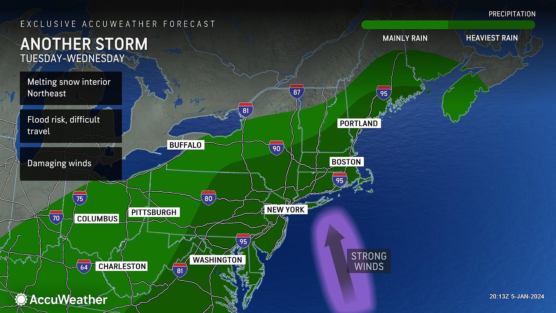
The Next One
An even stronger storm system is set to strike New Jersey between Tuesday afternoon and Wednesday morning. Maybe a hint of snow in colder northwestern New Jersey, but that's not the big deal here.
Heavy rain, on the order of 1 to 3 inches, still looks likely. On top of 50+ mph wind gusts.
Think back to the flooding that occurred in New Jersey in mid-December. Now add 5 to 10 inches of snow to the banks of the Passaic River, all melting rapidly during heavy rainfall. This raises major alarm bells for both flash flooding and river flooding.
In addition, those fierce winds could cause power outages. And the ocean will be all churned up, raising the risk of coastal flooding again. Ocean wave heights are forecast to be huge, potentially causing significant beach erosion too.
Nasty business. And you had better believe I am already using strong messaging, even 3-4 days in advance. While it is not a "snow storm," we can not overlook or underestimate this one. As soon as the weekend storm is over, we will start focusing on detailed impacts.
Be smart and stay safe out there. We will have continuing coverage of this weekend's nor'easter both on-air and online.
Let it snow: 12 things to know about winter forecasting in NJ
Gallery Credit: Dan Zarrow
Dan Zarrow is Chief Meteorologist for Townsquare Media New Jersey. Follow him on Facebook for the latest forecast and realtime weather updates.
Glossary of NJ winter weather words and phrases
Gallery Credit: Dan Zarrow
More From WPG Talk Radio 95.5 FM