
NJ Heat Wave Day 2 of 4: Steamy, Breezy, and Stormy
The Bottom Line
Ready, set, sweat!
The season's first blast of dangerous heat and humidity is here. A few spots in New Jersey hit 90 degrees on Wednesday. And just about everyone — aside from barrier islands — will hit 90+ on both Thursday and Friday. Factor in high humidity, and the heat index soars above 100, into the "danger zone". You have to specifically take care of yourself in such conditions. Dress for the weather, stay extra hydrated, and take frequent breaks. Air conditioning is your friend.
The risk for strong to severe thunderstorms returns on Thursday, too. Fueled by the intense heat and rich humidity in the air, gusty winds and heavy rain are possible.
To answer the inevitable question, relief comes this weekend. Saturday will be a hot, unsettled day. Sunday will turn cooler and more comfortable. That's right, this heat wave will be short-lived.

Thursday
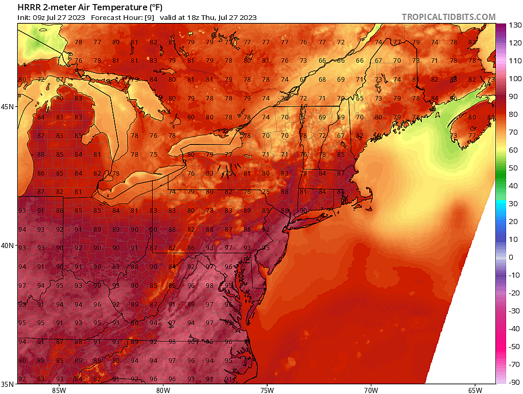
Let me start this steamy forecast by giving you a little climatological context. The weather station at Newark Liberty International Airport is traditionally one of the hottest in the state. At EWR, Thursday will be the second 95+ degree day of 2023. (And Friday will be #3.) On average, Newark sees about seven 95-degree days annually. It has been a tame season so far. And 95+ degrees isn't totally abnormal or anomalous for late July — we are not breaking records here. But you do have to take the heat seriously.
High temperatures across New Jersey will soar to around 90 to 95 degrees Thursday afternoon. (I suspect many places will flirt with 90 by Noon.) As dew points are now in the 70s, you'll be chewing through high humidity too. The heat index (the "feels like" or "apparent" temperature) will aim for a peak around 100 to 105 degrees.
Yes, you will find some relief at the Jersey Shore. Especially on barrier islands, surrounded by cooler water. However, 1.) it's still going to be humid, 2.) it's still the hottest stretch of the year so far, 3.) a prominent southwesterly breeze will drive flies toward the beach, and 4.) a moderate risk of rip currents is posted for Thursday.
An Excessive Heat Warning has been issued for the urban core of NE NJ from 11 a.m. Thursday to 9 p.m. Friday. That includes Bergen, Essex, Hudson, eastern Passaic, and Union counties. (A warning means action, highlighting the seriousness of these hot, humid conditions.)
A less-severe Heat Advisory goes into effect at 11 a.m. Thursday for Burlington, Camden, Gloucester, Hunterdon, Mercer, Middlesex, inland Monmouth, inland Ocean, and Somerset counties. That will be upgraded to an Excessive Heat Warning on Friday from 6 a.m. to 10 p.m.
Coastal Monmouth County is an oddity, under a Heat Advisory from 11 a.m. Thursday to 6 a.m. Friday. (Banking on a more prominent sea breeze during the day Friday.)
A Heat Advisory only also covers inland Atlantic, inland Cape May, Cumberland, Morris, Salem, Sussex, and Warren counties from 11 a.m. Thursday through 10 p.m. Friday.
And western Passaic County falls under a Heat Advisory from 11 a.m. Thursday all the way through 8 p.m. Saturday. (I suspect we will see most of the state join in the advisory for Saturday too.)
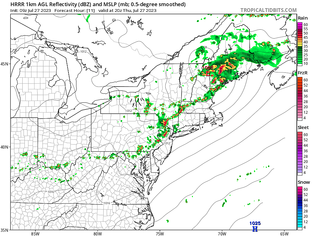
In addition to the heat and humidity, there is a serious concern for thunderstorms Thursday. Given how much energy (heat) and moisture (humidity) will be built up, the atmosphere will be primed to explode.
The time window for potential storms will be about 2 p.m. to 8 p.m. Gusty winds (over 60 mph) will be the biggest concern, with heavy rain a close second. Storms cells should be flying, so any given location should only see about an hour of stormy weather at the most. But that initial burst of wind and rain could pack a punch. Eyes on the sky, please.
Although a storm would rapidly cool down temperatures from the 90s to the 70s, the humidity will remain. So don't expect any "refreshing relief" after a storm passes.
Thursday night will be clear, but uncomfortably muggy. Most of the state will only fall into the mid 70s, with not even a hint of coolness in the air. Urban centers and SW NJ may not fall below 80 degrees — that is downright disgusting.
Friday
Let's do it again. Friday will be a couple degrees hotter. Same level of humidity. Lower chance of storms. And a lighter "blast furnace" breeze.
Look for highs again in the lower to mid 90s. (For the record, I would not rule out 100 degrees somewhere in the state.) The heat index will be back in the triple digits.
Friday will bring partly sunny skies. And there is a chance of a late-day popup thunderstorm. However, storm activity looks far less prominent and less widespread on Friday than on Thursday.
Saturday
One more steamy day. As a cold front approaches, carrying cooler and drier air behind it, a few waves of energy could spark some rain on Saturday.
So you will probably have to dodge showers and thunderstorms are times Saturday. And Saturday night too, where models are picking up on a chance for some very heavy rain through early Sunday morning.
Highs on Saturday will hit the lower 90s. Dew points may be the highest of the week, potentially keeping the heat index right at or above 100.
Sunday
Other than a few showers lingering into Sunday morning, and perhaps some clouds, we can look forward to huge improvements in our weather.
The new air mass arriving in New Jersey will be slightly cooler and much drier. That reduction in humidity will be refreshing. And with high temperatures in the lower to mid 80s, Sunday has the potential to be a beautiful summer day. (Again, as long as those residual showers don't linger too long.)
The Extended Forecast
Pleasant summer weather should continue for the final day of July on Monday and the first day of August on Tuesday. Sunshine, manageable humidity, and lower 80s? Sounds great to me.
There are signals for more unsettled weather through the second half of next week, along with the eventual return of heat and humidity. But honestly, that's so far off — practically mid-August — it's not even worth diving into "possible" details at this point.
Stay cool out there!
Staying Cool In The Heat On The Cheap - 10 Summer Hacks
Gallery Credit: JD Knight
Do not leave these 12 items in your car in the NJ heat
Gallery Credit: Canva
More From WPG Talk Radio 95.5 FM


