
Sloppy Weather For NJ Monday Night: Shovels North, Umbrellas South
The Latest Update
Snow is on the way! And sleet. And rain. As of this writing (6 AM), we are just 12 hours away from a real winter storm — likely the most impactful of the season so far.
Since Sunday morning, I have made a few tweaks to the timing, totals, and impacts forecast. No big changes though. North Jersey looks more snowy than sleety. And we are getting a better picture of where the "mainly wintry" and "mainly wet" cutoff will end up.
Initial showers may arrive by late Monday afternoon. The brunt of the storm will be from Monday evening through early Tuesday morning. And then showers and clouds will linger through at least midday Tuesday.
Mine is notably one of the lower, more conservative snowfall forecasts out there. I am concerned about several factors ultimately limiting snowfall totals:
—Surface air temperatures will remain above freezing for most, making it harder for snow to stick and accumulate. (Although not impossible.)
—Soil temperatures are also relatively warm, lacking any recent cold snap. Current 5cm soil temps are between 33 and 39 degrees. Above freezing.
—Ocean temperatures are unusually warm for late February, between 41 and 45 degrees. With an east-southeast breeze for the duration, coastal areas will be kept too warm for snow or accumulations.
—A period of sleet or icy mix could heavily affect snow totals, as ice pellets do not accumulate as quickly or effectively as fluffy snow.
—The air is pretty dry, lending toward more scattered and less heavy precipitation. (Although the atmospheric column should moisten up as the storm gets going.)
—Snow will be slushy, wet, and heavy. Not dry, powdery, and fluffy. Snow ratios between 6:1 and 10:1.
—This winter has been such a dud. Every single winter storm chance has fizzled and disappointed. Even though this storm presents the best chance for impressive snowfall this season, the pessimistic inertia can't be ignored. (Is that actually a thing?)
Because there are far more reasons against "big snow" rather than for it, I have leaned away from the notions of 8+" of accumulation in North Jersey and 3-5" in NYC.
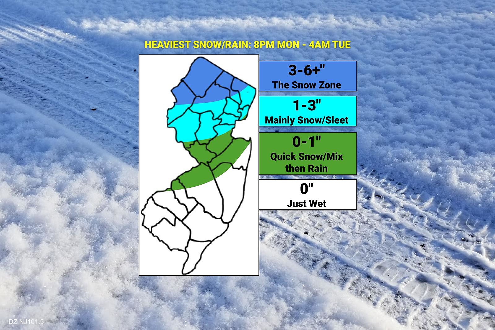
As usual, I will encourage you to blur your eyes when viewing the snow map pasted above. Don't necessarily look at specific numbers — focus on the impacts. Moderate snow accumulations to the north. Light snow/ice accumulations in the middle. Wet, windy weather to the south. Tuesday morning's commute is the big concern, as road conditions could be sloppy.

North Jersey: The Snow Zone
—Timeline... Initial showers may arrive around 6 p.m. Monday evening. Steadier and heavier precipitation — the "brunt" of the storm — will arrive around 8 p.m. Periods of moderate to heavy snow and sleet will continue overnight, tapering somewhat after about 4 a.m. Showers may linger through much of Tuesday, wrapping up between Noon and 4 p.m.
—Totals... 3 to 6+ inches of snow accumulation seems likely. The "plus" reflects a chance for a few spots reaching 7 or 8 inches, if the precipitation type remains straight snow. If any sleet or rain gets involved, I could see final accumulations leaning closer to 3 or 4 inches.
—Winter Storm Warning for Sussex and Morris counties from 5 p.m. Monday through 1 p.m. Tuesday. A warning covers Passaic and western Bergen counties from 6 p.m. Monday through 1 p.m. Tuesday.
—Impacts... This is a "moderate" level event — not major, not minor. Dangerous travel conditions are expected during and after the height of the storm. Visibility may fall pretty low during heavy snow, especially with wind gusts up to 30 mph. While treated roadways should fare OK, plows will be hard at work. And you'll likely need the shovel for the driveway and sidewalk. School closings and delays are likely for Tuesday.
North-Central Jersey: Probably All Wintry
—Timeline... Initial showers may show up on radar starting around 5 p.m. Monday. The brunt of the storm, with periods of steady to heavy precipitation, will be between 8 p.m. Monday evening and 4 a.m. Tuesday morning. During that time, straight snow will likely flip flop with sleet and icy mix, and possibly even some rain. Showers may linger into Tuesday morning, with slow clearing Tuesday afternoon.
—Totals... 1 to 3 inches of snow, with light icing and light rain too.
—Winter Weather Advisory for Warren county from 5 p.m. Monday until 10 a.m. Tuesday. For Hunderdon and Somerset counties from 5 p.m. Monday until 5 a.m. Tuesday. For Hudson, Union, Essex, and eastern Bergen counties from 6 p.m. Monday until 1 p.m. Tuesday.
—Impacts... This is a "minor" level event. Slushy and sloppy. Treacherous travel is possible during and after periods of snow, sleet, and freezing rain. Visibility may fall pretty low during heavy snow, especially with wind gusts up to 30 mph. While treated roadways should be fine, plows and salters will be out and working. You probably will not need the shovel Tuesday morning. I wouldn't rule out some precautionary closings, cancellations, and delays.
Central-South Jersey: Quick Mix then Rain
—Timeline... Showers arrive from the southwest around dinnertime Monday, around 5 p.m. Periods of moderate to heavy rain will take over during the brunt of the storm between 8 p.m. Monday and 4 a.m. Tuesday. Close to onset, a brief period of wintry mix is possible. Likely no more than an hour or two, if that, before changing over to plain rain through the overnight. Showers linger for a bit Tuesday, but expect slow clearing into the afternoon (especially away from the coast).
—Totals... Snowfall in this area will range from absolutely nothing to possibly an inch. Leaning more toward the bottom end of that range, as this area of the state does look primarily wet.
—Advisories... None.
—Impacts... Potentially sloppy conditions, but not really wintry. Breezy, chilly, and wet. I am playing it cautious, leaving that chance for some quick snow or wintry mix on the frontside of this storm system. But road conditions should stay primarily wet for the duration. I don't expect any significant problems for Tuesday morning's commute. Nor should we see any school closings or delays in this area.
South Jersey: Wet
—Timeline... Rain showers may bubble up from the southwest starting around 4 p.m. Monday. Rainfall will become more widespread, steadier, and heavier as night falls, especially after 8 p.m. The brunt of the storm will last through early Tuesday morning, around 4 a.m. Rain showers may linger through the AM commute, but slow clearing will take over by Tuesday afternoon.
—Totals... Zero snow. Zero ice. A half-inch to an inch of rainfall.
—Advisories... None.
—Impacts... It's just rain. Surface air temperatures will not drop below 40 degrees, well above freezing. Still, roads may be slick due to wetness. And 30 mph wind gusts will contribute to an overall inclement night.
Forecast Confidence
I feel pretty good about my forecast. Although it is unsettling that some forecasters feel higher snow totals will ultimately win out across the board in North Jersey, and I don't fully understand why.
There is uncertainty baked into each of my four forecast regions above. Will North Jersey end up overperforming, with a wide swath of 8 inches rather than just 6? Will the middle zone of the state also see more snow than sleet/rain, or vice versa? Will wintry mix linger longer or end sooner along the I-195 or I-295 corridors? Will South Jersey see a half-inch or a full inch of cold rain?
If you're on the wintry side of the state, you might want to set your alarm clock a bit earlier for Tuesday morning, to allow for extra travel time.
What's Next?
Weather conditions will improve Tuesday afternoon, with most high temperatures pushing back into the 40s. (Although with fresh snow cover, North Jersey will probably max out in the 30s.)
Wednesday looks like a nice day, with partly sunny skies and highs pushing toward 50 degrees.
Thursday brings a quick hit of rain in the morning, then mild temperatures approaching 60 in South Jersey.
And our next storm system of consequence is forecast to arrive on Friday. Once again, there could be some messy, wintry weather involved. Once again, especially for North Jersey. Let's continue to play this out one storm at a time — we'll start talking about the late-week storm once the early-week storm is out of our hair.
Be smart and stay safe out there. This will be my last full weather blog update on this storm — but our team will be on top of the changing, wintry, wet weather conditions from start to finish. On-air, on the web and our mobile app, and on social media too.
Final flakes: When does snow season end in NJ?
Gallery Credit: Dan Zarrow
First flakes: When does snow season start in NJ?
Gallery Credit: Dan Zarrow
More From WPG Talk Radio 95.5 FM


