Stormy Sunday for NJ But the Rest of the Weekend Looks Great
Periods of rain and gusty winds are expected all day Sunday, with the potential for some truly torrential rain Sunday evening.
Here are your weather headlines for Friday, October 27, 2017...
For Now: Nice Weather
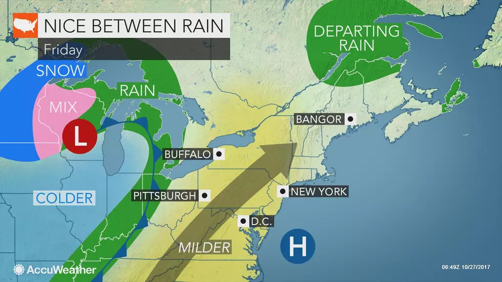
Our Friday forecast begins with a return to crystal clear skies and a taste of seasonable Fall temperatures! Friday morning is definitely chilly, with most of NJ in the 30s. Some spots have experienced a frost, and a few temps have even fallen to the freezing mark. Definite a "jacket morning".
By Friday afternoon, sunshine and dry air will warm thermometers into the lower to mid 60s. Normal highs for Friday are 62 at Newark, 62 at Trenton, and 63 at Atlantic City, so I'll call it a pretty typical late October day. Pretty pleasant too.
With a touch of humidity in the air Friday night, temperatures won't be as chilly as Thursday night. Overnight lows are forecast to dip into the upper 40s to around 50 degrees.
Saturday's forecast also looks great. It will be a breezy and mild day, as temperatures make a run for 70 degrees by the afternoon. Clouds and wind speeds will ramp up by Saturday afternoon. I can't rule out a few showers encroaching upon New Jersey's borders Saturday evening.
Sunday: Setup
I think it's safe to call Sunday a wet and windy day — close to a total washout, although I do think there will be breaks in the rainfall action. Some have been hyping this storm, even comparing it to Superstorm Sandy. But the only thing the two storms have in common is the date — October 29th.
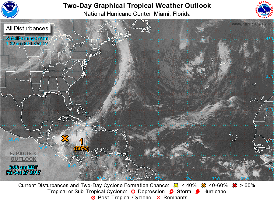
There are two storm systems at play for Sunday's stormy forecast. The first is a cold front coming from the west. The second is a tropical disturbance, currently spinning over the western Caribbean Sea, expected to ride north along the U.S. East Coast through the weekend.
The biggest questions regarding this forecast surrounds the timing, track, size, and intensity of storm system #2. Will it phase perfectly with the front, passing close enough to New Jersey to significantly enhance rainfall? The Euro and NAM models say yes, the GFS says no.
Another important question: Will system #2 become a named tropical storm? Maybe. (The next name on the list is Philippe.) If it gets a name, watch the internet hype train go off the scales this weekend...
Sunday: The Sure Bet
Again, Sunday will be wet, windy, and pretty yucky overall. (Kind of similar to this past Tuesday, actually.) Bands of steady rain could arrive as early as 5 a.m. and soggy weather looks to continue throughout the day.
Rainfall totals in this scenario would end up in the half-inch to inch range. A gusty wind will kick up too, as high as 45 mph. With marginal instability in the forecast, don't be surprised to hear a few rumbles of thunder along the way too.
Rain would taper off Sunday night, ending completely with lingering showers Monday morning.
Sunday: Worst-Case Scenario
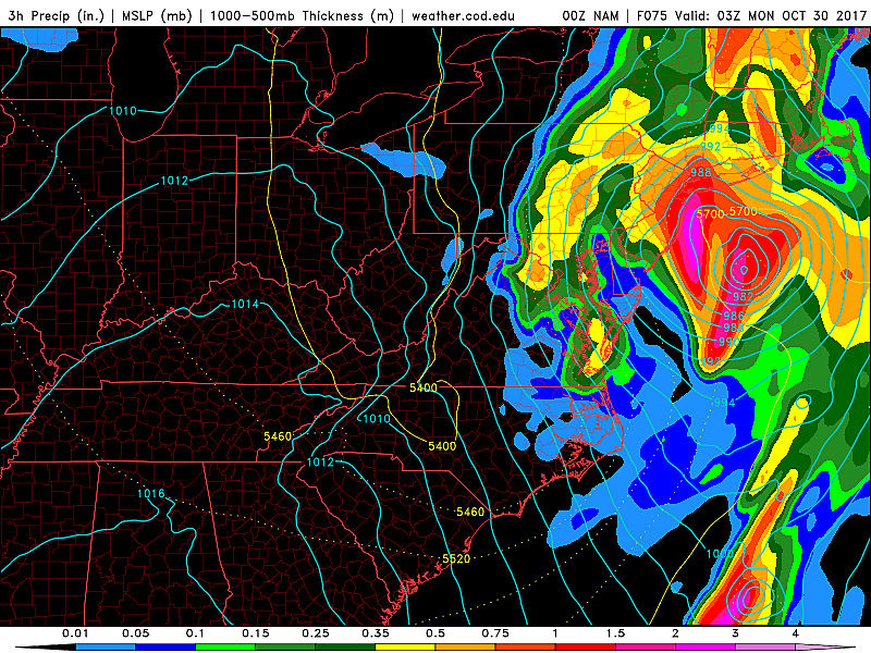
Any system of tropical origin warrants extra attention due to the threat of very heavy rain. If the aforementioned tropical disturbance passes close enough to (or over) New Jersey, a period of truly torrential rain will be possible Sunday evening (starting around 5 p.m. or so). And yes, in this solution, widespread rainfall totals would realistically end up in the 3 to 5 inch range. The greatest threat for heavy rain would be closest to the center of the coastal storm system — i.e. along the Jersey Shore.
The latest NAM model falls into this category. But the output seems a little wonky to me, so I'm more of less ignoring it. Of course, the almighty Euro also paints this very wet scenario, which means it is absolutely in play.
Sunday: Additional Considerations
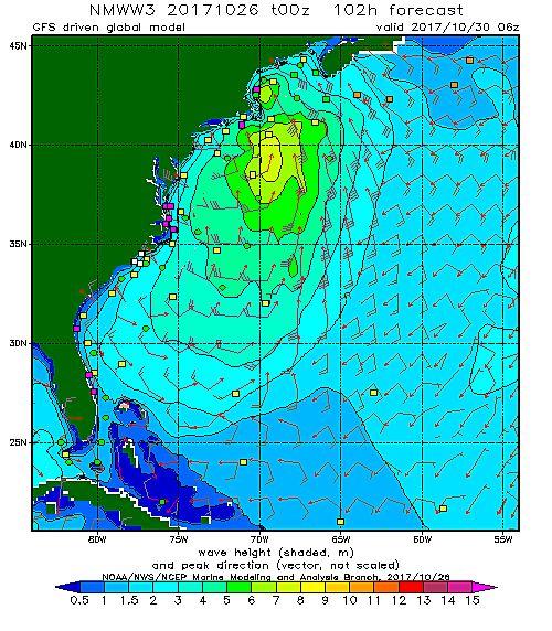
In terms of a coastal flooding or storm surge threat, the forecast remains in a holding pattern until one of the above scenarios becomes the dominant forecast. The WaveWatch III wave height model I've posted here initializes off the GFS model — that is the tamer, farther off-shore solution as I mentioned above. Imagine those 6 to 10 foot waves coming closer to the Jersey Shore. That push of water could push coastal flooding into the "minor" or "moderate" category. (In other words, the "usual" places would flood at high tide, and that's it.)
In terms of an inland flash flooding threat, I like what I see. The "antecedent condition" (i.e. how wet the ground is right now) is unsurprisingly dry. That means the ground will easily soak up a couple inches of rain before widespread flooding becomes a major concern. If the high end of the worst-case scenario comes true, we might have some trouble as storm drains become inundated. Five inches of rain is going to cause flooding, no matter how dry the ground it.
Bottom line... I'm trying to present a calm, realistic analysis of what is likely to transpire for the second half of the weekend. This pair of storm systems will turn Sunday into a messy day. But the threat for truly dangerous, batten-down-the-hatches type of weather? Limited.
Next Week: Even Cooler
Behind the wet and windy weather and behind the cold front will come another burst of chilly air. As showers end early Monday morning, skies should begin to clear quickly. Despite the return to sunshine, temperatures will struggle to reach 60 degrees.
Your Halloween forecast is sunny and quiet, but cool. High temps will probably be limited to the 50s — and remember, it will already start to cool off by "trick or treat time" Tuesday evening.
More From WPG Talk Radio 95.5 FM