
Summerlike NJ weather as temperatures and humidity continue to rise
The Bottom Line
If you like it warm and summerlike, you are going to like this weather forecast. A few spots in New Jersey hit 80 degrees on Monday. Many more will exceed that benchmark on Tuesday. In fact, every day in the next week has a shot at somewhere in NJ reaching 80+.
Humidity will rise too — meaning it will feel stickier, you will sweat more, and you might be reaching for the air conditioner during the heat of the day.
New Jersey's weather will stay completely dry and sunny for another day and a half. But eventually we will have to add thunderstorm chances into the mix. Specifically on Thursday.
The holiday weekend forecast is still fuzzy, but there are some trends emerging. It will not stay completely dry. But it will not be a washout. It will not be as warm as earlier in the week. But it will not turn miserably cool either.
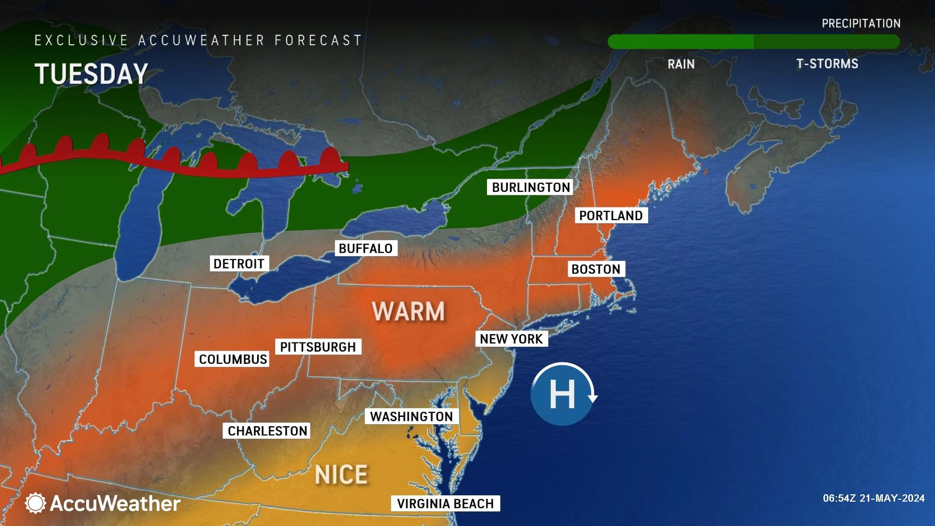
Tuesday
Tuesday's weather will look just like Monday's, only a few degrees warmer.
The only weather nuisance heading out the door Tuesday morning is some patchy dense fog. Any reduced visibility and low clouds should lift quickly by mid-morning, resulting in another bright and sunny day. It will be completely rain-free.
Meanwhile, temperatures are starting in the comfortable 50s. And we will top out in the lower 80s across New Jersey — more typical of late June than late May. (It might be a little difficult to dress appropriately for that big swing in temperatures — but I'm sure you'll manage.)
The sea breeze machine will fire up Tuesday, thanks to light winds, abundant sunshine, and cool ocean temperatures. That means towns along the eastern and southern edges of New Jersey will end up far from that 80-degree mark. Closer to 70, in fact. Still a nice day, just cooler.
Tuesday night will stay quiet, with a few clouds building in. Low temperatures will dip to around 60 degrees. Again, nice and comfortable.
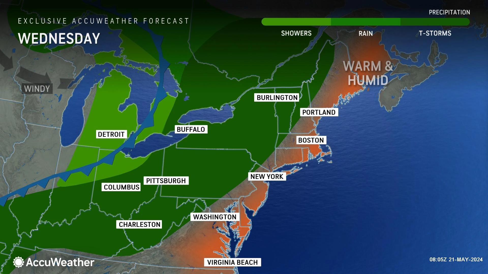
Wednesday
Wednesday turns even more summerlike, as both temperatures and humidity tick up another notch.
Look for highs in the mid 80s — akin to a typical mid-summer day. Dew points will rise far into the 60s too, adding a definite "sweat factor" to the air.
Once again, the day looks mostly sunny overall. Latest model guidance suggests a popup thunderstorm is possible Wednesday evening. It looks like an isolated threat, but something to watch.
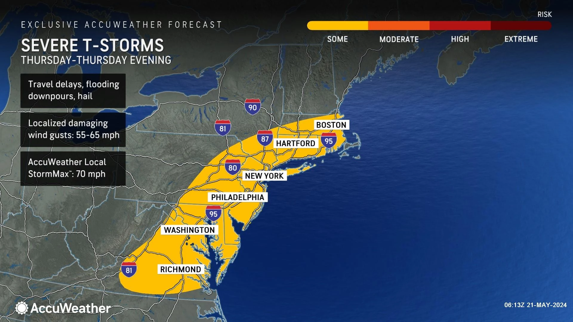
Thursday
Thursday will not only be steamy, but also stormy.
High temps will once again shoot into the mid 80s, with moderate to high humidity continuing as well. But this time, skies will turn mostly cloudy.
In addition, an approaching cold front is expected to fire off a line of thunderstorms, most likely in the afternoon and evening hours Thursday. (For now I will give you a time window of 2 p.m. to 10 p.m. but that is a rough estimate.)
Given the heat and humidity fueling those storms, they will probably reach strong or severe limits. As storms travel from west to east across New Jersey, localized downpours and some gusty winds are likely.
Behind the front Thursday night, our weather will dry out and skies will clear. But don't expect the air to cool down to dry out much.
Friday
Friday we should flip back to pleasant, unseasonably warm weather. Under a mix of sun and clouds, high temperatures should settle back into the lower 80s. An isolated shower is not impossible, but I favor another completely dry day to close out the workweek.
The Weekend & Beyond
The Memorial Day Weekend is looming nearer. And there is still a lot of "wobble" among model forecasts. In other words, each model run and each forecast model shows a different scenario playing out. (Sometimes wildly different, in terms of rain timing and resultant temperatures.)
Here is the general trend I am liking for now — and keep in mind, we will continue to refine this forecast as the week rolls on.
Saturday will be mostly cloudy, with spotty showers around both early and late. High temperatures will be in the 70s — so as long as the rain is not too prolonged and we see some peeks of sun, there will be a period of very nice weather.
Sunday is trending dry, with increasing sunshine and highs back in the 80s. An early morning cold front will cause humidity levels to dial back. As long as the rain-free forecast holds, it could be the nicest day of the holiday weekend.
Memorial Day Monday, however, is looking rainy. A pocket of heavy rain is possible at some point, pushing rainfall totals toward an inch. But models vastly greatly in terms of time. That will be critical, especially given how many outdoor parades and remembrance ceremonies are scheduled around the Garden State.
NJ Street Fairs are back! See the latest 2024 schedule
Gallery Credit: Mike Brant
Memorial Day Parades in New Jersey 2024 (alphabetical)
Gallery Credit: Dan Alexander
More From WPG Talk Radio 95.5 FM


