Wind Advisory: 50 MPH Gusts and Flurries Possible for NJ Wednesday
Hello and happy Wednesday morning! I'm glad you didn't get blown away Tuesday — wind gusts topped 30 mph across most of New Jersey. (Top gust was 47 mph at High Point.)
Wednesday will be even windier, with potential gusts to 40 or even 50 mph. So yes, you'll have to hold on to your hats, garbage cans, Christmas decorations, and shopping carts. Those gusts might be high enough to make driving or walking difficult. Worst-case scenario, shingles and tree branches might become dislodged.
A Wind Advisory is in effect for central and southern New Jersey until 4 p.m. Wednesday. That includes Atlantic, Burlington, Camden, Cape May, Cumberland, Gloucester, Hunterdon, Mercer, Middlsex, Monmouth, Ocean, Salem, Somerset, and Warren counties.
While I'm on the topic of advisories, it's worth mentioning that we still have several active Flood Warnings, as numerous NJ waterways remain above flood stage. That includes:
--Maurice River at Norma (Central Cumberland, East-Central Salem)
--Pequest River at Pequest (Central Warren)
--Great Egg Harbor River at Folsom (West-Central Atlantic)
--North Branch Rancocas Creek at Pemberton (Burlington)
--Passaic River at Little Falls (Essex, Passaic)
--Passaic River at Pine Brook (Essex, Morris, Passaic)
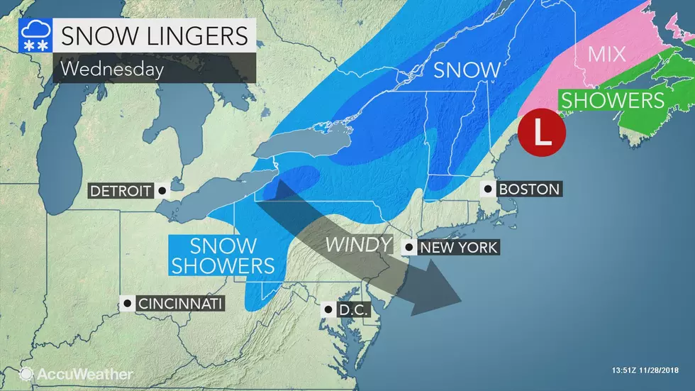
The reason for the wind, by the way, is a powerful storm system centered over New England. So far, we've just missed out on any precipitation from this system. However, a few snowflakes (gasp!) have been reported around North Jersey Wednesday morning. Nothing more than flurries are expected through the first half of the day. (Why is the state brining the roads again, for flurries? No clue.)
The rest of the day will feature a mix of clouds and sun — North Jersey will be cloudier, South Jersey will be sunnier. High temperatures Wednesday afternoon will be limited to the lower 40s (maybe mid 40s to the south). When you factor in that brisk westerly wind, the wind chill (or "feels like" temperature) will be stuck in the 30s, at best, all day.
Wednesday night, the wind will die down only slightly — so we'll have to battle a chilly, biting breeze once again. Clearing skies will allow thermometers to drop into the lower 30s. Wind chills will probably fall into the 20s across most of the state.
I'm calling Thursday breezy — with sustained winds of 10 to 20 mph and gusts to about 25 mph, it won't be as gusty and blustery and uncomfortable as Wednesday. In addition, we'll enjoy lots and sunshine and a slight warmup to the upper 40s by Thursday afternoon. Not bad and almost seasonable — normal high temps for late November are 49 to 52 degrees.
Winds will finally become calm by Friday. As clouds increase, high temperatures are forecast to only reach the mid 40s.
I've been tracking a weak atmospheric disturbance passing through New Jersey Friday night. The latest model guidance shows this chance of showers to be fizzling. (NAM is completely dry, and GFS paints widely scattered showers Friday evening.)
The better chance for wet weather will come over the weekend. Saturday will start cloudy and dry. With a subtle on-shore flow (wind blowing off the ocean), temperatures will moderate to the lower 50s. Humidity will uptick as well.
So as our next storm system arrives, the threat for steady-to-heavy rain and possible flooding is back on the table for the second weekend in a row. I'm seeing showers enter New Jersey around Saturday afternoon, with the heaviest rain expected Saturday evening through the overnight hours. There could be lingering showers through the first half of Sunday too.
However, Sunday afternoon could become the shining star of this forecast. With partial clearing, a drier atmosphere, and a light southwesterly breeze, temperatures could (temporarily) spike. My latest forecast calls for mid 60s — that would be our warmest day in about a month!
The long-range forecast shows a pair of potential snow makers in the neighborhood Tuesday (12/4) and next weekend (12/8-12/9). Just something to watch!
More From WPG Talk Radio 95.5 FM