
Another Tricky Nor’easter, Another Shot of Snow
Another weekend is upon us. And there's another snowstorm in the forecast. Another nor'easter. 'Tis the season, I suppose.
This coastal storm is different than the long-duration, high-impact winter storm that clobbered the state earlier this week. (A "Miller Type A" vs. the previous "Miller Type B" track.) While we've been watching the development of this weekend's storm since Monday, it wasn't until Thursday afternoon and Friday morning that it became clear this coast-hugger system would bring wintry weather to New Jersey.
So at this point, we have determined that the storm will have some impact. (It's a "hit".) And as of this post, we have a pretty good sense of the timing. All that's left is to nail down accumulations and impacts.
I've taken a stab at snowfall totals. But this is the kind of storm where the precise track will have a huge impact on totals. A "wiggle" of 25 to 50 miles will make all the difference between getting buried and busted here.
Needless to say, these are not my favorite storms to predict. But let's give it a shot...
Timeline
This is the straightforward part. (I'll never call a snow forecast "easy".) Our initial band of precipitation will arrive early Sunday morning, spreading from south to north between about 2 a.m. and 6 a.m. (Initial precipitation type may be rain or mix, but that will quickly flip to an almost all snow event.) The brunt of the storm will be firmly in the Sunday morning hours, between about 8 a.m. and Noon. Final flakes will taper off Sunday afternoon, between about 1 p.m. and 4 p.m.
I do want to comment on something I've seen across social media. Some are dubbing this storm after a certain Big Football Game that also happens to be on Sunday. There is a certain appeal to using the name of that event, "snow," and "Sunday" given the alliteration. However:
1.) The league of football in this nation holds the trademark on that name, and they aggressively litigate against illegal and inappropriate use. While news organizations and non-commercial mentions are generally safe, using such a moniker to specifically brand and promote your coverage is a gray area.
2.) The snow is going to wrap up several hours before kickoff. Especially the heavy stuff. So I feel it's a little deceiving to connect the sporting event to the weather event, when they aren't happening at the same time. (In New Jersey, at least.)
Most Likely Scenario
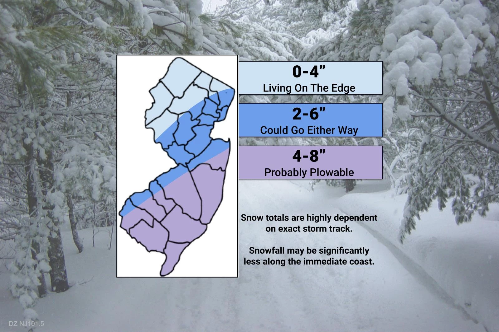
For my first stab snow map, I opted for wide areas of overlapping snow totals, aiming for what I consider to be reasonable, midrange estimates of total snowfall. The snow bullseye looks to most likely land over interior South Jersey, with upwards of 8" of snow accumulation. It's been a while since we've had a South Jersey Special!
There are some models that paint up to a foot of snowfall over NJ. Namely the NAM, which can be scarily good at identifying and forecasting heavy snow bands. I'm not ready to go there. Yet.
Similarly, I do believe zero snowfall is on the table for northern New Jersey here.
Another consideration here is precipitation type. The temperature profile of the atmosphere seems to be pointing toward a snowy (rather than rainy or sleety) event. But there are two exceptions:
1.) Temperatures may not be cold enough at onset Sunday morning for all snow. You might encounter rain or wintry mix for a couple of hours, before flipping to all snow. I don't think this would have a significant impact on snow totals.
2.) The coast will be under the influence of a (relatively warmer) ocean breeze for part of the storm. That may keep the few miles right along the coast just warm enough for rain/mix, rather than snow. This could result in significantly low snow accumulation along and east of the Garden State Parkway.
If the Storm Wiggles
Due to technological and logistical concerns, I've never tried this before. But watch what happens if I manually "wiggle" my snow forecast about 50 miles in either direction.
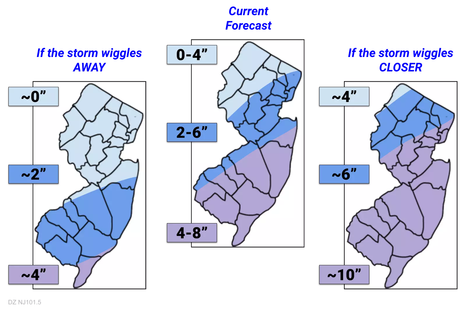
The drawing is admittedly a little rough. And the numbers are even rougher, just estimates. But hopefully that gives you a sense for how our snow forecast may shift going forward, as the storm track drifts either closer to (northwest) or away from (southeast) New Jersey.
Winter Storm Watch
Since it is likely that we have substantial snowfall within 48 hours, the National Weather Service issued a Winter Storm Watch for most of the state:
—Midnight to 4 p.m. Sunday... Atlantic, Burlington, Camden, Cape May, Gloucester, Hunterdon, Mercer, Middlesex, Monmouth, Ocean, Salem, Somerset
—4 a.m. to 6 p.m. Sunday... eastern Bergen, Essex, Hudson, eastern Passaic, and Union

For the record, I think it was smart and necessary for NWS to issue such a blanket watch at this stage of the game, given the uncertainty of the storm track and potential accumulations. I'm not 100% in agreement with the geography nor the timing of their forecast here. But I expect when warnings and advisories are issued on Saturday, they will be much more targeted and specific.
Other Impacts
There might be a brief period of 30+ mph wind gusts. Not terrible.
But because this storm is flying by rapidly, it's not expected to push a lot of ocean water toward the Jersey Shore. I am encouraged by storm surge estimates less than one foot. Tidal guidance suggests one round of rough surf and minor coastal flooding behind the storm Monday morning, but that's it.
It is going to turn cold and windy behind the storm, as arctic air returns to the Garden State. Not quite "dangerous" cold, but certainly blustery and unseasonable. Monday morning's low temperatures will probably dip into the teens, with wind chills possibly in the single digits.
A Few Reminders
I consider anything over 6 inches a "major" snow event. Travel will be difficult and dangerous, traffic will be snarled, and plows will have to hit the road. So this is where we'll target the forecast going forecast — who is most likely to see "major" snow, and who will end up in the "minor" or "moderate" category.
It's also important to remember how much snow is still on the ground in North Jersey. We've had some good snow melt over the past three days. But there's not much room for plows to put more snow. If Sunday's nor'easter wiggles north toward the snowier solution, more serious and prolonged impacts are possible because of that fact alone.
Finally, please under this is an exceptionally difficult and sensitive forecast. Because of the nature of this "Miller Type A" nor'easter and the sudden shift in track, the "wiggle factor" is more important here than ever. This forecast will change and evolve between now and the start of the storm. New data, new information, and new analysis will always result in a new outlook. That's just how weather forecasting works.
What's Next?
We'll use both Saturday morning's and Saturday afternoon's forecast model runs to zero in on the precise storm track, moisture content, and temperature profile. I'll probably put out a new weather blog around midday Saturday, with a more refined and more confident snowfall forecast.
Until then, enjoy your Friday night and have a great weekend.

LOOK: The best drinks to get you through the storm
More From WPG Talk Radio 95.5 FM


