
NJ aiming for 100° Tuesday: When will storms and cooldown arrive?
The Bottom Line
Heat. Humidity. Thunderstorms. Classic New Jersey summertime weather.
But as I have been stressing for a while, this week's heat and humidity goes far beyond typical summer weather. Temperatures are running 10 to 15 degrees hotter than normal, close to the triple-digit mark and close to record highs. Humidity is high, pushing the heat index into the "danger zone".
And the steamy weather has been so persistent. On 11 of the last 12 days, the thermometer hit 90+ degrees somewhere in New Jersey. Tuesday will easily be #12 and Wednesday will be #13, before some relief.
We do have two opportunities for stormy weather coming up. One Wednesday night, from a decaying cluster of powerful storms that smacked the Midwest. And one late Thursday, which could produce some heavy rain before ushering in the cooldown we crave.
The heat wave ends in less than 48 hours. Hang in there, take care of yourself, and look forward to some beautiful summer weather coming up later this week.
Tuesday
It is already hot on this Tuesday morning, with temperatures near 80 degrees between the NJ Turnpike and the coast. That would be typical of an early June afternoon. But in the morning? It is uncomfortable, and a signal that this will be another ferociously hot day.
Most of New Jersey will shoot into the upper 90s to around 100 degrees Tuesday afternoon. The dew point will actually dip slightly, decreasing from what I would call "tropical" to just "steamy". In other words, there will not be much appreciable difference. Especially given the hot air mass that continues to build in.
The heat index (the "feels like" or "apparent" temperature) is expected to hit 110 degrees again Tuesday afternoon. Downright dangerous heat. Excessive heat warnings and heat advisories are in place for almost the entire state.
You will find some relief at beaches and on barrier islands.
The bulk of the daytime hours look sunny, with an increasing southwesterly breeze through the afternoon.
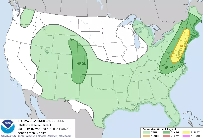
There is a chance of a thunderstorm after about 5 p.m. Tuesday, centered on the evening hours. I am not convinced this complex of rain will make it through New Jersey before it completely falls apart. But just in case, it is worth mentioning. Especially since if a storm does arrive, it could be on the strong side with a quick downpour, wicked lightning, and gusty winds. The Storm Prediction has even pegged New Jersey with a "Slight Risk" (level 2 of 5) on Tuesday's severe weather outlook.
The rest of Tuesday night will be partly cloudy and muggy, with lows again in the 70s.
Wednesday
The final day of this heat wave will be slightly more tame than Tuesday. But we're still looking at high temperatures in the lower to mid 90s. That still puts the heat index over 100.
Most of Wednesday will feature a mix of sun and clouds.
Eventually, as a cold front approaches from the west, a widespread line of strong thunderstorms will roll into New Jersey. There is one model solution — the Euro — that puts stormy weather over New Jersey in the early afternoon. Everything else is pointing to a start time around 4 or 5 p.m. (And I tend to agree with that traditional "late-day" timing.)
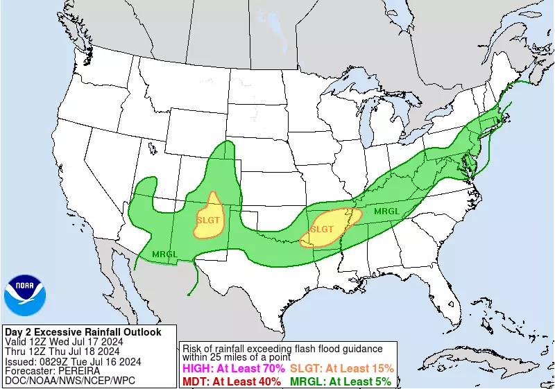
I am very concerned about heavy rain here. Mesoscale models are pumping out multiple inches of rain in pockets from Wednesday afternoon through late night. That is more than enough to cause ponding and flooding issues through the evening commute and beyond. Not everyone will see 2 to 3 inches of rainfall necessarily, but the atmosphere will be very moisture-rich.
You will not feel much relief from the humidity as a result of Wednesday night's storms. As scattered rain persists overnight, most low temperatures will again only dip into the 70s.
Thursday
Our big cooldown day — a time of celebration, rebirth, and jubilation!
The transition to nicer weather will be a slow one Thursday. Showers may linger through mid-morning Thursday, then clouds will give way to sunshine.
Meanwhile, humidity levels will gradually dial back, as dew points slip from near 70 in the morning to near 60 by late-day.
High temperatures on Thursday will "only" reach the mid 80s. I use the quotation marks, because that is still seasonably warm and summerish. But not nearly as hot as some of our recent 90+ degree heat wave days.
Friday
Friday is, hands down, New Jersey's weather winner of the week. The forecast calls for sunshine, low humidity, dry weather, and seasonably warm temperatures.
Look for highs in the mid 80s. Yes, it will still feel like summertime and you will still sweat. But this is typical summer weather — and you really can't complain about near-normal temperatures at any time of year.
The Weekend & Beyond
I like what I see for the bulk of the weekend so far.
Temperatures will start creeping up again. And humidity levels will bounce up slightly, as dew points push into the sticky 60s again.
Right now, my forecast shows partly sunny skies and upper 80s on Saturday. Followed by mostly cloudy skies and 85 to 90 degrees on Sunday.
There is a chance of rain popping up Sunday too. But it does not look to be all that widespread or prolonged.
Extreme heat should stay away next week, with highs mainly in the 80s. But I have a sneaking suspicion we are not quite done with widespread 90s and even 100s here in the month of July.
Is Disney's 'Cafe May Cafe' a real taste of New Jersey?
Gallery Credit: Dan Zarrow
11 reasons why storm chasing in NJ is a very, very bad idea
Gallery Credit: Dan Zarrow
More From WPG Talk Radio 95.5 FM


