Another Windy Day for NJ: 40 MPH Gusts, Possible Snow Squalls
UPDATE as of 2:35 p.m. Saturday...
UPDATE as of 1:45 p.m. Saturday...
ORIGINAL POST from 8:45 a.m. Saturday...
We dive into the President's Day Weekend with a somewhat active, somewhat wintry, somewhat tricky day of weather. As a clipper system passes north of New Jersey, we'll feel the effects of a weak cold front and reinforcing shot of cold air.
Once again, there are alarm bells ringing for gusty winds. And the chance for a squall line — a narrow, but intense, band of precipitation. But this time around, with the return of cold air, such a squall would likely fall as snow instead of pouring rain.

I'm not sure Saturday's weather will be necessarily "dangerous" — although that depends a lot on where you are, and what you're doing. But it's definitely worth an extra "heads up" so you can stay "weather aware" and safe.
Snow
Yes, we're talking about snow here, even with temperatures at or above 40 degrees. Remember that precipitation type is much more dependent on the temperature in the "snow growth zone" a mile up in the atmosphere, rather than at the surface.
Let me also say that Saturday's squall line will not be as strong and intense as Friday morning's. That 10 minutes of torrential rain was insane! Different setup, different dynamics in play this time around.
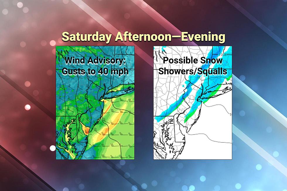
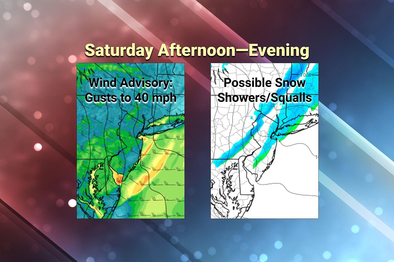
—Timing... We face approximately two lines of precipitation. Initial snow showers may creep into North Jersey around 10 a.m. Saturday. The main event, with the risk of brief snow, is centered around the Saturday early afternoon hours. Anything falling from the sky — squall, shower, or otherwise — should wrap up completely by around 4-5 p.m.
—Totals/Geography... The best chance for a burst of heavy snow will be northern NJ, along and above Interstate 78. We could see a dusting or coating of snow on the ground there. Snow/rain showers/squalls may drift below I-78, perhaps as far south as Ocean-Burlington counties. But that possibility is less certain. I think it's safe to say that South Jersey stays dry and snow-free.
—Impacts... In a worst-case scenario, a snow squall can present two potential hazards. First and foremost is very low visibility. If you drive into a squall visibility could drop to practically zero very quickly. That's not a good situation, especially traveling at highway speed. Second is accumulation. The ground is pretty warm from this week's 60+ degree weather. But heavy snow can overcome that warmth to produce a healthy coating. On untreated surfaces, that can become very slippery. So again, a potential problem for travelers Saturday afternoon.
—Action Steps... You know of the chance of a snow squall, and the risks involved. Stay aware of changing weather conditions from midday into the afternoon. If a "Snow Squall Warning" is issued for your area, you'll want to avoid driving until it passes.
Wind
Once again, the wind impacts won't be as fierce as Friday. (We had a few gusts over 60 mph.) But it will still be a nuisance, blowing around garbage cans, making driving difficult (especially for trucks and vans), and possibly causing sporadic power outages. The wind will blow out of the northwest for the duration. Top gusts look to reach about 40 mph.
Saturday will start calm and fair, before the wind kicks up in the Saturday mid-afternoon to evening time frame. More specifically, I think the wind speed will start to increase to coincide with the start of the snow squall threat — around 11 a.m. And then peak gusts will be after about 3 p.m., as the snow squall (and cold front) finishes its pass through NJ.
Winds should calm late Saturday evening, after about 10 p.m.
A Wind Advisory has been issued for all 21 counties of New Jersey, with some subtle timing differences, depending on county:
—Saturday 10 a.m. to 10 p.m... Sussex and Warren.
—Saturday 1 p.m. to 1 p.m... Atlantic, Burlington, Camden, Cape May, Cumberland, Gloucester, Hunterdon, Mercer, Middlesex, Monmouth, Morris, Ocean, Salem, and Somerset.
—Saturday 1 p.m. to Midnight... Bergen, Essex, Hudson, Passaic, and Union.
Looking Ahead
Sunday will be calmer, but cold. Morning lows will be in the teens across the state. Any residual breeze will push the wind chill ("feels like" temperature) into the single digits. Afternoon highs will be limited to the 30s. It will be sunny and dry.
President's Day Monday still looks like the weather winner of the holiday weekend. We'll keep mostly sunny skies through late afternoon. And high temperatures will push into the mild 50s. Very nice.
A slow-moving storm system on Tuesday will produce an extended period of rain, from morning through night. Nothing heavy, severe, or wintry — just wet.
Wednesday will start warm, probably in the 60s. But colder air will return in the afternoon, sending temperatures tumbling again.
Our next threat of winter weather will come from a complicated storm system setup in the Thursday-Friday time frame. Model guidance shows solutions ranging from heavy snow, to an ice storm, to a sloppy wintry mix. We'll start to dial in the impacts of that potential headache in the coming days.
BEEP BEEP BEEP: These are the 13 types of Wireless Emergency Alerts auto-pushed to your phone
Gallery Credit: Dan Zarrow
The 25 Most Dangerous Cities in New Jersey
Gallery Credit: Matt Ryan
More From WPG Talk Radio 95.5 FM


