Flood Watch for NJ: Heavy rain and wind to disrupt weekend plans
The Bottom Line
Friday will be dry. Sunday, Monday, and Tuesday too.
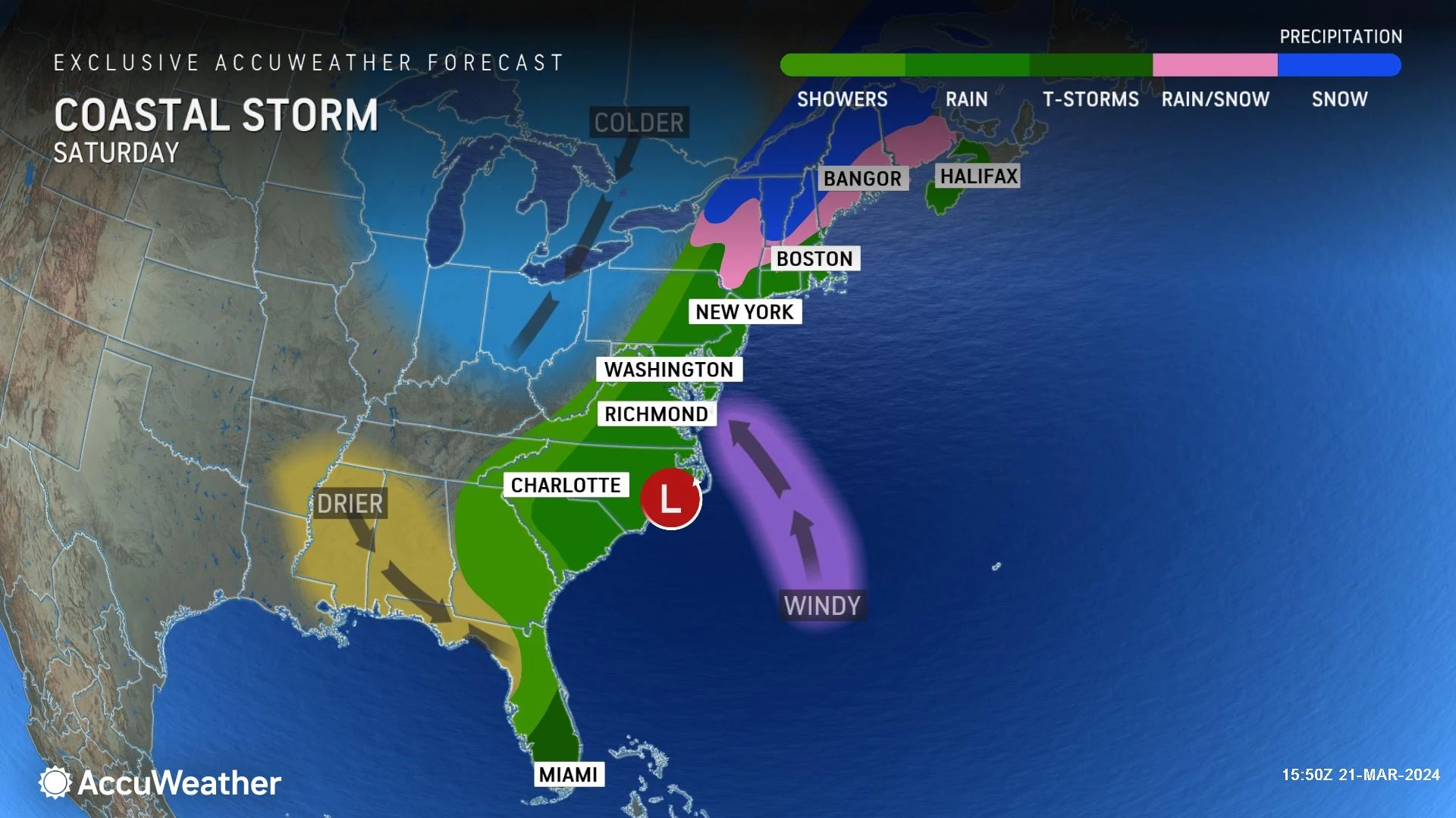
But Saturday is going to be a nasty, inclement weather day for New Jersey, as a potent coastal storm swings in. By the numbers, 2 to 3 inches of rain, 40 mph wind gusts, and localized minor coastal flooding are on the table. Raising concerns for flooding and travel difficulties.
Many outdoor events are already activating their backup plans and rain dates, and with good reason. I do not see much hope for any pockets of substantially dry weather between sunrise and sunset on Saturday.

Friday
It is a cold and dry start to Friday, which will have you reaching for the coat and Chap Stick. Temperatures have fallen into the 20s for the vast majority of New Jersey. The only spot starting the day above freezing is the Jersey Shore.
You will want the sunglasses early on Friday too, as sunshine dominates through the morning. By mid-afternoon, clouds will start to roll in.
High temperatures on Friday will reach the mid 40s or so. Still on the cool side of normal. But at least the wind will be much lighter and more comfortable, compared to Thursday.

As skies become cloudy Friday evening, rain should hold off until Midnight or later. That will be the start of 18 to 24 hours of wet, stormy weather.
Saturday
Wet, wet, wet. And windy too.
Is there any hope of substantial periods of dry weather on Saturday? Not really. I am calling it a washout, with moderate to heavy rain from sunrise to sunset.
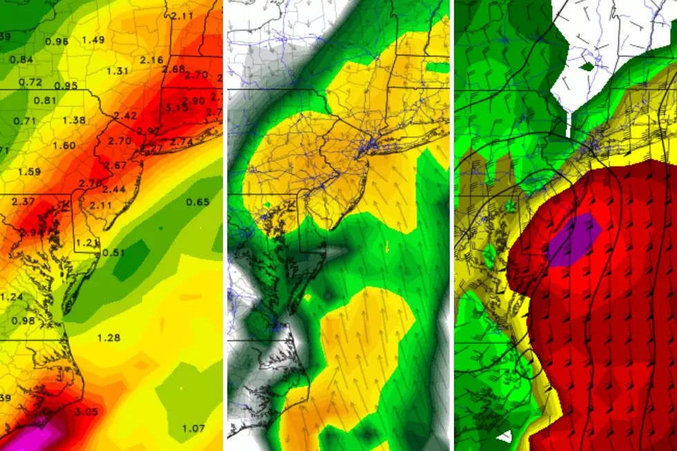
Total rainfall will likely reach about 2 to 3 inches for most of New Jersey. If a corner of the state misses all heavy rain bands, it may end up close to an inch. Meanwhile, a real downpour could push totals closer to 4 inches.
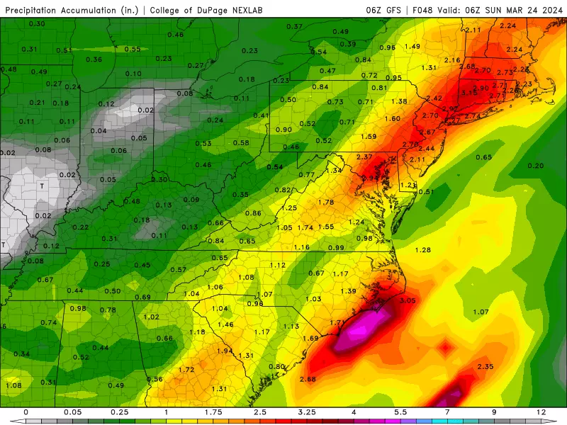
I do not want to get specific about the geography — who is going to see the most rainfall — since the axis of wettest weather changes with every model run. Bottom line: No matter where you are, a lot of water will be falling from the sky Saturday.
Saturday could become the wettest calendar day of 2024 so far. And that is significant, since we have had some real soakers this winter.

A Flood Watch has been issued for the entire state of New Jersey, in effect from early Saturday morning through early Sunday morning. Flooding and ponding — i.e. big puddles — may necessitate road closures.

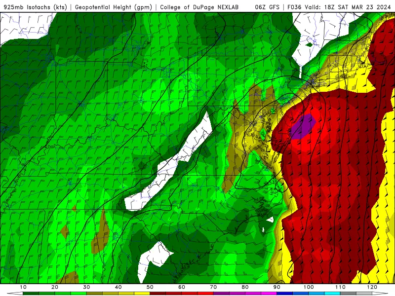
In addition, wind gusts may exceed 40 mph at times. Rumbles of thunder are possible too. The coastal flooding picture looks better, but I could see localized minor category flooding issues, especially late Saturday into Sunday. The chance of wintry weather is still practically zero — this is a wind and rain machine.
As rain exits the Garden State early Saturday evening, around dinnertime, skies should clear quickly. While a light freeze is possible by Sunday morning, icing seems unlikely.
Sunday
That coastal storm system will still be spinning over the Atlantic Ocean, potentially keeping lingering clouds over the Jersey Shore. Farther inland, Sunday should turn bright and sunny.
It will be breezy and dry Sunday, with high temperatures on either side of 50 degrees.
Monday
Monday's forecast looks quite pleasant, with sunshine, dry weather, and seasonable-to-mild high temperatures pushing into the mid 50s.
The Extended Forecast
Tuesday stays quiet, with increasing clouds and highs in the 50s.
Our next storm system will be a cold front, forecast to deliver showers and clouds on Wednesday.
Still no significant warmup in sight, through the end of March. No wintry weather either. Just status quo, near-normal weather punctuated by occasional rounds of rain.
BEEP BEEP BEEP: These are the 13 types of Wireless Emergency Alerts auto-pushed to your phone
Gallery Credit: Dan Zarrow
Dan Zarrow is Chief Meteorologist for Townsquare Media New Jersey. Follow him on Facebook for the latest forecast and realtime weather updates.
2024 St. Patrick's Day Parades in NJ (by date)
Gallery Credit: Dan Alexander
More From WPG Talk Radio 95.5 FM


![New Atlantic City Casino Beach Club Set To Open — Food, Bar [Photos]](https://townsquare.media/site/564/files/2026/06/attachment-img_2853-18.jpeg?w=980&q=75)
