
Late Week Nor’easter Impacts for NJ: 1-2″ Rain, Snow Northwest
UPDATE... This article is outdated...
For the latest winter storm forecast information, please refer to my newest weather blog post.
The Bottom Line
There are two prominent weather stories emerging for this week. First, a cold, dry air mass will keep our weather quiet and temperatures chilly for Tuesday and Wednesday. And then a nor'easter (coastal storm) will drive in sloppy, mainly wet, somewhat wintry weather for Thursday into Friday.
We are getting a clearer picture of how that late-week storm will play out. Your executive summary:
1.) Thursday and Friday are going to be sloppy, inclement weather days, no matter where in the state you are.
2.) Most of New Jersey should see rain only, on the order of 1 to 2 inches total.
3.) There could be a quick hit of icy mix as precipitation begins Thursday morning.
4.) Yes, accumulating snow looks likely to the northwest. Maybe heavy snowfall, on the order of 6+ inches.
5.) Wind (30-40 mph) and coastal flooding are also concerns.
Let's dive into the forecast in a little more detail now, focusing mainly on the timeline.
Tuesday
The only weather issue for Tuesday will be the unseasonably chill in the air.
Everybody in New Jersey froze overnight. As of this writing (6 a.m.), temperatures across New Jersey range from 13 to 29 degrees. Brrr — bundle up!

High temperatures will only reach the lower 40s Tuesday afternoon. Not terrible, especially with light winds. But it's about 5 to 10 degrees below where we would like to be here in mid-December. Skies will stay sunny, and weather will stay dry.
Tuesday night, a reinforcing shot of cool air could kick up a little breeze by daybreak. As low temperatures descend into the mid 20s, the wind chill ("feels like" or "apparent" temperature) could dip into the teens. Another cold one.
Wednesday
Quiet and dry. Although also still cold, with some noticeable changes.
Wednesday will start with sunshine. Then clouds will increase through the afternoon. No rain yet. High temperatures will only hit about 40 degrees.
Thursday-Friday
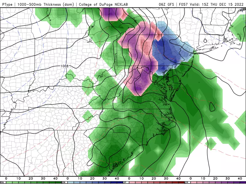
—Start... First band of precipitation will push into SW NJ Thursday morning, spreading throughout the state by midday. Light to moderate stuff during the day.
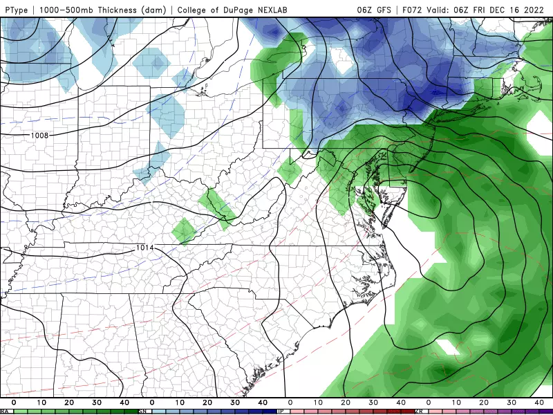
—Brunt... Thursday evening, heavier bands will drive in from the west. Thursday night through early Friday morning will feature the heaviest precipitation and highest winds of the storm.
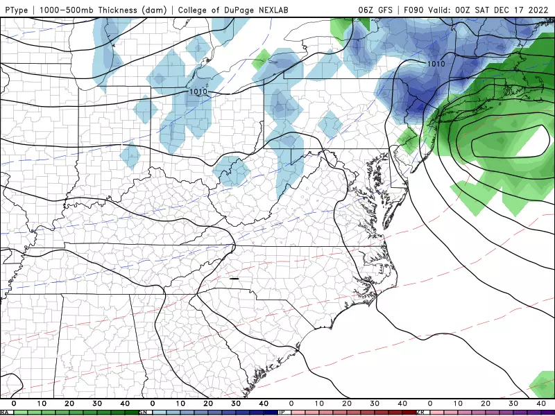
—End... Snow, rain, and wind will slowly dial back on Friday. Final drops and flakes will probably fall around late afternoon, with clearing skies into Friday night.
—Concern #1... Icy mix. If the onset of precipitation Thursday morning comes early enough, temperatures may be cold enough for some snow/sleet to mix with the rain. We will have to watch that early AM commute period very carefully, especially to the south and west.
—Concern #2... Snow. Although most of New Jersey is facing a very wet forecast, there is a good chance northwestern New Jersey will stay cold enough to sustain snow for the duration. Heavy/major snow is a possibility, if temperatures stay cold enough and there is no mixing.
—Concern #3... Wind and coastal flooding.
—Rainfall Totals... 1 to 2 inches of rain seems like a solid bet for most of the state. The mesoscale NAM model is pumping out serious downpours Thursday night, amounting to 3 to 4 inches around southern New Jersey. However, I'm not sure the atmosphere will tap into enough moisture to fuel such heavy rain.
—Snowfall Totals... The northwest corner of the state (only) is facing snow accumulation. That is the area north of Interstate 78 and west of Interstate 287. Most models suggest 2 to 4 inches, in a scenario where rain mixes in with snow for a time. But if this forecast trends colder, and precipitation remains snow for the entire storm (or at least for the heavy stuff Thursday night), I could see 6+ and even 10+ inch totals. I am not going to be the one to broadcast a literal snow forecast of "0 to 18 inches" this time around — stay tuned, as we hopefully will have a better handle on this soon.
—Top Wind Gusts... 30 mph inland, 40 mph coast. Potentially bringing down branches, causing sporadic power outages, and reducing visibility even more.
—Coastal Flooding... Initial tidal guidance shows a foot or two of surge, causing widespread minor category flooding along NJ's tidal waterways. It would last for one or two high tide cycles, likely peaking during the brunt of the storm Thursday night. (High tide is around Midnight.)
—Final Thoughts... Thursday and Friday are going to be sloppy, inclement weather days, no matter where in the state you are. Mainly rain, somewhat wintry, with some wind and coastal flooding thrown in too.
The Extended Froecast
Our weather quiets down and cools down again for the final weekend before Christmas. I'm seeing a mix of sun and clouds and 40s for Saturday, descending to about the 40 degree mark on Sunday. Our next chance of a storm system would be the middle of next week.
30 unique 'experience' gifts New Jerseyans actually want to get
Gallery Credit: Dan Zarrow
Light Up New Jersey: Best holiday displays of 2022
Gallery Credit: Light Up NJ — Vote here
More From WPG Talk Radio 95.5 FM


