
Lousy March Weather for NJ: Goodbye 70s; Hello Snow, Sleet, Rain
The Bottom Line
70s on Monday. Snow on Wednesday. Within just 36 hours! We're in the midst of a wild transition of flip-flopping seasons here. And that will lead to a tranquil weather day for Tuesday. But of course, we are looking at both wintry and wet weather impacts on Wednesday.
That will be the first of two storm systems worth watching through the rest of the week. The next one, on Saturday, looks even stronger and more impactful.

Tuesday
Back to blustery. Temperatures have cooled into the 40s for Tuesday morning. It's not that cold — we are well above freezing, after all. But the wind is still elevated, occasionally gusting as high as 30 mph through the morning hours. That wind will calm down considerably by this afternoon.
Aside from the wind, it will be a tranquil and reasonably pleasant early March day. High temperatures will reach the upper 40s in the afternoon — right on the normal high for this time of year. Look for breaks of sun early, then cloudier conditions through the afternoon.
Clouds will continue to thicken up Tuesday evening. And we could see some light snow creep in after Midnight. Low temperatures will end up in the lower to mid 30s by Wednesday morning.
Wednesday
Here comes our next storm system. And it looks both wintry and wet for New Jersey.
As an area of low pressure tracks along a stalled frontal boundary south of New Jersey, we'll see precipitation become steady right around daybreak Wednesday. "Stuff" will be falling from the sky for most of the daytime hours. Precipitation should start to taper in the afternoon, ending completely right around sunset.
Now let's talk about exactly what will fall from the sky. In a nutshell, a little bit of everything — snow, sleet, and rain.
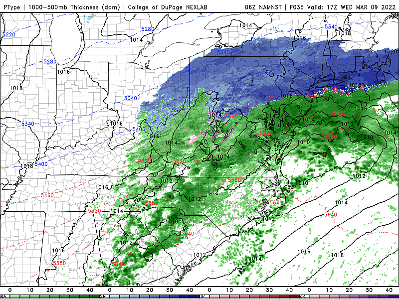
Some forecast models (looking at you, NAM) are pumping out some heavy snowfall, cold temperatures, and healthy snowfall. (Upwards of 9 inches in NE NJ.) But I don't buy it. There are way more limiting factors than indications we are going to get buried:
—Our recent warm stretch has warmed up the ground. Soil temperatures are now in the 40s, which will make it very hard to get snow to stick.
—Near-surface air temperatures will be dubious, primarily above the freezing mark for the duration of the event.
—Farther aloft, there are suggestions of warming up in the atmosphere as the storm passes by, leading to more of a sleety than snowy scenario.
—Ocean temperatures have risen into the mid 40s, insulating the NJ coast. If it's hard getting an "all snow" situation along the Shore in the dead of winter, it's exponentially more difficult now.
—Because of those temperatures at or above freezing, the moisture content of the snow will be low. So it will be heavy, wet snow — which does not accumulate as high as dry, powdery snow.
It's just not a slam dunk. So I think we can play this storm out very casually. I expect little to no accumulation. Travel headaches should be minimal. But weather conditions will be inclement — wintry and wet — no matter where in the state you are.
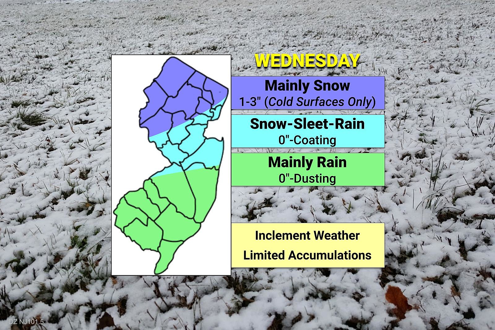
Let's break the state into three forecast regions, conveniently using the interstate highway system as dividing lines.
—North of Interstate 78... Mainly snow. But that wet snow is going to have a hard time sticking to (relatively warm) pavement. While 1 to 3 inches of accumulation is possible, it would be limited to colder surfaces like grass, roofs, cars, etc.
—Between I-78 and I-195... We'll probably flip-flop among snow, sleet, and rain. If it snows hard enough, a coating is possible. (On those same colder surfaces I just mentioned.) There could be slippery spots, but this is not a major storm.
—South of Interstate 195... Mainly rain. There could be some snow and sleet, especially early and late on Wednesday. But expect weather to lean much more on the "wet" side than "wintry".
No watches, warnings, or advisories have been issued for New Jersey for this storm. (Although a couple of PA Poconos counties fall under a Winter Weather Advisory.) We'll keep you posted if that changes. No wind or coastal flooding threats either.
Thursday & Friday
Flipping back to relatively pleasant weather.
I see no problems with Thursday's forecast. We'll progress from clouds to sun, with high temperatures close to 50 degrees.
Friday's temperatures will have a bit more variation. An on-shore (easterly) wind will keep shore points cool. But abundant sunshine will push inland temperatures warmer. So we'll still average 50 degrees statewide — but that's really "mid 40s coast, mid 50s inland".
We are still watching a coastal storm system that currently looks like a near-miss for New Jersey in this time frame. I wouldn't rule out an isolated rain shower late Friday. But at this point, it largely looks like a non-issue.
Saturday
Our next storm system. And this one could be another wild ride.
Saturday will start warm, with temperatures bumping as high as 60 degrees. Then a cold front will sweep in a batch of soaking rain. Then colder air potentially forces a transition to subfreezing temperatures and snow.
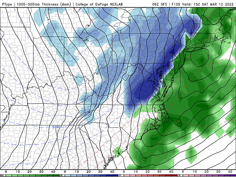
Cold fronts are notorious for not producing heavy snowfall here in New Jersey. But this one is worth watching, for the potential of at least some snow and ice. In addition, we have to talk about the return of ferocious winds, probably gusting over 40 mph both before and after the frontal passage.
It's still too early to talk about accumulations. If this thing still looks wintry, we'll talk more details on Thursday. (One storm at a time, please.)
We'll close out the weekend with a cold and blustery day Sunday. Teens in the morning, 30s in the afternoon. It will be a sunny, but bitter day.
Temperatures should moderate into the 50s for Monday. The final full week of winter looks relatively quiet, although snow season isn't quite over yet.
The Blizzard of '96 Revisited: Snow totals for every NJ county
Gallery Credit: Joe Votruba
2022 Seaside Heights Polar Bear Plunge photos
Gallery Credit: Andrew Miller/For Townsquare Media NJ
More From WPG Talk Radio 95.5 FM


