NJ Weather: 3 Spring-like Days in the 60s With Some Rain
(College of DuPage Meteorology)
The Bottom Line
According to my math, temperatures on Wednesday will run 19 degrees above normal for the middle of February. Wow. Lower to mid 60s would be typical in mid to late April. Not February.
Record highs are probably safe though. In case you are playing along at home, on the 15th of February in 1949, temperatures reached the 70s across NJ.
The next three days will be unusually warm but also increasingly unsettled. A storm system will deliver a few spurts of rain, followed by a big blustery cooldown.
By the start of the weekend, it will (temporarily) feel like seasonably chilly February weather.

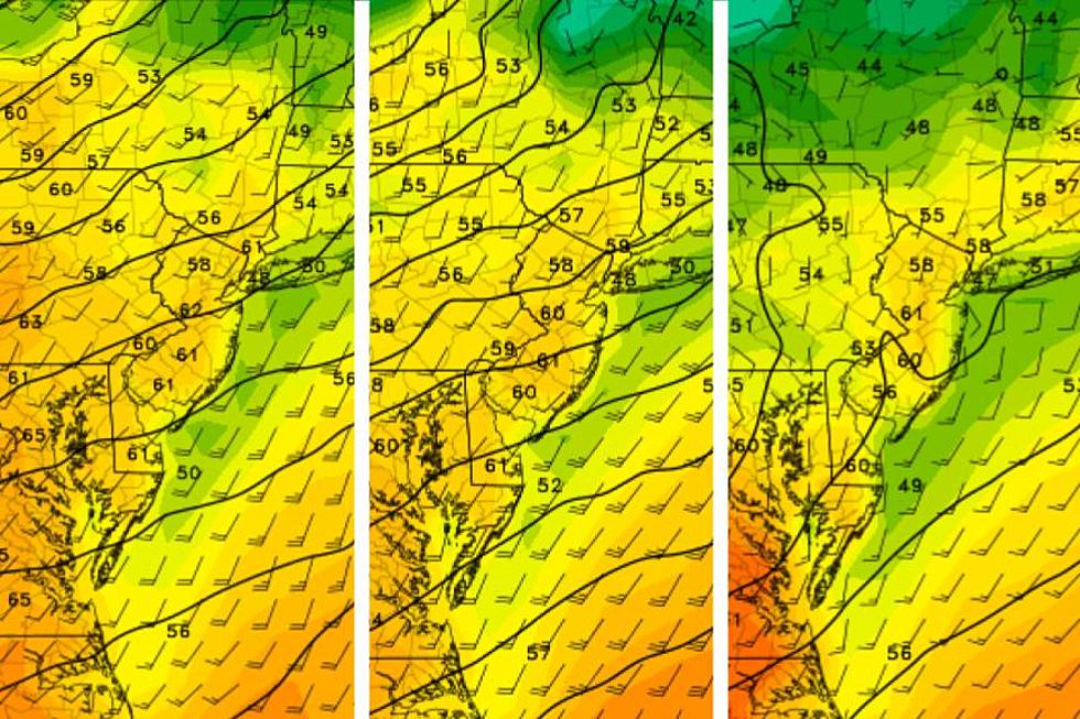
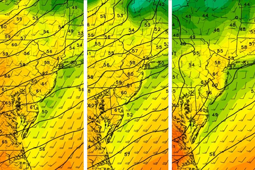
Wednesday
I suspect Wednesday will be the warmest or 2nd warmest day of 2023 so far, as a southerly wind carries in warmer, more humid air.
We are starting the day with some raindrops. A batch of light showers will push from west to east around late morning. However, our air is still pretty dry — so far most showers have fizzled and evaporated before even reaching the ground. So don't expect much more than a brief period of dreary, potentially damp weather.
By late morning, we will be dry. And skies will clear through the afternoon. I'm not sure if we'll go all the way to "mostly sunny" or stop at "partly sunny". But we will enjoy a bright second half of the day.
(College of DuPage Meteorology)
And it will be warm. My forecast calls for high temperatures between about 58 and 67 degrees, north to south. I doubt you'll need a jacket later on. The only weather nuisance will be a stiff breeze, gusting over 20 mph.
Wednesday night will not be cold. Low temperatures around 50 degrees are warmer than the normal high temperature for this time of year. The overnight will be partly cloudy and dry.
Thursday
A broad storm system will approach on Thursday, sparking severe weather concerns from the Gulf of Mexico to the Great Lakes. Here in New Jersey, we are facing approximately two spurts of rain in the Thursday-Friday time frame. Total rainfall will likely end up between a half-inch and an inch. Healthy, but not necessarily heavy.
The first batch of scattered rain will bubble up from the southwest around late morning on Thursday, potentially lingering through dinnertime. So yes, you'll probably get wet.
But at least it will still be warm. Despite the clouds and the raindrops, thermometers should still touch about 60 to 65 degrees across most of the state.
Model consensus shows an overall lull in rainfall activity Thursday night. Having said that, there could still be some showers around. Temperatures will stay warm, in the 50s and 60s, right through Friday morning.
Friday
Another big transition day — which we have seen so many of recently. Friday morning's weather will be drastically different from conditions by Friday afternoon.
The day will begin with one final push of rain. Again, temperatures will be way above freezing, so there is zero snow potential in the forecast here. Final raindrops should come by late morning. And that's about the arrival time of our cold front — the leading edge of cooler, drier air.
As a gusty northwest wind kicks up to 30+ mph, temperatures will take a tumble. While Friday morning will be in the 60s, thermometers will drop deep into the 40s by late afternoon.
With a clear sky and (eventually) calmer winds, Friday night will be even colder. We should see widespread 20s — a hard freeze — envelop NJ by Saturday morning.
Saturday
A seasonably chilly February day. In fact, the only seasonable day in the forecast.
With sunshine and a light breeze, high temperatures will be limited to about 40 to 45 degrees. Right on the long-term averages for mid to late February. Not a bad day, if you don't mind the renewed chill in the air.
Sunday & Beyond
And that concludes New Jersey's upcoming cold snap. On Sunday, a flip to southwesterly winds will help temperatures return to the mild lower 50s. Clouds may overtake the sun for part of the day. But I do predict a completely dry weekend.
Monday is President's Day. And temperatures will remain well above normal, in the 50s. However, the GFS model in particular shows a weak wave firing off some rain showers in the afternoon hours.
Tuesday looks mostly cloudy and slightly cooler, near 50.
And then our attention turns to a potentially big weather maker centered around Wednesday. This one looks interesting — meaning the storm track and forecasted temperatures could be conducive to producing accumulating snow.
However, you know the 6 and 7 day forecasts have been horrendous this winter. Every time a potentially snowy scenario pops up in the long-range forecast, it completely fizzles. So let's definitely not hold our breath or count our chickens here. If next week's storm system turns into something, you'll be among the first to know.
The 25 Most Popular Last Names in New Jersey
Gallery Credit: Matt Ryan
HA! These out-of-state driver comments on using NJ jughandles are pure gold
Gallery Credit: Mike Brant
More From WPG Talk Radio 95.5 FM


