NJ weather: A few showers Friday, cooler but pleasant weekend
The Bottom Line
All good things must come to an end, unfortunately. This week of warm weather has brought temperatures as warm as 79 degrees on Thursday. It was a wonderfully welcome change of pace from the active, wet weather throughout the first third of March.
A slow-moving cold front will drive New Jersey's weather on Friday. There will be a few rain showers around — although last-minute weather models have really backed off on rainfall estimates. Temperatures will start to dial back too — however, this will not be a sudden "arctic blast" kind of cooldown.
The final weekend of winter will be cooler. But temperatures will still reach above seasonal normals, with generally pleasant weather. The only hiccup will be an isolated shower in North Jersey on Sunday morning.
Next week turns rather February-ish. Expect a chilly transition from Winter to Spring. (The Vernal Equinox is Tuesday night.)

Friday
There is no real danger to "beware" on this Ides of March.
It will be unsettled and still warm. We have seen some hit-or-miss showers and sprinkles around New Jersey early on this Friday morning. And that is pretty much the story of the day. Spotty raindrops, mostly cloudy skies, and an occasional breeze.
If I had to guess, the best chance for showers will be around the late afternoon hours, around central and southern NJ. Total rainfall will only amount to a few hundredths of an inch.
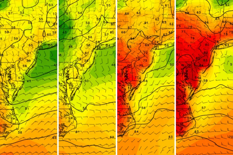
Meanwhile, temperatures Friday morning are in the 50s. That is warmer than our normal high temperature in mid-March. High temps will range from the mid 60s in North Jersey, to the lower 70s in South Jersey. Yes, we have the potential for one more 70-degree day!
Starting Friday afternoon, thermometers will likely start to fall. Again, it won't be a rapid cooldown. But probably noticeable, as we slide back into "jacket weather".
As the shower chance ends and skies start to clear Friday evening, it will get pretty cool overnight. Low temperatures will dip into the lower 40s by Saturday morning. The chance of a widespread freeze is very low.
Saturday
Definitely cooler, as we miss the 70-degree mark. But still quite pleasant.
I'm going to call Saturday a partly sunny day. But realistically, sunshine will dominate, maing for a nice, bright sky. Winds will be light. And our weather will stay dry.
High temperatures Saturday afternoon will end up around 55 to 60 degrees. 10 to 15 degrees cooler than Friday. But still 5 to 10 degrees above normal for mid-March.
Sunday
Sunday is St. Patrick's Day. And the weather will almost totally cooperate with your plans.
The only hiccup of the entire weekend will be a rain shower potentially clipping North Jersey Sunday morning. Between about 4 a.m. and 8 a.m. Just a quick hit of light rain to the north. Then the rest of the day will be fine.
Sunday will turn breezy again, with wind gusts possibly topping 20 mph. High temperatures will come close to 60 degrees, with a nice mix of sun and clouds.
Monday
Monday will suffer from a reinforcing shot of cool air, keeping the breeze elevated and sending temperatures to the chilly side.
My latest forecast puts high temps on Monday only in the upper 40s. Maybe 50 degrees. That is just below normal for this time of year. We will see lots of clouds overhead Monday. And I can not rule out an isolated snow shower at some point too. No accumulation or travel impacts though.
Tuesday & Beyond
Tuesday is the first day of Spring. And the new season will begin with ... unseasonably chilly temperatures.
Both Tuesday and Wednesday will be 5 to 10 degrees below normal, with highs only reaching the mid 40s or so. Feeling like February.
Temperatures will hopefully moderate into the seasonable 50s for the second half of next week. Our next threat of a significant storm system will be late next week, heading into the first weekend of Spring.
New Jersey's St. Patrick's Day Parades 2024 (by date)
Gallery Credit: Dan Alexander
Dan Zarrow is Chief Meteorologist for Townsquare Media New Jersey. Follow him on Facebook for the latest forecast and realtime weather updates.
Best Irish bars in New Jersey, as picked by Big Joe Henry
Gallery Credit: Big Joe Henry
More From WPG Talk Radio 95.5 FM


