
NJ weather: Another steamy, stormy start to the workweek
The Bottom Line
This weekend was a mixed bag of weather — somewhat stormy Saturday, beautiful and warm Sunday. On balance, we did well. And we have more pleasant weather to talk about, but not until the second half of this workweek.
In the meantime, the big weather story here is New Jersey's fourth shot at strong thunderstorms in just eight days. Monday night could get pretty nasty again, with heavy rain, gusty winds, and an electric atmosphere. The air is going to be quite "juicy," as humidity levels rise to "tropical" uncomfortably high levels.
Once we get past unsettled weather from Monday night to Tuesday, things should calm down a bit. The cold front that spawned the thunderstorms will stall just southeast of NJ, which will keep humidity levels up and skies a bit murky. Once another frontal boundary passes on New Jersey, we will taste deliciously dry air once again. Possibly just in time for next weekend?

Monday
For the most part, Monday's daytime hours will be fine. The trouble comes Monday night.
We are starting the day with par-for-the-course temperatures, mainly in the 60s. And by the numbers, Monday will be similar to Sunday, with highs around 85 to 90 degrees. Dew points in the 60s will add a sticky feeling to the air.
Skies will be mostly cloudy throughout Monday. And I can't rule out a popup shower in the afternoon, as a warm front rises from the south.
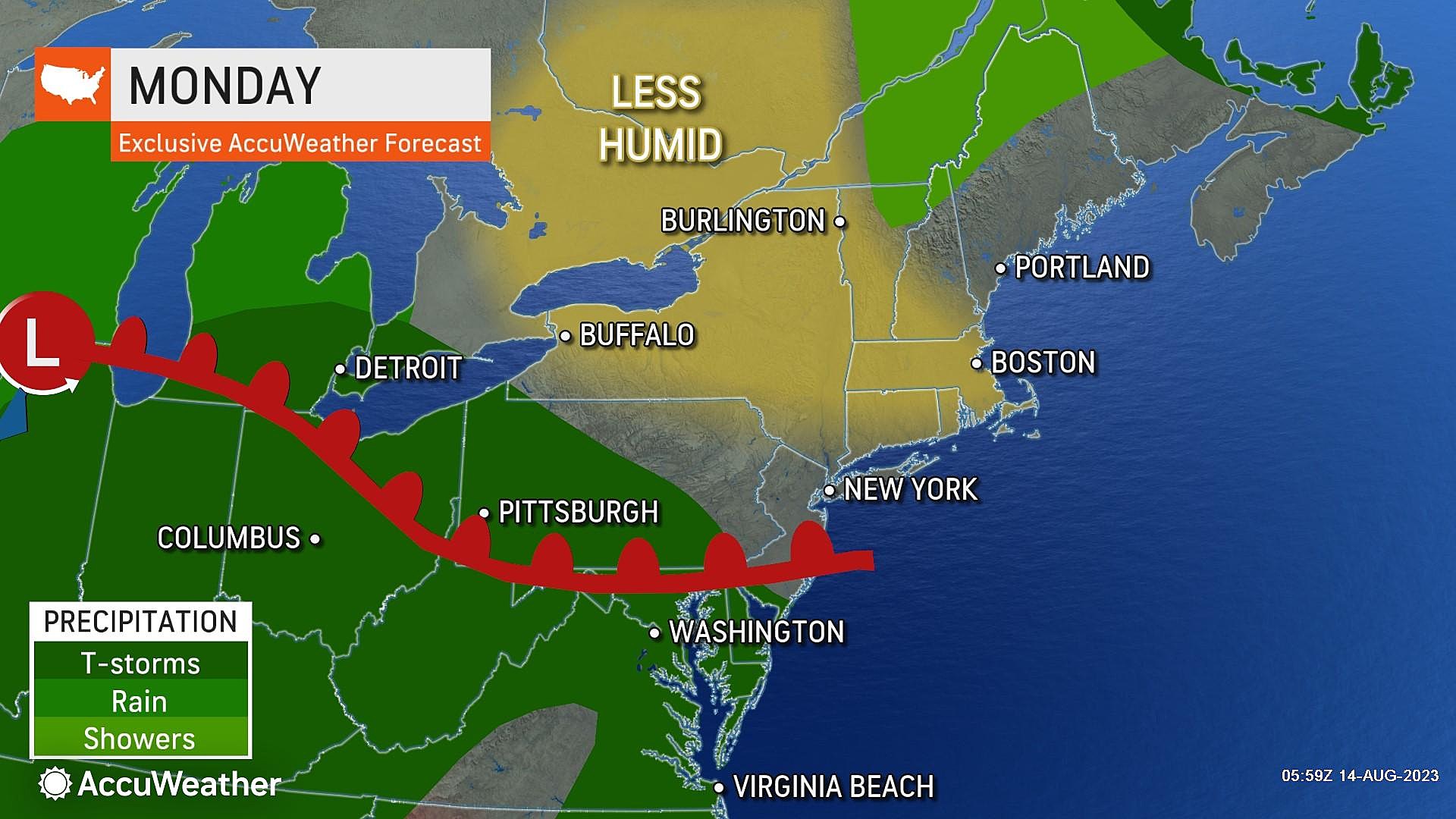
The main event — scattered strong thunderstorms — will creep into New Jersey as early as 6 or 7 p.m. Stormy weather may continue through the early morning hours of Tuesday, ending by about 4 or 5 a.m.

I am very worried about downpours and areas of flooding, given the incredibly humid atmosphere Monday night. Severe weather — gusty winds, small hail, and a tornado — is also a possibility. So yes, there is a good chance of nasty weather where you are Monday night — hopefully you can tuck yourself inside a sturdy building for the duration.

Overnight low temperatures will only drop into the 70s. It is going to be crazy muggy.

Tuesday
By sunrise Tuesday morning, the big batch of thunderstorms will have subsided. But we still have a cold front to pass during the day on Tuesday.
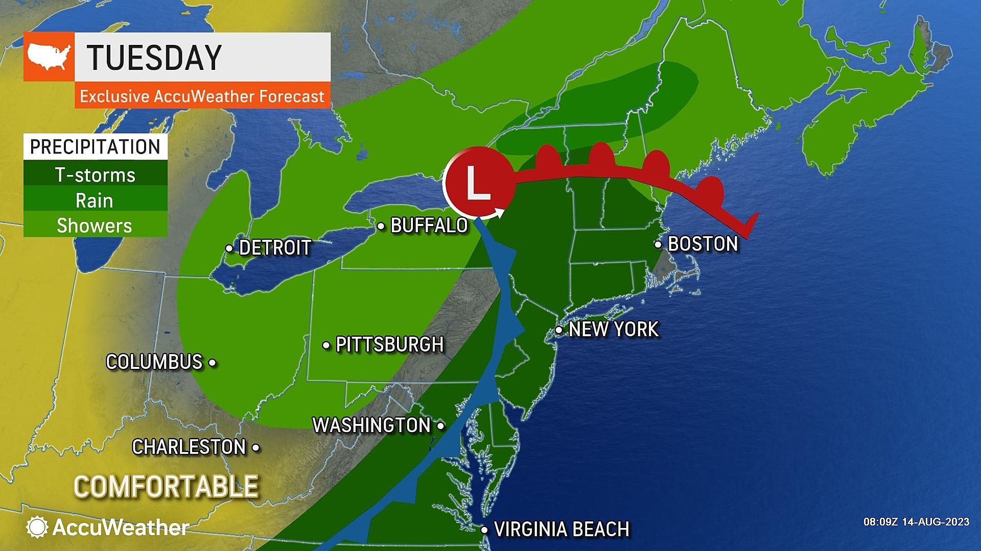
So I have to leave a few showers and thunderstorms in the forecast throughout the daytime hours on Tuesday. The best chance for raindrops will be late-day, in the afternoon and evening hours. Severe weather is possible, but the threat seems lower than Monday night.
Alongside potential storms, we will see breaks of sun throughout Tuesday. High temperatures will once again reach the mid to upper 80s across most of NJ.
We will tap into slightly less humid air as Tuesday goes along. I am optimistic temperatures will dip into the 60s Tuesday night, which is seasonably, reasonably comfortable.
Wednesday
The aforementioned cold front is forecast to stall just southeast of New Jersey. It will be close enough to keep some clouds and humidity in place. However, the latest guidance does keep our weather dry for Wednesday. (And Thursday too.)
So we can hopefully celebrate a storm-free day on Wednesday, with partly sunny skies. High temperatures will be close to seasonal averages, in the lower to mid 80s.
Thursday
Very similar to Wednesday. Although with more clouds. And a more prominent southeasterly (on-shore) breeze, keeping the coast cooler.
More high temps will again hit lower to mid 80s Thursday afternoon.
Friday & Beyond
The final cold front of the week is set to arrive Friday morning. While there could be some shower and thunderstorm activity to watch, the speed of the front will hopefully limit any dangerous weather. Behind that front, dew points will drop like a stone, ushering in much drier, more comfortable air.
So if all goes well, and this forecast plays out as I think it will, we could be treated to a dropdead gorgeous next weekend. Of course, it's still only Monday. But you know we'll be watching that weekend outlook closely!
A tornado's rapidly approaching - what should you do?
Gallery Credit: Sophia Laico
Dan Zarrow is Chief Meteorologist for Townsquare Media New Jersey. Follow him on Facebook or Twitter for the latest forecast and realtime weather updates.
BEEP BEEP BEEP: These are the 13 types of Wireless Emergency Alerts auto-pushed to your phone
Gallery Credit: Dan Zarrow
More From WPG Talk Radio 95.5 FM


