
NJ Weather: Don’t Be Surprised By Rain or Wintry Mix Monday Night
The Bottom Line
A new workweek begins! And with exactly two weeks to go until the official start of Spring, time is very limited to get any sort of substantial winter storm this week.
There is only one shot of inclement weather in the forecast, arriving Monday night. This storm system is compact and will be fast-moving. However, models have been trending colder (and therefore snowier) and heavier, with a piece of stronger lift coming into play. So it is worth raising an eyebrow to the possibility of "conversational" snow/ice accumulations. And also the possibility of tricky travel conditions for a time.
Beyond that overnight taste of wintry weather, the rest of this workweek will be quiet. Next storm system worth watching for wet/wintry potential arrives next weekend.

Monday
The daytime hours look good, as we enjoy another pleasant early March day. Clear skies and light winds are yielding mainly 30s to start the day. Highs will reach the mid 50s across most of New Jersey Monday afternoon. High clouds will slowly build in during the afternoon hours.
It will be about a 95% dry day. Guidance hints a little sprinkle or flurry may clip northern New Jersey around midday.
Our next storm system will roll in after sunset on Monday. Precipitation should begin between about 7 and 10 PM to the northeast, reaching southern and coastal NJ sometime after midnight.
For a few hours, a period of snow (north), wintry mix (central-south), and rain (south) are likely. Intensity could climb to moderate or even heavy. That raises alarm bells for reduced visibility and slippery road conditions.
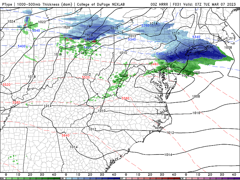
We could conceivably pick up an inch or two of snow/ice accumulation. It is difficult to pinpoint exactly where that will happen — especially since temperatures will be within a couple degrees of the freezing mark. I suspect the best chance for light accumulations will be along and just south of the Interstate 78 corridor. Maybe down to I-195, if it is cold enough. (Based on the trajectory of this storm system, I do not think far northern New Jersey — Sussex County — will be the snowfall bullseye this time around.)
I was shocked by the NAM model's suggestion of 5 or 6 inches of snow along a tight band near that geography. The NAM is a mesoscale (medium-scale) model, that can be remarkably good at picking up on heavy snow band potential. So it's worth keeping that chance in the back of our minds — although I suspect dry air and warm ground will keep totals much lower.
No advisories, watches, or warnings are in effect for New Jersey, as of this writing (7 a.m.)
South of I-195, we'll likely see a wintry mix of snow and rain. South of the Atlantic City Expressway, I doubt it will be anything other than wet.
Precipitation should wrap up by daybreak Tuesday, just in time for the morning commute. That means we will only have to deal with what's on the ground, not anything falling. Temperatures will bottom out around the lower to mid 30s, with colder 20s in NW NJ.
Tuesday
Despite the wintry and wet start, Tuesday begins a stretch of dormant weather.
Having said that, Tuesday is going to turn breezy, if not windy. Through the afternoon, top wind gusts may hit 30+ mph. That whoosh of cold air will keep temperatures below seasonal normals. We'll see lower to mid 40s Tuesday afternoon.
Wednesday
Wednesday will look very similar to Tuesday, but with less wind. Expect mostly sunny skies and highs again around 40 to 45 degrees. (Keep in mind, normal for early March is around 50.)
Thursday
More sunshine, and a return to seasonable temperatures. You can't ask for much more than that in turbulent, violent, lion-ish March. Look for highs around 45 to 50 degrees. Again, light winds and dry weather.
The Extended Forecast
Clouds will increase on Friday, but temperatures should still flirt with 50 degrees.
Our next storm system will come into play over the weekend. I think forecast models are still struggling over timing and precipitation type. At the moment, Saturday morning looks to be prime for a period of snow (north/west) and rain (south/east). The northern edge of the state could again see some accumulating snow/ice. So again, it is worth watching.
Long-range models show another storm system around next Monday. It could be the beginning of an active final week of winter.
Let it snow: 12 things to know about winter forecasting in NJ
Gallery Credit: Dan Zarrow
12 Things You Should NEVER Recycle
Gallery Credit: Boris
More From WPG Talk Radio 95.5 FM


