
NJ Weather: Heavy Rain from Barry Remnants then Ferocious Heat
As this post's headline suggests, there are two very important weather headlines for this week — and I don't want either one to get lost in the shuffle. 1.) As the remnants of once-Hurricane Barry approach New Jersey, we'll feel an uptick in humidity and a chance for very heavy rain. 2.) Ferocious heat and humidity arrive just in time for the weekend.
Either situation could become downright dangerous, so let's jump into the forecast.
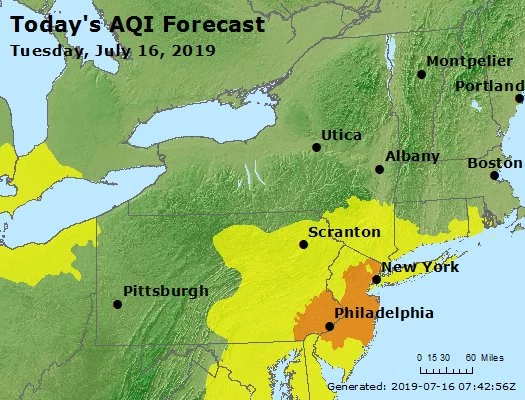
Our dreaded summertime nemesis humidity returns to the atmosphere Tuesday. We're actually comfortable Tuesday morning, with most temperatures in the 60s. But as dew points pop into the 70s Tuesday afternoon, it's going to be noticeably stickier. Skies will be partly sunny. High temps range from the lower-mid 80s at the beaches to near 90 for most of inland NJ.
An Air Quality Alert has been posted by the NJ Department of Environmental Protection and the National Weather Service for a good swath of New Jersey. It's our typical Code Orange day, which means sensitive groups should stay in air conditioning as much as possible. This includes the very young, the very old, and those with heart/lung issues.
There will be a chance for a gusty shower or thunderstorm Tuesday evening (after about 6 p.m.) as a batch of fizzling rain approaches from the west. Best chance for rain will be along the western edge of New Jersey. But I'm not convinced this convection will hold together all the way to the coast.
It is going to be muggy and warm Tuesday night. Low temperatures will only fall into the lower to mid 70s. Get used to not falling below 70 degrees — that will be the story for the next week or so.
Clouds will increase Wednesday, with a stiff southwesterly breeze. It is definitely going to be hot and definitely humid. Thermometers should push into the lower 90s away from the coast. The heat index ("feels like" temperature) will likely be in the mid to upper 90s during the hottest part of the day.
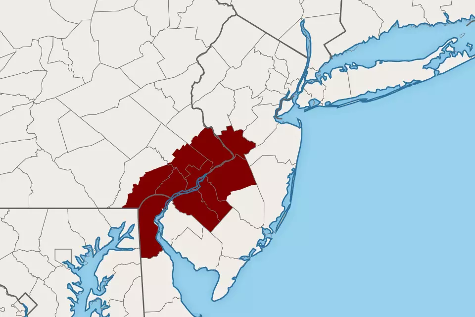
An Excessive Heat Watch has been issued for the Philadelphia metro area (NW Burlington, Camden, Gloucester, and Mercer counties. The watch is in effect from 8 a.m. Wednesday through 10 p.m. Sunday. Yes, five consecutive days. (More on the extreme heat wave in a second.)
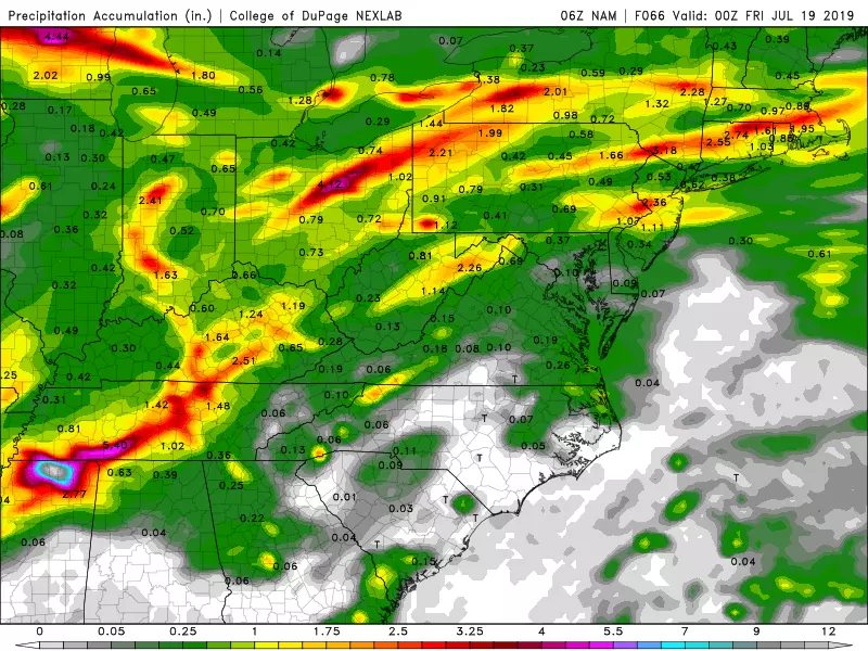
The remnants of Barry will become a problem from Wednesday late afternoon (starting around 4 p.m.) through Wednesday night. Thunderstorms with very heavy rain are likely throughout the state. The only question is where in New Jersey the bullseye of 2 to 3+ inch rainfall lands. (At the moment, the heaviest rain seems to be aiming for the northern part of the state.)
Note that not everyone is going to see torrential downpours, but it looks like most of New Jersey will get soaked Wednesday night. Flash flooding will be a real concern overnight.
Lingering rain and clouds will stick around for most of Thursday. That combination, along with an easterly wind, will hopefully keep temperatures slightly cooler in the mid 80s or so. Of course, it's still going to be disgustingly humid, so don't expect much "relief".
And then, the heat is on! Highs on Friday are forecast to reach the lower to mid 90s, under partly sunny skies. Heat index in the danger zone right around (or just above) 100 degrees.
Saturday may very well be the most oppressive day of the week, with highs in the upper 90s. A few triple-digit temperatures are possible, especially in urban areas and inland South Jersey. As high humidity continues, the heat index might approach 110.
More of the same for Sunday, upper 90s to around 100 degrees. Blistering sunshine and chewable humidity.
Let's put this sweltering weekend in context, using climate data from both Newark and Atlantic City.
At EWR, the Saturday-Sunday average forecast high temperature is 101.5 degrees. (Great number, total coincidence!) That would rank as the 3rd hottest weekend on record (since 1931), behind only July 2-3, 1966 (103.5 degrees) and July 10-11, 1993 (102 degrees).
At ACY, the Saturday-Sunday average forecast high temperature is only 98.5 degrees. That would tie for the 5th hottest weekend in the Atlantic City area since record-keeping began in 1943. The current top five hottest weekends list includes July 23-24, 2011 (102.5 degrees), July 2-3, 1966 (102 degrees), June 28-29, 1969 (100 degrees), July 24-25, 2010 (99 degrees), and June 30-July 1, 1945 (98.5 degrees).
I think you'll agree this extreme heat wave is not everyday, run-of-the-mill summertime conditions. For several days in a row, it is going to be oppressive and downright dangerous, if you don't take care of yourself.
The heat will break sometime on Monday, as a cold front arrives. That will drive in some rain, followed by a cooler, drier air mass. The exact timing of that front is still a little shaky though. If it holds off until late Monday (currently my favored forecast), it will be another day of widespread 90s and horrendous humidity. At the moment, Tuesday looks better.
Brace yourself — from humidity to heavy rain to heat, it's going to be a busy week of weather!
More From WPG Talk Radio 95.5 FM


