
NJ Winter Storm Update: Ice/Rain Lull Sunday Night, More Snow Monday
So far, our winter storm has played out pretty close to forecast — Sunday has been quite wet to the south, and quite wintry to the north. As expected, travel conditions were poor in many spots.
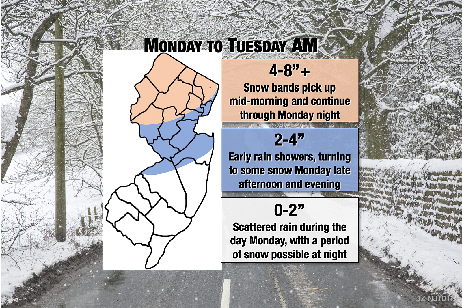
And we're not done yet, as the biggest snow accumulations are yet to come Monday, as this storm system strengthens dramatically just off the coast.
I don't want to overload you with a bunch of regurgitated forecast information. So let me boil this down to three important points:
1.) We enter a relative lull from Sunday night through early Monday morning. There will be some showers around — mainly rain away from far North Jersey. But nothing heavy. And any additional accumulations to the north will be light overnight.
2.) Monday's forecast has become even more challenging thanks to a new solution presented by the NAM model. Usually the NAM (the North American Mesoscale model) is scary-good at picking up the probability of mesoscale snow bands — those super-localized areas of super-heavy snow (1+ inch an hour) that can totally make or break a winter storm forecast. And that's exactly what it's doing late Monday, as a conveyer belt of cold air allows heavier snow to enter central and even southern New Jersey. That is countered by the lower-resolution, longer-range GFS and European models, which continue to trend nicely with my going forecast. I have tweaked my snow totals upward for northern and central NJ (drifting snowfall contours southward on the latest map). But I'm not buying a sudden flip to a half-foot of snow in South Jersey just yet. (I'll have one more opportunity to reevaluate and issue a final snow map early Monday morning.)
3.) The "main event" of this winter storm will start mid-morning Monday, as snow bands return to NW NJ. According to the going forecast (see note #2 above), non-North Jersey will remain relatively quiet during the day. Light to moderate rain will make for a yucky, but not really wintry day. However, guidance has been very persistent in showing one more push of snow Monday night. Therefore, I still think snow accumulation is possible anywhere in New Jersey by Tuesday morning. Yes, even south and coast.
A Winter Storm Warning continues for western Bergen, Morris, Passaic, Sussex, and Warren counties until Tuesday morning. Additionally, a newly upgraded Winter Storm Warning covers Hunterdon, Mercer, and Somerset counties (see note #2 above)
A less-urgent, less-severe Winter Weather Advisory remains in effect for eastern Bergen, Essex, Middlesex, and Union counties until Tuesday morning. In addition, a newly expanded Winter Weather Advisory now includes Ocean, Burlington, Camden, and Gloucester counties (again, see note #2 above).
Finally, a new Coastal Flood Advisory has been issued for coastal areas of Middlesex, Monmouth, and Ocean counties, from 10 a.m. to 4 p.m. Monday. About a foot of surge may cause minor tidal flooding of low-lying areas.
That's all for now. Next weather blog update will be published by 7 a.m. Monday. Be safe out there!

More From WPG Talk Radio 95.5 FM


