Powerful Coastal Storm Aims for NJ: Heavy Rain, Wind, Flooding
The Bottom Line
A strong coastal storm system — a nor'easter — will park off the New Jersey coast, with significant impacts expected over the next 36 hours.
The biggest concern: Very heavy rain, leading to flash flooding of roadways and low-lying areas. Secondary big concern: Strong wind gusts, potentially leading to power outages and property damage. Also: Severe weather. And let's not forget: Widespread "minor" coastal flooding along the Jersey Shore.
In other words, our stretch of nice, quiet weather is over. Monday night into Tuesday will turn wet and windy across New Jersey.

Gasp... A Nor'easter?! #Hype
I know, nor'easter is a scary term in New Jersey's weather dictionary. Usually, we think of it as a winter thing. And yes, if temperatures were 20 degrees colder, we'd be getting buried in big snow.
But the definition of a nor'easter is simply a coastal storm system that produces strong northeast ("nor'east") winds. So this definitely qualifies. And it's definitely going to get wet and windy.
Storm Timeline
As of this writing (6 a.m.) Monday morning, all's quiet across the Garden State.
And the Monday daytime hours look fine. Under mostly cloudy skies, it's going to get pretty warm. High temperatures soar into the lower to mid 70s — closer to "record" highs than "normal" highs. It will get breezy through the afternoon, with southerly gusts in the 20-30 mph range.
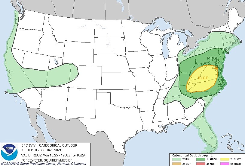
Starting around dinnertime Monday evening (6 p.m.), we'll have to watch the sky for an initial round of strong to severe thunderstorms. Gusty winds, localized downpours, and a little bit of lightning are expected. (Note: The risk for hail and tornadoes is low.)
Overnight (2 a.m.), the storm will transition to periods of steady, heavy, driving rain. That will quickly cause visibility, traction, and ponding issues as the Tuesday morning rush hour approaches.
The brunt of the storm — the time of heaviest rain and greatest flooding risk — will be centered around Tuesday morning. Rainfall rates of 1 to 2 inches will be more than enough to cause flash flooding of roadways and low-lying areas. Rivers, streams, and creeks will become swollen too.
In addition, during the Tuesday daytime hours, as the center of this powerful storm system passes just off-shore, the northeasterly wind will howl. It will get gusty across all corners of New Jersey. Top gusts will be found along the eastern edge of the state (i.e. the Shore).
I do expect some improvements and tapering by Tuesday afternoon, depending largely on the orientation of the storm system's precipitation bands. Even so, it's still going to be a wet and windy ride home during the Tuesday rush hour.
Do not expect rain to end completely until sometime Tuesday night. Showers may linger into Wednesday morning, again based on the orientation and speed of the storm system as it shoves out to sea.
Storm Impacts
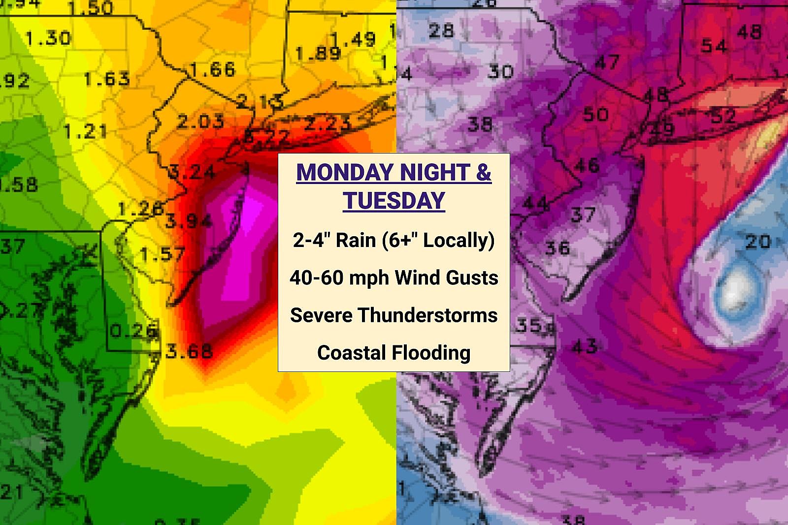
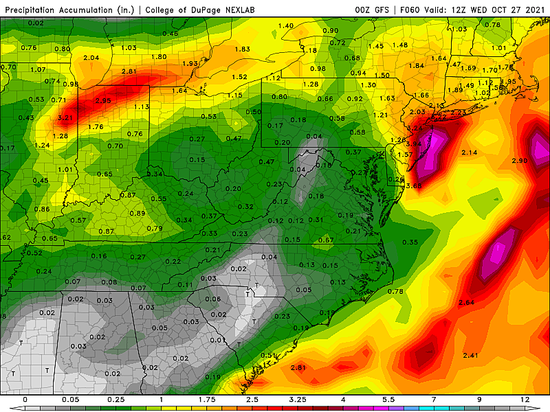
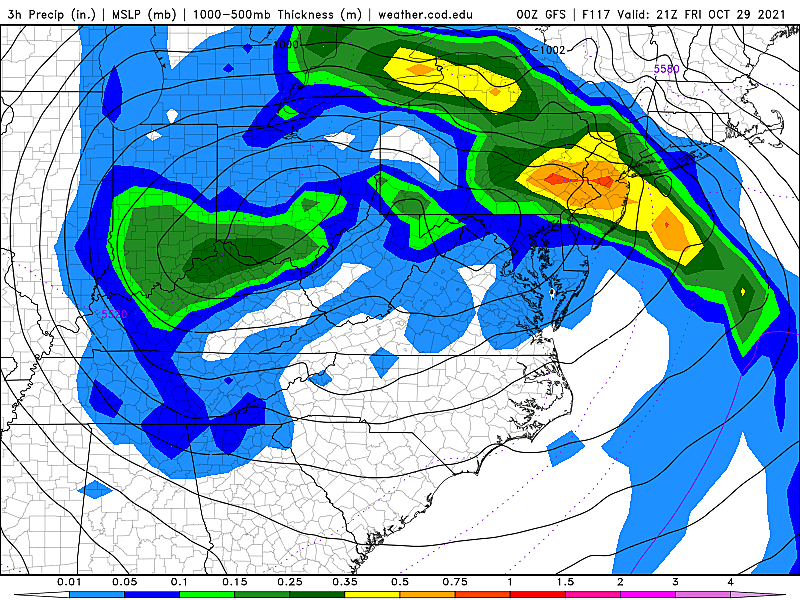
Again, my biggest concern is clearly heavy rain causing flash flooding and river flooding. Widespread 2 to 4 inches of rainfall is likely across the state. Locally higher amounts of 6+ inches seem plausible. The latest model data does show some totals as high as 8 or even 10 inches along the coast — an outlier solution, but not impossible given the long duration of the heavy downpours.
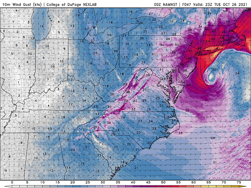
Second biggest impact will be the strong wind on Tuesday. Every part of New Jersey could see 40 mph gusts. Along the coast, closer to the center of this deep low pressure, top gusts could touch 60+ mph. That raises concerns for scattered power outages and property damage.
(College of DuPage Meteorology)
Also, remember this coastal storm will arrive with a "bang" Monday evening, with a round of strong, gusty thunderstorms at onset.
And finally, coastal flooding. That northeasterly wind will drive some water toward the Shore. Tidal models are pumping up a solid 2+ feet of surge. I tend to think that's a little overdone. Still, we'll probably see several consecutive high tide cycles with widespread "minor" category tidal flooding through both Tuesday and Wednesday. Localized "moderate" flooding is a possibility.
Advisories
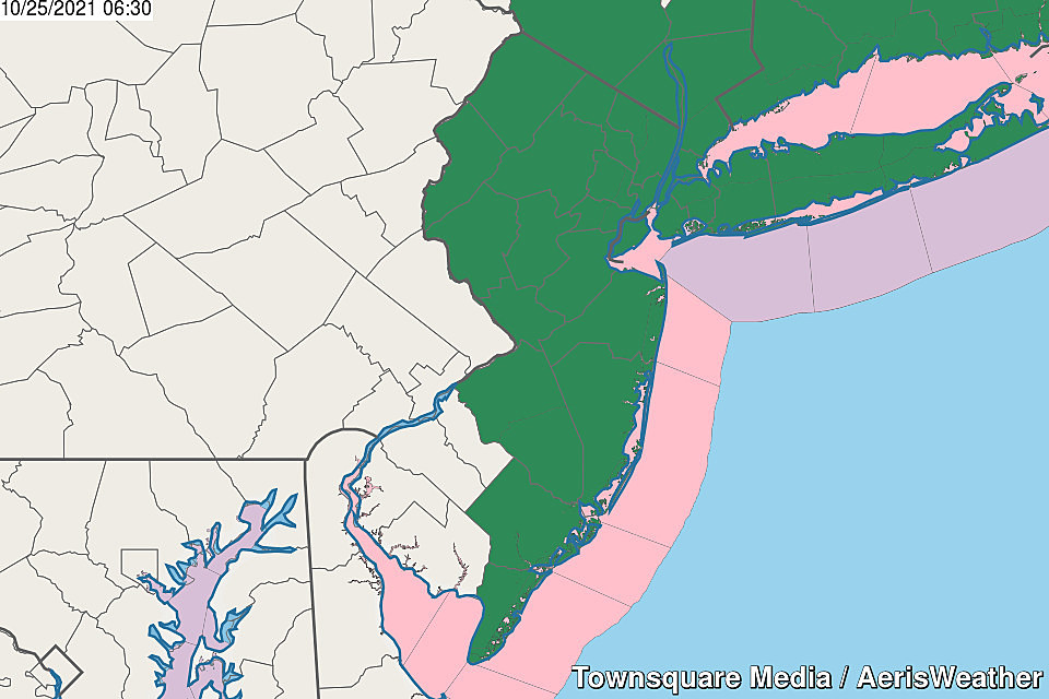
A Flash Flood Watch has been issued for 17 of NJ's 21 counties — for all but the southwestern corner of the state. That watch cautions of flooding of low-lying and poor drainage areas from Monday evening through Tuesday afternoon.
We'll probably see additional products issued for severe weather, wind, and coastal flooding as time goes on.
Another Ida?
Understandably, many New Jerseyans are on edge at the prospect of heavy rain and flooding, just eight weeks after the remnants of Hurricane Ida.
Every storm and every weather event is unique, posing its own challenges and dynamics and impacts. Having said that, I think it's only natural to draw comparisons between this coastal storm and Ida.
Will this coastal storm be another Ida? No. And I say that for several reasons:
—Even though the flash flooding threat is moderate to high, rainfall rates will not be extreme this time around. There's one big ingredient missing: rich tropical moisture. So we're talking 1-2" per hour, not 4+.
—Much drier antecedent conditions. In other words, the ground is dry and thirsty. So are our waterways. They will soak up quite a bit of rain before becoming saturated and inundated.
—The tornado threat is very low.
Still, it's important to take this significant storm seriously. There will be travel issues around New Jersey on Tuesday. But hopefully, we can avoid extreme, catastrophic flooding.
The Extended Forecast
Wednesday will be a much more pleasant day. Showers may linger through early morning, and then we'll see partly sunny skies. It will still be breezy (north up to 20 mph). High temperatures will be seasonable, in the lower to mid 60s.
Thursday looks good too, although cloudier and cooler, with highs strictly limited to the lower 60s.
And then our attention turns to yet another powerful storm system in the Thursday night-Friday-Saturday time frame. I don't want to put too much emphasis on the exact timing and impacts picture of the late week storm. (Weather is, after all, the ultimate example of "chaos theory" — one little change in the short-range forecast can have dramatic impacts on the long-range outlook.)
Given the data I reviewed this morning, Friday's storm looks like more of a windmaker than a rainmaker, with peak impacts during the day Friday. But again, be assured that we'll have much more to say about that storm starting on Wednesday.
Stay Weather Aware!
As you make your own plans to stay dry, warm, and safe during the coastal storm, so are we. Our team is mobilizing to provide the best coverage before, during, and after the storm. Both on-air and online. Thanks for following along and putting your trust in us.
BEEP BEEP BEEP: These are the 13 types of Wireless Emergency Alerts auto-pushed to your phone
Incredible, heartbreaking images of Ida's damage in New Jersey
More From WPG Talk Radio 95.5 FM