Rain Showers and Wind to Start the Thanksgiving Holiday Weekend
Ahhh, one of the busiest travel weeks of the year. So the weather forecast (and therefore my job) is extra important. There will be three weather headaches to watch in New Jersey:
1.) Scattered rain showers Wednesday
2.) Strong winds Wednesday night into Thursday
3.) Another storm system worth watching for Saturday night through Monday morning
Let's dive in...
Fantastic Weather Tuesday
Traveling early for the holiday will be a blessing this time around. Tuesday is starting with some fog, especially in central and southern New Jersey. With the temperature near the freezing mark award from the coast, there is a minimal risk of freezing fog — just be aware of potential slippery spots due to black ice through about 9 a.m.
The rest of the day looks great. Mostly sunny skies will join mild temperatures, in the upper 50s to lower 60s. (For reference, New Jersey's normal highs right now are in the lower 50s.)
Clouds will increase Tuesday evening, and a shower may even creep in after Midnight. Low temperatures should stay above freezing in the lower 40s.
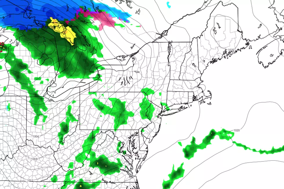
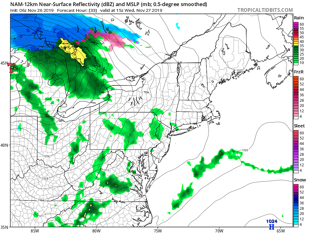
Wednesday Turns Wet
Well, a little bit wet.
A storm system will pass well north of New Jersey on Wednesday, eventually leading to a cold frontal passage at night. (More on that in a second.)
It looks like the best chance of rain will pass through the Garden State from Wednesday morning through midday. Depending on which model you prefer, the spread of that potential rainfall ranges from spotty to scattered.
In any case, it's far from a washout, it's not heavy rain, and it's not wintry. Just a few raindrops.
High temperatures on Wednesday will remain on the mild side, in the mid to upper 50s.
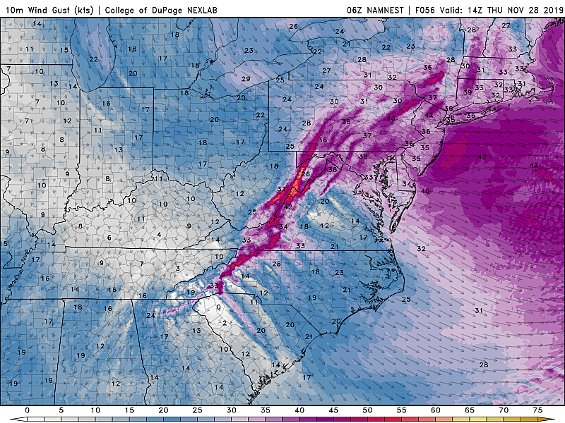
From Breezy to Windy
The wind will start to kick up Wednesday afternoon, as conditions become breezy — sustained southerly winds between 10 and 20 mph, with slightly higher gusts.
Then Wednesday night becomes downright windy, as the cold front arrives (between 9 p.m. and 1 a.m.) West-northwest sustained winds will climb to the 15 to 25 mph range. Gusts over 40 mph are possible through Thursday morning.
Those gusts may cause problems with air travel, as arrivals and departures at area airport have to be spaced out for safety. In addition, the big balloons in the Macy's Thanksgiving Day Parade in New York City are in trouble. (They don't fly if sustained winds reach 23 mph, or if gusts exceed 34 mph.)
Blustery Turkey Day
Windy, blustery conditions continue throughout Thanksgiving Day on Thursday. It will be a chilly wind too, as high temperatures come down to the upper 40s to around 50 degrees. That's actually pretty close to normal for this time of year.
The rest of your Thanksgiving forecast is fine, as we see a mixture of sunshine and clouds. Weather will remain dry.
Quiet Black Friday
Do people even wait in line on Black Friday morning anymore? Well, if you do, you'll have to bundle up a bit. Morning low temperatures just below freezing. Afternoon highs in the upper 40s. Sunny skies and lighter winds.
Another Storm System
The end of the holiday weekend could feature even more impactful weather for travelers to/from New Jersey. This one is starting to look nor'easter-ish. And with 4 to 5 days until the start time, we can only talk about the timeline and potential impacts — not specific details just yet.
Things could start as early as Saturday late afternoon. As temperatures cool into Saturday night, a period of wintry mix of snow, sleet, and/or freezing rain is possible. (Which one falls will depend on the exact temperature, both at the surface and up in the air.)
During the day Sunday (the first of December, by the way), I'm seeing more of a scattered rain forecast as easterly winds warm thermometers to the upper 40s.
But if this storm system intensifies off the coast Sunday night to Monday morning, a big cooldown could force a flip to straight snow, sleet, and/or freezing rain.
Snow accumulations? Possible. Ice accumulations? Possible. Travel impacts? Probable, even if it's all rain. Definitely worth watching — although it's important to realize that a lot can change by the weekend.
I realize how important this particular forecast is. We'll be able to piece together more specific storm details starting on Thursday. Even though it's a holiday weekend, the weather doesn't take time off and neither does the Townsquare New Jersey Weather Network!

More From WPG Talk Radio 95.5 FM


