
Steamy, Stormy Saturday for NJ: T’storms and Downpours Usher in Cooldown
The Bottom Line
Welcome to the weekend! This mid-July weekend is, on average, New Jersey's hottest of the calendar year. We sure have endured some intense, long-lasting heat and humidity over the past couple of weeks.
Our next big transition will happen this weekend, as a slow-moving cold front passes overhead. First it will be steamy, with the continuation of high humidity and hot temperatures. Then, things will turn stormy, with the resurgence of serious flash flooding concerns.
Despite the deservedly dramatic headlines, there is some good news in the forecast too. By early next week, both temperatures and dew points will dial back to more reasonable, more seasonable, more comfortable levels.
Since there's a ton of summertime outdoor activities going on this weekend - and because those plans may be in jeopardy - I wanted to lay out a detailed timeline of how the weather will be changing and what you should look out for.

Saturday Morning to Midday: Steamy
Saturday will be the 6th and final consecutive day of 90s in New Jersey.
I'm not sure if you've been outside yet, but the humidity is just disgusting. Dew points are firmly in the 70s statewide, making the air soupy and stifling.
High temperatures across most of NJ Saturday are expected to range from 87 to 93 degrees. The heat index (the "feels like" or "apparent" temperature) may exceed 100 during the hottest part of the day.
A Heat Advisory covers most of the state until 8 p.m. Saturday, calling for potentially dangerous conditions, conducive to heat exhaustion and heat stroke. You know the drill by now: Dress appropriately, take cool breaks, and stay super duper hydrated.

Yes, you will find some relief at the Jersey Shore, as long as the sea breeze machine fires up. But it's still going to be a sticky, steamy, summery day. Also keep in mind, a Moderate Risk of rip currents is posted for the Shore on this assuredly busy beach day.
Saturday Afternoon: Scattered Strong Storms
In the juicy air, pre-frontal thunderstorms are expected to pop up over New Jersey starting around 2 p.m. Saturday (give or take). These storm cells will develop and grow very quickly. They will be capable of producing localized downpours, frequent lightning, and gusty winds. Some hail and an isolated tornado are possible too.
Initial afternoon storms will be hit or miss. At least part (if not most) of New Jersey will stay storm-free and rain-free.
If a storm pops up in your vicinity, it will put a quick end to any outdoor activities. Keep an eye and an ear on the sky. (And weather radar too.) And be prepared to seek shelter if the sky starts to darken. When thunder roars, head indoors.
Saturday Night: Heavy Rain, Flooding Concerns
The "main event," with the most widespread rain, will hold off until Saturday evening. I don't see these pockets of steady, heavy rain to really ramp up until after 7 p.m. Saturday. And the worst of it should clear the coast just after Midnight Lingering showers are possible through 5 a.m. Sunday.
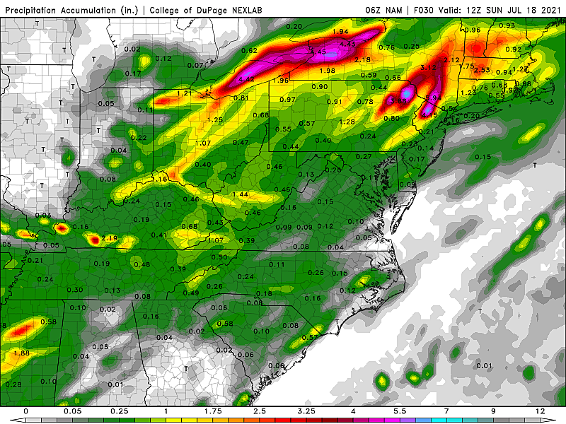
I think everyone in New Jersey gets wet here, if not soaked. Average rainfall will be about an inch.
However, some models are pumping out 3 to 6 inches of rain for part of North Jersey by Sunday morning. That is incredibly concerning, due to the threat of flash flooding.
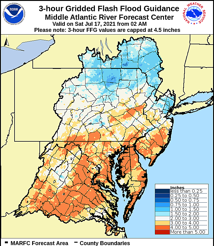
We use a product called "Flash Flood Guidance" to approximate the minimum amount of rainfall that would cause a flooding situation. For New Jersey on Saturday, that number ranges from about an inch and a half in water-logged NE NJ to upwards of 4 inches in South Jersey. Needless to say, the forecast falls right in that zone.
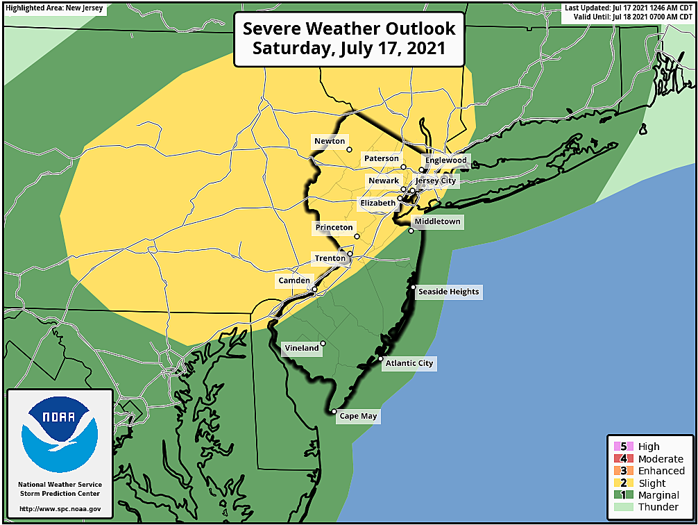
A Flash Flood Watch has been issued for almost the entire state, only excluding inland Atlantic, Cape May, and Cumberland counties. The watch runs from 2 p.m. Saturday through 2 a.m. Sunday. (Covering the afternoon scattered thunderstorms, in addition to the evening big push.)

While not every New Jerseyan will see a flooding deluge Saturday, this is a pretty serious situation. Please stay alert to changing weather conditions, and heed any warnings that are issued. Never attempt to drive, walk, or swim through flooding areas - it's not only dangerous, but floodwater is also pretty disgusting.
Sunday: Only Spotty Showers, Not as Hot
The forecast for the second half of the week has trended progressively better, as the aforementioned crawling cold front makes a clean passage through the state.
Overnight rain should taper by sunrise Sunday. However, on the backside of the parent low pressure system to the northeast, there could be some spotty shower activity. The best chance for raindrops Sunday will be 1.) in the morning, and 2.) in North Jersey.
Cloud cover may be a bit thicker than you'd like too, especially through the first part of Sunday.
Meanwhile, as dew points slip backward from the 70s to the 60s, the air will finally start to feel less tropical. Still sticky and still warm - but not as stifling and thick.
High temperatures on Sunday will be limited to the mid 80s, at the warmest. Close to (or just below) mid-July normals.
Next Week: Better
There will be a daily chance of an isolated shower or thunderstorm for Monday, Tuesday, and Wednesday. There could be some scattered 90s around, especially Tuesday and late-week.
But as long as dew points stay in the 60s and we get some overnight low temperatures in the 60s, the weather will be quite manageable. Especially after another cold frontal passage around Wednesday, I'm happy to say our weather generally looks bright and seasonable.
Next threat of heavy rain will probably come at the end of next week.
8 sharks you may find off New Jersey's coast
Gallery Credit: Dino Flammia
Inside Amazon: A Detailed History of America's Biggest Online Retailer
Gallery Credit: Andrew Lisa
More From WPG Talk Radio 95.5 FM


