Thursday NJ Weather: More Rain Ahead, Big Cooldown This Weekend
The Bottom Line
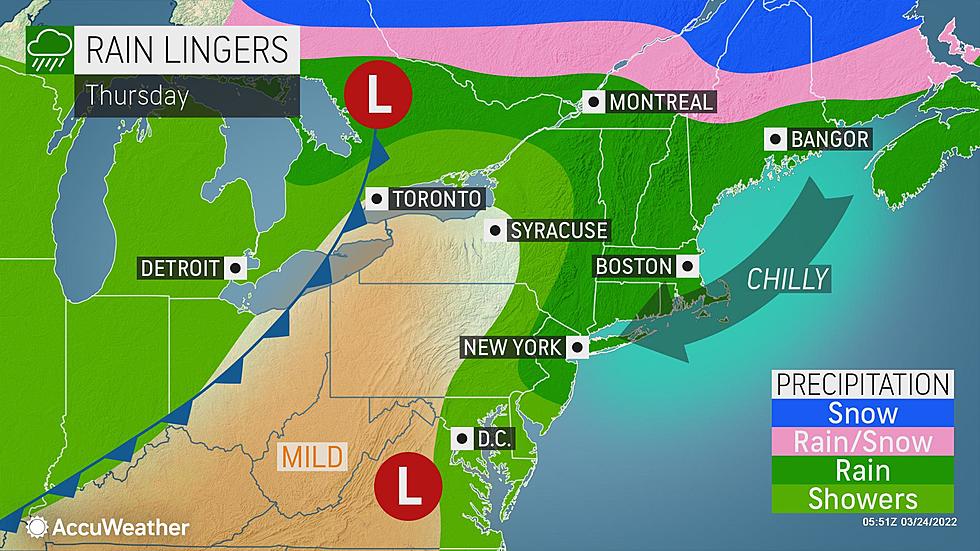
As a broad area of low pressure travels from the Great Lakes to eastern Canada Thursday, we have more clouds and more wet weather in New Jersey's forecast. In other words, a dreary, unsettled day.
Parts of the state saw over an inch and a half of rain overnight, with wind gusts as high as 32 mph. The heaviest, steadiest, most widespread stuff is behind us now. But don't expect our weather to dry out completely for another 24 hours.
We aren't facing an arctic blast immediately behind this storm system. In fact, Friday looks quite pleasant. However, a shot of cold air this weekend will send temperatures tumbling again.
By next week, we'll be talking about morning hard freezes and afternoon temperatures well below seasonal normals. Hope you've kept your winter coat handy.
Thursday
As of this writing (6:30 a.m.), the heaviest rain has exited the coast. We're left with puddles, wet conditions, fog, and occasional showers.

And that's pretty much the story of Thursday's daytime hours. On and off showers, with some pockets of heavier stuff along the way. Cloudy skies, calm wind, dreary conditions. By the afternoon, the best chance of rain will shift to southern and coastal New Jersey. So most of New Jersey should see significant breaks and lulls in the rainfall action. But carry the umbrella, just in case.
Meanwhile, we have a thermal boundary set up directly over New Jersey too. So temperatures are very different between the top and the bottom of the state. North Jersey will progress from the 30s Thursday morning to no better than mid 40s Thursday afternoon. South Jersey is starting off near 60. A brief rise into the lower 60s will be followed by a dip into the 50s later on.
One more push of solid rain is expected statewide Thursday evening, kicking in between about 8 p.m. and 11 p.m. Additional rainfall may exceed a half-inch.
Friday
Just before dawn Friday morning, rainfall will be limited to just exiting coastal showers. By late Friday morning, we should see substantial breaks of sun.
Therefore, I have no hesitation in saying Friday will turn into a nice day. It will be breezy, but mild, with high temperatures around 60 degrees.
Soak it in, because Friday will be the warmest day of the next six or seven. At least.
Saturday
Saturday will be a day of transition. A cold front will slide across New Jersey in the middle of the day, producing showers and starting a big cooldown.
Aside from the spotty midday rain, we'll see a mix of clouds and sun. High temperatures will be seasonable in the lower to mid 50s or so.
Sunday
Morning lows in the 30s. Afternoon highs only in the 40s. Yeah, that's pretty cold for the first weekend of spring. Especially with the stiff northwesterly breeze of 20+ mph.
I settled on partly sunny skies and a dry forecast for Sunday. (However, the chance of a sprinkle or flurry isn't zero.)
Monday & Beyond
Monday will be the bottom of the barrel of our impending cold snap. Almost the entire state (away from the immediate coast) will hard freeze Monday morning, with lows in the 20s. (Maybe even some teens to the northwest.) And thermometers will struggle to reach 40 degrees. That is about 15 degrees below normal for the last week of March.
40s on Tuesday and closer to 50 on Wednesday. Better, but still unseasonably cool.
At the moment, I do not see any pressing threat of wintry weather in our immediate future. But that's obviously something we'll have to watch closely, with cold air in the neighborhood.
St Peters enters NCAA Sweet 16, NJ gets Peacock Fever
Gallery Credit: Associated Press
Where everyone knows your name: Friendliest bars in NJ
Gallery Credit: Jordan Jansson
More From WPG Talk Radio 95.5 FM


