
Wintry Mix Will Make NJ Roads Icy, Slushy, and/or Wet Tuesday
So far, our “winter storm” has been rather unimpressive. There were some snowflakes and raindrops around South Jersey overnight. But our air is very dry, which is making for a quiet start to Tuesday.
However, as our atmosphere will moisten up as the next band of this system arrives late Tuesday morning. Weather and road conditions may slide downhill through the early afternoon hours.
As we’ve been discussing ad nauseum, this is absolutely not a “major” winter storm. But you will have to stay alert to the changing weather.
(Traditionally, I do not issue updated snowfall maps when a winter storm is already in progress. However, since this one has barely started, I think the picture makes the forecast much clearer. A worthy exception to the rule.)
Our Winter Weather Advisory has been shaved away, since there is little threat for hazardous winter weather in southern New Jersey at this point. That advisory is now in effect for the following counties and times:
—Until 1 p.m. Tuesday… Mercer
—Until 4 a.m. Wednesday… Hunterdon and Somerset
—7 a.m. Tuesday to Midnight Wednesday… Essex, Hudson, and Union
—7 a.m. Tuesday to 4 a.m. Wednesday… Morris, Sussex, and Warren
—7 a.m. Tuesday to 6 a.m. Wednesday… Bergen and Passaic
Let’s further break down the forecast by region. And we have to look at the longer-range forecast too, with two more winter storms on the horizon.
North Jersey (Blue)
The coldest corner of New Jersey will probably see light snow accumulations. It will be a slow build to 1-3", with light to (occasionally) moderate snow from about 10 a.m. Tuesday right through Tuesday night. Mixing (with sleet and/or rain) through the mid-late afternoon hours is a possibility, which would further reduce those meager snowfall totals.
I expect snow to wrap up completely by daybreak Wednesday morning, at the latest.
South Jersey (Green)
The southern half of the state (approximately south of Interstate 195) will be above-freezing as precipitation fills in late Tuesday morning (between about 9 a.m. and Noon). So we’re facing almost exclusively wet weather here.
Having said that, the ground is cold, so initially there could be some icy spots due to freezing drizzle or rain. Additionally, don’t be surprised if you see snowflakes or sleet pellets mixed in with the rain. Rainfall totals will end up close to a quarter-inch.
Spotty rain will wrap up Tuesday early evening. As conditions dry out overnight, temperatures should stay above-freezing. So a flash freeze is not expected. Locally dense fog will be possible Tuesday night through Wednesday morning.
The Middle (Pink)
Precipitation type here will be variable from onset (around 10 a.m.) through about mid-afternoon. That makes impacts and accumulations very difficult to forecast.
The ground is cold. (5cm soil temperatures are hovering around the freezing mark.). So it won’t take much snow, sleet, and/or freezing rain to slicken up untreated surfaces. Snow/sleet accumulation will be light in this zone — no more than an inch.
By late afternoon, we’ll probably flip from light wintry mix to light rain. Things will taper off and wrap up in the early evening hours. (Although additional showers may impact parts of North Jersey through Tuesday night too.)
Locally dense fog will be possible overnight. With a hard freeze unlikely, a flash freeze is not a concern.
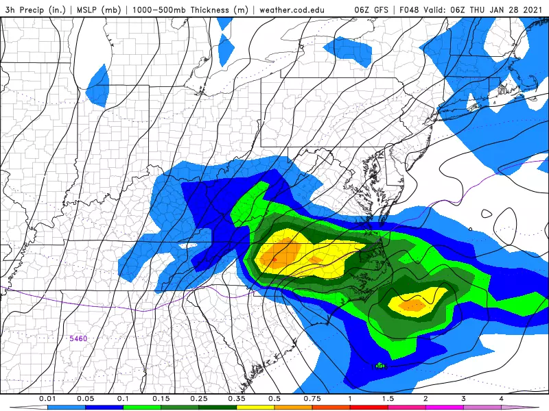
The Next Storm: Thursday
Models have come to a consistent consensus, and this (more powerful) storm system looks to pass just to our south. It’ll be mainly a miss for New Jersey.
It’s a close call, but I’m becoming increasingly confident we won’t face any significant weather from this one. I do have to include some snow/rain showers in the forecast for far southern and coastal New Jersey early Thursday morning. And we’ll see some cloud cover across the state too.
More importantly, that storm system will once again open the door to some very cold air. Thursday will turn windy and cold, in the mid 30s. Friday’s highs may only reach the mid 20s.
The Next Next Storm: Sunday-Monday
Now this one looks interesting. Both the GFS and Euro show a strong area of low pressure tracking directly over New Jersey. To varying degrees, this could lead to a much more significant and impactful blast of winter.
Some models are painting double-digit snowfall totals over New Jersey — although that doesn’t mean very much 5-6 days in advance.
The big question: Will it be cold enough for an all-snow event for New Jersey? That will be highly track-dependent.
So we’ll patiently remain in a holding pattern, keeping this storm in the “worth watching” category for now. I suspect we’ll be able to dig into more confident details on this late weekend storm around Thursday. Stay tuned!

READ MORE: See 50 remote jobs that can pay well
More From WPG Talk Radio 95.5 FM


