Latest update on NJ’s next big storm and weekend arctic blast
The Bottom Line
This is another one of those forecasts where you just want to scream at the sky "Enough already!" New Jersey's hyper-active weather pattern continues. With not one, not two, but three big weather headlines to talk about:
1.) Another nasty rain/wind storm. While Friday night's storm system is "a notch below" the severity and intensity of Tuesday night's rain/wind machine, it still poses a threat for flooding and power outages.
2.) Big, blustery cooldown. Beyond the storm, temperatures take a big tumble throughout the weekend, with a persistent brisk wind. Next week looks quite frigid.
3.) Chance of snow. With fresh cold air in place, we have to watch a potential storm system around Tuesday-Wednesday of next week. Still not a slam dunk — it could swing completely out to sea. Statewide accumulating snow is a possible scenario..

Headline #1: Another Nasty Rain/Wind Storm
Tuesday night's storm, by the numbers. Top rainfall total 4.40" (Oak Ridge Reservoir, Passaic County). Top wind gust 72 mph (Island Beach State Park). Top snowfall total 1.5" (Wantage, Sussex County).
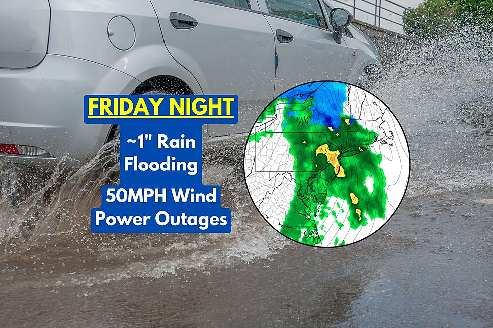
Friday night's storm forecast, by the numbers. Top rainfall totals just over an inch. Top wind gusts about 40 to 50 mph. Top snowfall total less than a half-inch, in NW NJ only.
In terms of severity and intensity, Friday night's storm is clearly not the strongest of the week. But we still need to take it seriously, especially since the ground is still soaked and rivers are still raging.
The daytime hours on Friday will be fine. Clouds will increase, as temperatures rise into the mid 40s by the afternoon. Thermometers will continue rising, well into the 50s late Friday night.
First raindrops will push across the Delaware River in SW NJ by about 7 p.m. Friday. The brunt of the storm — the period of heaviest rain and strongest winds — will be from about 10 p.m. to 4 a.m. Final raindrops should be clearing the state around 7 a.m. Saturday. It is 12 hours of stormy, inclement, potentially nasty weather. And clearly an "overnight" storm.
The biggest concern here is for a resurgence of flooding. The saturated ground will make flash flooding occur quickly, even with only an inch of rain. And rivers, streams, and creeks are still running high — especially in North Jersey, where the Passaic River has crested over Major flood stage. Not a good starting point for even more rain and runoff.
The wind will also be significant, as 50 mph gusts potentially cause downed trees and branches. (Again, trees are weakened by the soggy soil.) Scattered power outages are possible yet again.
And the ocean will get churned up in the wind, causing one or two rounds of coastal flooding. Tidal guidance is reading mainly minor category flooding, although Ocean County in particular could surpass moderate flood stage on tidal waterways. The high tide cycle of concern is Saturday morning.
We have a variety of advisories covering this high-impact, multi-hazard storm:
—Flood Warnings continue for several waterways, mainly in North Jersey, still at or above flood stage.
—A Flood Watch calls for potential water inundation of flood-prone areas, between Friday evening and Saturday morning. It is not for the entire state this time, but for most counties: Bergen, northwestern Burlington, Camden, Essex, Gloucester, Hudson, Hunterdon, Mercer, Middlesex, western Monmouth, Morris, Passaic, Somerset, Sussex, Union, and Warren.
—A Wind Advisory has been issued for southern and coastal counties from 8 p.m. Friday to 5 a.m. Saturday, as wind gusts may reach 50+ mph. Counties under this advisory include Atlantic, Burlington, Camden, Cape May, Cumberland, eastern Essex, Gloucester, Hudson, Monmouth, Salem, and eastern Union.
—A Coastal Flood Warning covers the Delaware River — northwestern Burlington, Camden, Gloucester, and Mercer counties — from Midnight to 7 p.m. Saturday. A renewed push into moderate category flooding is forecast.
—Another Coastal Flood Warning for Ocean County is in effect from 6 p.m. Friday to 7 p.m. Saturday, calling for one or two rounds of minor to moderate flooding of tidal waterways.
—A Coastal Flood Advisory serves as a less-severe, less-urgent heads-up that minor tidal flooding may occur along other Shore points. Atlantic, southeastern Burlington, Cape May, Middlesex, and Monmouth counties fall under an advisory from 6 a.m. to 2 p.m. Saturday. Eastern Bergen, Cumberland, eastern Essex, Hudson, eastern Union have the advisory posted from 7 p.m. Friday to 2 p.m. Saturday. And Salem County, at the intersection of the Delaware Bay and Delaware River, is under an advisory from 8 p.m. Friday to 2 p.m. Saturday.
Bottom line: Our weather turns nasty again Friday night. Just stay home, if you can.
Headline #2: Big, Blustery Cooldown
After the rain wraps up Saturday morning, skies should clear quickly to partial sunshine. And then our attention turns to wind and cold through the rest of the weekend.
On Saturday, a brisk westerly wind will push temperatures sharply downward throughout the day. While we'll be close to 60 degrees at sunrise, thermometers will be closer to 40 degrees by sunset. Top wind gusts will likely be in the 30 to 40 mph range.
Saturday night will not be that cold, as low temps settle around 30 degrees. But the wind will continue to blow, potentially sending the wind chill ("feels like" or "apparent" temperature) deep into the 20s.
Sunday will feel like a midwinter day. Despite sunshine, high temperatures will only reach the upper 30s on average across the state. (That is actually close to normal for this time of year.)
A secondary cold front could spark a few flurries Sunday afternoon. And then temperatures will tank even more.
By Monday morning, we could see widespread teens. Monday's highs will struggle to reach the freezing mark, in the lower 30s.
Bottom line: Get ready to bundle up.
Headline #3: Chance of Snow
With two big weather events in the way, the forecast for next week gets especially hazy. But there is a signal for a potential coastal storm system in the Tuesday-Wednesday time frame.
It is too early to get into the nitty-gritty about timing and accumulations, But I believe there are three strom track scenarios as it stands right now:
1.) An out-to-sea track or glancing blow. We could see some snowflakes, or even nothing at all. Maybe even an inch to the southeast. Especially given the cold, dry air mass that will firmly grip the Northeast, I give this "almost nothing" solution a slight preference at this time.
2.) Inland track. If the low pressure hugs the coast too closely, we will end up on the warm side. And the result would be a messy mix of rain and snow. Some accumulation would be possible, especially for far inland areas. This is the least likely solution of the bunch.
3.) South Jersey special. There is a good chance for an "all snow" solution, given our impending arctic air. And there is a "perfect" storm track that would bring light to moderate snow accumulations to inland New Jersey, and moderate to heavy accumulations to the southeast coast. Somewhere in the neighborhood of 3 to 9 inches — definitely enough to grab the shovel.
Bottom line: It is January, and it will snow eventually. We will handle this Tuesday-Wednesday snow chance with more urgency if the need arises. Probably starting this weekend.
Glossary of NJ winter weather words and phrases
Gallery Credit: Dan Zarrow
Dan Zarrow is Chief Meteorologist for Townsquare Media New Jersey. Follow him on Facebook for the latest forecast and realtime weather updates.
First flakes: When does snow season start in NJ?
Gallery Credit: Dan Zarrow
More From WPG Talk Radio 95.5 FM


![New Atlantic City Casino Beach Club Set To Open — Food, Bar [Photos]](https://townsquare.media/site/564/files/2026/06/attachment-img_2853-18.jpeg?w=980&q=75)